
Lake Pedder facts for kids
Quick facts for kids Lake Pedder |
|
|---|---|

Lake Pedder, c. 1970
|
|

Lake Pedder
Location in Tasmania
|
|
| Location | South West Tasmania |
| Coordinates | 42°56′S 146°08′E / 42.933°S 146.133°E |
| Type | |
| Etymology | Sir John Pedder |
| Part of | Upper Gordon River hydroelectric generation scheme |
| Primary inflows | Frankland Range |
| River sources |
|
| Primary outflows |
|
| Catchment area | 734 km2 (283 sq mi) |
| Basin countries | Australia |
| Construction engineer | Hydro Tasmania |
| First flooded | 1972 |
| Surface area | 242 km2 (93 sq mi) |
| Average depth | 13–16 m (43–52 ft) (as a reservoir) |
| Max. depth |
|
| Water volume | 2.9 km3 (0.70 cu mi) |
| Surface elevation | 300 m (980 ft) |
| Islands |
|
Lake Pedder is a large lake in the southwest of Tasmania, Australia. It was once a natural lake formed by glaciers. But since 1972, it has been a man-made reservoir. This means it's a large artificial lake used to store water.
The lake was created by building dams across the Serpentine and Huon rivers. This was done by a company called Hydro Tasmania. Their goal was to make hydroelectricity, which is power made from moving water.
Today, the new Lake Pedder covers about 242 square kilometres (93 sq mi). This makes it the second largest lake in Tasmania.
Contents
Original and New Lake Pedder
In the early 1900s, the first Lake Pedder was named after Sir John Pedder. He was the first Chief Justice of Tasmania. The name was later given to the new, much larger lake.
Even though the new lake includes the old one, they are very different. The new Lake Pedder is much bigger. It also looks and feels different, and the plants and animals around it have changed.
The new lake is held in place by three main dams:
- Serpentine Dam – This dam is 38-metre (125 ft) tall. It is a rockfill dam built on the Serpentine River.
- Scotts Peak Dam – This dam is 43-metre (141 ft) tall. It is also a rockfill dam, located on the upper Huon River.
- Edgar Dam – This dam is 17-metre (56 ft) tall. It is a rockfill dam near Lake Edgar.
These dams were built by Hydro Tasmania. They were part of a big plan to create more hydroelectric power. The Tasmanian Government wanted to attract new industries. They offered cheap renewable energy to make this happen.
The new lake filled up after the dams were finished in 1972. Its water flows into Lake Gordon through a canal. Together, Lake Pedder and Lake Gordon form Australia's largest water storage system.
Why Lake Pedder Was Dammed
Building the dams and flooding Lake Pedder caused many protests. People in Tasmania and mainland Australia were very upset. Protests started in 1967. This was when the Tasmanian Government removed the protected status of the Lake Pedder National Park. The park had been protecting the lake since 1955.
Many people felt that Hydro Tasmania had too much power. They believed the company was acting like a part of the government. They thought it was ignoring public opinion about the environment.
Tasmania's leader at the time was Premier Eric Reece. He and Allan Knight, the head of Hydro Tasmania, strongly supported the dam project. They even ran advertising campaigns to convince people it was the right choice.
Premier Reece was known for supporting Hydro Tasmania's power plans. He was even nicknamed "Electric Eric." In 1972, he approved the flooding of Lake Pedder. This happened despite strong protests. The Australian Prime Minister, Gough Whitlam, even offered money to save the lake. But Reece refused, saying the federal government should not interfere with Tasmania's decisions.
"There was a National Park out there, but I can't remember exactly where it was . . . at least, it wasn't of substantial significance in the scheme of things. The thing that was significant was that we had to double the output of power in this state in ten years in order [to] supply the demands of industry and the community. And this was the scheme that looked as though it could do a greater part of [the] job for us."
Photographs from the 1976 Tasmanian Year book showed how the Lake Pedder area was flooded.
Animals Affected by Lake Pedder Flooding
The flooding of Lake Pedder had a big impact on some animals.
The Lake Pedder earthworm (Hypolimnus pedderensis) was found only on a beach at Lake Pedder in 1971. After the lake was flooded, this worm was never seen again. A search in 1996 could not find any. Since 2003, it has been listed as extinct. This means it no longer exists anywhere.
Another animal affected was the Lake Pedder planarian (Romankenkius pedderensis). This is a type of flatworm. It was also listed as extinct since 1996. However, in 2012, some reports suggested that this species might still exist.
The Pedder galaxias is a type of Australian freshwater fish. It is considered extinct in its natural home of Lake Pedder. But it still lives in captivity. It also lives in two other places where it was moved for safety. One place is Lake Oberon in the Western Arthurs mountains. The other is a modified water dam near Strathgordon.
Campaign to Restore Lake Pedder
There is a group called the Lake Pedder Restoration Committee. They want to bring the lake back to its original state. This effort is part of the United Nations Decade of Ecological Restoration, which runs from 2021 to 2030.
The committee hopes to get government agreement to restore the lake before 2031. Key people involved include Christine Milne, Todd Dudley, Bob Brown, and Paul Thomas.
Images for kids
-
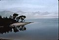
Shores of Lake Pedder, c. 1970.
-
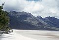
Photograph of Lake Pedder Beach, March 1966.


See also
 In Spanish: Lago Pedder para niños
