Arthur Range (Tasmania) facts for kids
Quick facts for kids Arthur Range |
|
|---|---|

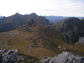
Looking across High Moor from Mount Columba towards Mount Capricorn and Mount Pegasus
|
|
| Highest point | |
| Elevation | 1,224 m (4,016 ft) AHD |
| Parent peak | Federation Peak |
| Geography | |
| Country | Australia |
| State | Tasmania |
| Region | South West |
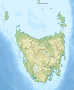
| Range coordinates | 43°12′S 146°25′E / 43.200°S 146.417°E |
The Arthur Range is a group of mountains in Tasmania, Australia. It is found in the wild South West Wilderness area. This range has two main parts: the Western Arthurs and the Eastern Arthurs.
Both parts of the range are popular for bushwalking trips. People often visit them for overnight hikes, especially during summer.
Contents
History of the Arthur Range
The Arthur Range is part of the traditional lands of the Aboriginal Tasmanian people. Their traditional name for this area is Loinnekumme.
The range was later given its current name by George Augustus Robinson. He named it after George Arthur, who was the Governor at the time. Robinson climbed a mountain called Mount Frederick (now Mount Hayes) in March 1830.
What the Mountains are Made Of (Geology)
The Arthur Range is mostly made of a hard rock called Quartzite. This rock is very strong and resistant to weather.
You can also see signs of a past Ice Age here. These signs include moraines, which are piles of rock and dirt left behind by glaciers. There are also hanging valleys, which are valleys that stop high up on a mountain side.
Plants and Animals (Flora/Fauna)

Much of the Arthur Range is covered by "button grass" wet sedgelands. This is a type of grassy wetland. Other parts of the land have eucalypt trees.
Birds are the most common animals you will see here. For example, you might spot Yellow-tailed Black Cockatoos. In drier areas, you might also see Pademelons, which are small marsupials.
Weather in the Arthur Range (Climate)
The weather in the Arthur Range can change very quickly. Weather forecasts are often not very helpful here. It is common to experience sunshine, heavy rain, clouds, strong winds, and even snow all in one day!
The tops of these mountains are considered Sub-Alpine or Alpine. This means they are very cold. During winter, the mountains are covered in snow. Snow can even fall in summer, though it often melts quickly. The wind plays a big role in the temperature. Warm air can come from northern Tasmania, or very cold air can blow in from the Southern Ocean and Antarctica.
Hiking in the Arthur Range (Walking)
The trails in Tasmania's south-west, including the Arthur Range, can be very muddy. Often, the mud is deeper than your ankles! The mud stays even as you go higher up the mountains, unless you are on bare rock.
This area is also at risk from a plant disease called Phytophthora. This disease causes plants to rot. To help stop it from spreading, hikers should stay on the main trails. Also, to protect plants, walkers are asked to walk through the middle of muddy sections.
Hikers should always be ready for any kind of weather. It is also wise to carry enough food for an extra day or two, just in case.
Western Arthurs
The Western Arthurs stretch from Mount Hesperus to West Portal. This part of the range was first explored by hikers in the early 1960s.
You can usually get to the Western Arthurs from the Scotts Peak Dam campsite. This involves walking along part of the Port Davey Track.
Lakes of the Western Arthurs
The Western Arthurs have many lakes. These lakes were formed by glaciers during the Ice Age. Some of these lakes include:
- Lake Oberon (43°08′55″S 146°16′20″E / 43.14861°S 146.27222°E): This lake is famous because of a well-known photograph by Peter Dombrovskis. There are also special camping platforms here.
- Lake Cygnus (43°07′49″S 146°14′16″E / 43.13028°S 146.23778°E): This lake also has a proper campsite.
- Lake Ceres (43°08′29″S 146°15′11″E / 43.14139°S 146.25306°E)
- Square Lake (43°08′29″S 146°15′46″E / 43.14139°S 146.26278°E)
- Lake Fortuna (43°07′31″S 146°13′39″E / 43.12528°S 146.22750°E)
Mountains of the Western Arthurs
Here are some of the mountains in the Western Arthurs, starting from the north-western end:
- Mount Hesperus (1099m)
- Mount Hayes (1119m)
- Procyon Peak (1136m)
- Mount Sirius (1151m)
- Mount Pegasus (1063m)
- Pegasus South (1053m)
- Mount Capricorn (1037m)
- Dorado Peak (1068m)
- Mount Comumba (1042m)
- The Dragon (1006m)
- Mount Shaula (914m)
- Mount Taurus (1011m)
Eastern Arthurs
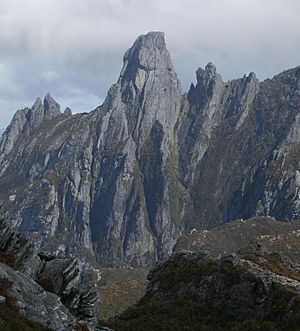
The Eastern Arthurs run from north to south. They start where the Western Arthurs end. This section includes the highest peak of the entire range, the impressive Federation Peak. A group from the Hobart Walking Club first hiked through this area in December 1947.
Lakes of the Eastern Arthurs
Here are some of the lakes in the Eastern Arthurs, starting from the north:
- Lake Leo
- Lake Ron Smith
- Lake Shaw
- Earl Lake
- Lake Cracroft
- Lake Brewsher
- Dragonfly Lake
- Lake Payens
- Lake Gaston
- Hanging Lake
Mountains of the Eastern Arthurs
Here are some of the mountains in the Eastern Arthurs, starting from the north:
- Cerberus Hill (541m)
- East Portal (1008m)
- The Dial (1083m)
- The Gables (1058m)
- Four Peaks (1062m)
- Federation Peak (1225m)
- Geeves Bluff (1152m)
Other Named Features
- Luckmans lead
- Boiler Plates
- Stuart Saddle
- The Needles
- Goon Moor
- Thwaites Plateau
- Devils Thumb
- Bechervaise plateau
 | Precious Adams |
 | Lauren Anderson |
 | Janet Collins |


