
Southwest National Park facts for kids
Quick facts for kids Southwest National Park |
|
|---|---|
|
IUCN Category II (National Park)
|
|
 |
|
| Nearest town/city | Strathgordon |
| Coordinates | 42°50′01″S 146°08′58″E / 42.83361°S 146.14944°E |
| Area | 618,267 ha (1,527,770 acres) |
| Established | 1955 (as Lake Pedder NP) |
| Managing authorities | Tasmania Parks and Wildlife Service |
| Official site | Southwest National Park |
The Southwest National Park is a huge national park in the southwest part of Tasmania, Australia. It covers about 618,267-hectare (1,527,770-acre) of land. This park is the biggest in Tasmania and is part of the amazing Tasmanian Wilderness World Heritage Area. This means it's a very special place recognized around the world!
The park is about 93 kilometres (58 mi) west of Hobart, which is Tasmania's capital city. It stretches all the way to the west and south coasts. Most of Tasmania's wild, untouched areas in the southwest are found here. People love this park because it's so remote and natural. The weather can change very quickly and become severe, so visitors need to be prepared.
Humans haven't changed much in this area. Evidence shows that Aboriginal people have visited this land for at least 25,000 years. European settlers have explored the park, but they haven't built many long-lasting towns or changed the environment much. There's only one road leading into the park, which goes to the town of Strathgordon. This town uses water power to make electricity. The southern and western parts of the park are very remote. You can only get there by walking, by boat, or by small plane.
The tiny town of Melaleuca is in the far southwest of the park. It has a small runway where planes can land. There are also basic buildings for the National Parks Service there.
Contents
Park History
Most of the Southwest National Park was first created in 1955. Back then, it was called Lake Pedder National Park. Over the next 35 years, the park grew bigger and was given its current name. It reached its present size in 1990. The original small Lake Pedder was flooded when a dam was built on the Gordon River. This dam helps create electricity. The new, much larger lake is also called Lake Pedder.


Amazing Wildlife
The Melaleuca area is a very important place for a special bird. It's where the highly endangered orange-bellied parrot comes to breed in the summer. These beautiful birds are very rare, so protecting their home here is super important!
How to Access the Park
There are two main ways to drive to the edge of the park:
- The Gordon River Road leads to the electricity-making town of Strathgordon.
- The Huon Highway takes you to Cockle Creek.
Remember, the southern and western parts of the park are very wild! You can only reach them by walking, by boat, or by taking a small plane.
Walking Tracks
There are two main walking tracks that go through the park:
- The Port Davey Track
- The South Coast Track
These walks are usually for people who have a lot of hiking experience. They can take about ten to fourteen days to finish! You can also arrange a flight to or from Melaleuca to break up the walk. Some tourists even fly in for just a day trip to see the area.
There are also some much harder walks, like:
- The Eastern and Western Arthur Ranges
- Precipitous Bluff
- The South West Cape
- Federation Peak
These difficult walks are not for beginners or for people hiking alone. They require a lot of skill and preparation.
Sea Access
You can also get to the park by boat from Port Davey and Bathurst Harbour.


Other Parks in the Area
The Southwest National Park is part of the Tasmanian Wilderness World Heritage Area. Other national parks and protected areas in this special region include:
Images for kids
-
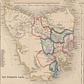
Van Diemen's Land 1852. South West Tasmania was one of the last areas to be explored.
-
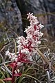
Dracophyllum milliganii
-
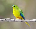
Orange-bellied parrot, Melaleuca Lagoon


See also
 In Spanish: Parque nacional del Suroeste para niños
