Geeveston facts for kids
Quick facts for kids GeevestonTasmania |
|
|---|---|

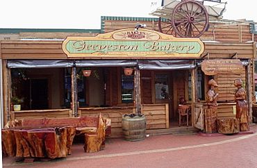
Old Mill Geeveston Bakery with wood carvings
|
|
| Population | 616 (2016 census) |
| • Density | 23.7/km2 (61/sq mi) |
| Established | 1842 |
| Postcode(s) | 7116 |
| Elevation | 115 m (377 ft) |
| Area | 60.2 km2 (23.2 sq mi) |
| Location | |
| LGA(s) | Huon Valley Council |
| State electorate(s) | Franklin |
| Federal Division(s) | Franklin |
Geeveston is a small town in southern Tasmania, Australia. It's located near the Huon River. The town is about 62 kilometers (38 miles) southwest of Hobart. This makes it Australia's most southerly town with a local government office.
The town is named after William Geeves. He was an English settler. Lady Jane Franklin gave him land here in 1842. The area was first called Lightwood Bottom. This was because of a type of timber found there. The settlement William Geeves started was renamed Geeves Town in 1861. Later, it became known as Geeveston.
Geeveston is on the Huon Highway. It is also known as the gateway to the beautiful Hartz Mountains National Park. The town is a major center for Tasmania's apple and fruit-growing industry. For a long time, it has also relied on the timber industry. A large wood pulp mill opened in Geeveston in 1962. It was the town's biggest employer. However, the mill closed in 1982. This caused a difficult time for the town's economy.
Today, the Geeveston Town Hall Visitor Centre helps tourists. It shares information about the local area. It also highlights fun places to visit in southern Tasmania. From 2016 to 2021, the town was even used for filming the comedy TV series Rosehaven.
A Look Back: Geeveston's History
The first post office in the area opened on June 1, 1876. It was called Geeves-Town Post Office. In 1888, its name was officially changed to Geeveston.
Understanding Geeveston's Climate
Geeveston has a pleasant oceanic climate. This type of climate is common in southeastern Tasmania. It means the summers are usually warm. The winters are cool but not too cold.
Sometimes, very hot air comes from Central Australia. This can cause extremely hot weather. It also creates dangerous bushfire conditions. Geeveston gets more rain than Hobart. This is because Tasmania's southern mountains don't block as much moisture-carrying wind.
The wettest month on record was October 1988. It had 296.6 millimeters (11.68 inches) of rain. The driest month was January 1999. It only had 4.8 millimeters (0.19 inches) of rain. The hottest day ever recorded was January 4, 2013. The temperature reached 40 degrees Celsius (104 degrees Fahrenheit). The coldest morning was June 19, 1992. The temperature dropped to minus 5.2 degrees Celsius (22.6 degrees Fahrenheit).
| Climate data for Geeveston Cemetery Road (1971–2015) | |||||||||||||
|---|---|---|---|---|---|---|---|---|---|---|---|---|---|
| Month | Jan | Feb | Mar | Apr | May | Jun | Jul | Aug | Sep | Oct | Nov | Dec | Year |
| Record high °C (°F) | 40.0 (104.0) |
36.9 (98.4) |
36.8 (98.2) |
29.8 (85.6) |
25.0 (77.0) |
20.6 (69.1) |
18.9 (66.0) |
23.7 (74.7) |
27.7 (81.9) |
31.0 (87.8) |
34.0 (93.2) |
37.0 (98.6) |
40.0 (104.0) |
| Mean daily maximum °C (°F) | 21.8 (71.2) |
22.1 (71.8) |
20.1 (68.2) |
17.2 (63.0) |
14.6 (58.3) |
12.3 (54.1) |
12.1 (53.8) |
13.0 (55.4) |
14.8 (58.6) |
16.4 (61.5) |
18.3 (64.9) |
19.9 (67.8) |
16.9 (62.4) |
| Mean daily minimum °C (°F) | 10.0 (50.0) |
9.9 (49.8) |
8.5 (47.3) |
6.3 (43.3) |
4.7 (40.5) |
2.4 (36.3) |
2.2 (36.0) |
3.0 (37.4) |
4.5 (40.1) |
6.0 (42.8) |
7.6 (45.7) |
8.7 (47.7) |
6.1 (43.1) |
| Record low °C (°F) | 0.8 (33.4) |
0.1 (32.2) |
−1.2 (29.8) |
−2.8 (27.0) |
−3.7 (25.3) |
−5.2 (22.6) |
−4.5 (23.9) |
−4.4 (24.1) |
−4.6 (23.7) |
−1.4 (29.5) |
0.0 (32.0) |
1.0 (33.8) |
−5.2 (22.6) |
| Average rainfall mm (inches) | 57.2 (2.25) |
49.2 (1.94) |
54.7 (2.15) |
63.6 (2.50) |
73.6 (2.90) |
72.4 (2.85) |
92.7 (3.65) |
104.6 (4.12) |
93.1 (3.67) |
92.2 (3.63) |
69.4 (2.73) |
70.5 (2.78) |
893.2 (35.17) |
| Average rainy days | 13.2 | 12.2 | 14.3 | 13.5 | 13.6 | 11.4 | 13 | 14.4 | 14.7 | 13.7 | 16 | 13.7 | 163.7 |
| Average relative humidity (%) | 73 | 75 | 77 | 78 | 80 | 82 | 80 | 79 | 76 | 74 | 75 | 73 | 77 |
 | Roy Wilkins |
 | John Lewis |
 | Linda Carol Brown |


