
West Coast Range facts for kids
Quick facts for kids West Coast Range |
|
|---|---|

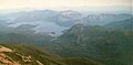
The West Coast Range, viewed from the air in 2016.
|
|
| Highest point | |
| Peak | Mount Murchison |
| Elevation | 1,275 m (4,183 ft) AHD |
| Geography | |

Location in Tasmania
|
|
| Country | Australia |
| State | Tasmania |
| Range coordinates | 42°05′24″S 145°36′00″E / 42.09000°S 145.60000°E |
| Geology | |
| Type of rock | Dolerite |
The West Coast Range is a group of mountains found in the West Coast area of Tasmania, Australia. It's a really important place because of its rich natural resources and interesting history.
This mountain range is located west and north of the main parts of the Franklin-Gordon Wild Rivers National Park. It runs from north to south, following a line of ancient volcanoes called the Mount Read volcanic arc.
The West Coast Range has been used for many different things over time. People have built Hydro Tasmania dams here to create electricity. There have also been many mines because the area is full of valuable minerals. The range also contains important transport routes and historical sites. Today, Gormanston is one of the few towns still active within the range itself.
Contents
Exploring the West Coast Range
The features of the West Coast Range are shaped by how glaciers moved in the past and by the range's north-south direction.
Mountains of the Range
The West Coast Range is home to many mountains, including some smaller groups of peaks. Here are some of the main ones:
| Rank | Name | Height | Location | Prominence | Notes |
|---|---|---|---|---|---|
| 1 | Mount Murchison | 1,275 metres (4,183 ft) | 41°48′00″S 145°36′36″E / 41.80000°S 145.61000°E | 760 metres (2,493 ft) | |
| 2 | Mount Geikie (Tyndall Range) | 1,191 metres (3,907 ft) | 41°58′12″S 145°34′12″E / 41.97000°S 145.57000°E | ||
| 3 | Mount Tyndall (Tyndall Range) | 1,179 metres (3,868 ft) | 41°55′48″S 145°35′24″E / 41.93000°S 145.59000°E | ||
| 4 | Mount Jukes | 1,168 metres (3,832 ft) | 42°10′12″S 145°34′48″E / 42.17000°S 145.58000°E | 911 metres (2,989 ft) | |
| 5 | Mount Sedgwick | 1,147 metres (3,763 ft) | 42°00′00″S 145°36′36″E / 42.00000°S 145.61000°E | ||
| 6 | Mount Owen | 1,146 metres (3,760 ft) | 42°05′24″S 145°36′00″E / 42.09000°S 145.60000°E | 774 metres (2,539 ft) | |
| 7 | Mount Sorell | 1,144 metres (3,753 ft) | 42°16′12″S 145°32′24″E / 42.27000°S 145.54000°E | 673 metres (2,208 ft) | |
| 8 | Mount Dundas | 1,143 metres (3,750 ft) | 41°53′24″S 145°28′12″E / 41.89000°S 145.47000°E | ||
| 9 | Mount Read | 1,124 metres (3,688 ft) | 41°50′24″S 145°32′24″E / 41.84000°S 145.54000°E | ||
| 10 | Proprietary Peak | 1,103 metres (3,619 ft) | 42°09′36″S 145°34′38″E / 42.16000°S 145.57722°E | ||
| 11 | Pyramid Peak | 1,080 metres (3,543 ft) | 42°11′24″S 145°34′48″E / 42.19000°S 145.58000°E | ||
| 11 | Sticht Range (unnamed peak) | 1,080 metres (3,543 ft) | 41°54′S 145°39′E / 41.900°S 145.650°E | ||
| 13 | West Jukes Peak | 1,062 metres (3,484 ft) | 42°10′48″S 145°34′12″E / 42.18000°S 145.57000°E | ||
| 14 | Mount Darwin | 1,033 metres (3,389 ft) | 42°15′00″S 145°35′48″E / 42.25000°S 145.59667°E | ||
| 15 | South Jukes Peak | 1,014 metres (3,327 ft) | 42°11′24″S 145°34′38″E / 42.19000°S 145.57722°E | ||
| 16 | Mount Hamilton | 1,005 metres (3,297 ft) | 41°50′24″S 145°30′36″E / 41.84000°S 145.51000°E | ||
| 17 | Mount Black | 950 metres (3,117 ft) | 41°45′36″S 145°33′36″E / 41.76000°S 145.56000°E | ||
| 18 | Victoria Peak | 949 metres (3,114 ft) | 41°47′24″S 145°40′12″E / 41.79000°S 145.67000°E | ||
| 19 | Mount Huxley | 926 metres (3,038 ft) | 42°08′24″S 145°35′24″E / 42.14000°S 145.59000°E | ||
| 20 | Mount Lyell | 920 metres (3,018 ft) | 42°03′00″S 145°36′36″E / 42.05000°S 145.61000°E | ||
| 21 | Mount Strahan | 855 metres (2,805 ft) | 42°14′24″S 145°30′36″E / 42.24000°S 145.51000°E | ||
| 22 | Mount Julia | 843 metres (2,766 ft) | 41°52′48″S 145°33′36″E / 41.88000°S 145.56000°E | ||
| 23 | South Darwin Peak | 780 metres (2,559 ft) | 42°17′24″S 145°34′48″E / 42.29000°S 145.58000°E | ||
| 24 | Mount Selina | 760 metres (2,493 ft) | 41°52′12″S 145°37′12″E / 41.87000°S 145.62000°E | ||
| 25 | Mount Farrell | 711 metres (2,333 ft) | 41°45′00″S 145°37′48″E / 41.75000°S 145.63000°E |
Other Hills and Features
- Darwin Crater - This is a hole in the ground likely made by a meteorite hitting Earth. It's linked to a special type of glass called Darwin glass.
- Gooseneck Hill
- Henty Glacial Moraine - A pile of rocks and dirt left behind by a glacier.
- Marble Bluff - A cliff near where the Eldon and South Eldon rivers meet. It's also at the northern edge of Lake Burbury.
- Teepookana Plateau
- Thureau Hills - These hills are next to the eastern slopes of Mount Owen and Mount Huxley.
- Walford Peak - This peak is next to Lake Dora.
Rivers Flowing Through the Range
- Anthony River - In the northern part of the range.
- Bird River - At the southern end of the range.
- Eldon River - On the eastern side of the range.
- Governor River - Also on the eastern side.
- Henty River - On the western side of the range.
- King River - Starts in the Eldon Range and flows between Mount Huxley and Mount Jukes. It's dammed by The Hydro.
- Mackintosh River
- Murchison River
- Pieman River
- Queen River - Flows through Queenstown and joins the King River.
- Sophia River
- South Eldon River
- Tofft River - Runs between the Thureau hills and Mount Owen and Mount Huxley.
- Yolande River - Located between Lake Margaret and the Henty River.
Lakes in the West Coast Range
- Basin Lake - On the western side of the range.
- Lake Adam - Feeds into Lake Margaret.
- Lake Barnabas
- Lake Beatrice - On the eastern edge of Mount Sedgwick.
- Lake Burbury - Formed when the King River was dammed by The Hydro.
- Lake Dora
- Lake Dorothy
- Lake Huntley - On the eastern side of Mount Tyndall.
- Lake Julia - In an area of the range called 'The Tyndalls'.
- Lake Mackintosh - Formed by damming the Mackintosh River.
- Lake Magdala - Feeds into Lake Margaret.
- Lake Martha - Feeds into Lake Margaret.
- Lake Mary, Tasmania - Feeds into Lake Margaret.
- Lake Margaret - On the northern side of Mount Sedgwick.
- Lake Monica - Feeds into Lake Margaret.
- Lake Murchison - Formed by damming the Murchison River.
- Lake Myra - Feeds into Lake Margaret.
- Lake Paul - Feeds into Lake Margaret.
- Lake Peter - Feeds into Lake Margaret.
- Lake Philip - Feeds into Lake Margaret.
- Lake Plimsoll
- Lake Polycarp - Feeds into Lake Margaret.
- Lake Rolleston - Between the Tyndall Range and the Sticht Range.
- Lake Selina - Just west of Lake Plimsoll.
- Lake Spicer - Just west of Eldon Peak.
- Lake Tyndall - South of Mount Tyndall.
- Lake Westwood - Next to Mount Julia.
Protected Areas
- Mount Farrell Regional Reserve
- Mount Murchison Regional Reserve
- Tyndall Regional Reserve
- Lake Beatrice Conservation Area
- Princess River Conservation Area
- Crotty Conservation Area
- West Coast Range Regional Reserve (Clark River Valley)
Plants and Trees
The slopes of mountains like Mount Owen, Mount Lyell, and Mount Sedgwick have many tree stumps. These are from forests that were destroyed by fires and smoke from smelters in the early 1900s. The damage to forests near mining areas like Queenstown started as early as the 1890s and continued for a long time.
Some very old Huon Pine trees have been found on the slopes of Mount Read.
Because of fires, mining, and other human activities, most of the plant life along the West Coast Range has changed. Only a few small areas remain untouched since Europeans arrived.
The eastern side of the range borders the Franklin-Gordon Wild Rivers National Park. Here, the forests are in much better condition. There are also special zones to protect forests along the range, following an agreement called the Regional Forestry Agreement (RFA).
Weather in the West Coast Range
In winter, most of the mountains above 1,000 meters are covered in snow. The Mount Read automatic weather station now records extreme weather conditions regularly. This area gets a lot of rain, about 2800–3000 mm (110–118 inches) each year.
The weather here is strongly affected by the West Coast's location. There's no land to block the winds and storms coming from the Southern Ocean or Antarctic. Because it's in the "Roaring Forties" (a windy zone around 40 degrees south latitude), cold fronts and extreme weather happen often.
History and Exploration
Early European explorers and even convicts escaping from Macquarie Harbour Penal Station on Sarah Island explored the West Coast Range. Most of this exploration happened in the late 1800s. Even in the 1940s, some government maps still marked parts of the range as "unexplored."
Many of the mountains visible from Macquarie Harbour were named after people involved in the scientific discussions around Charles Darwin's ideas in the late 19th century.
Thomas Bather Moore named Mount Darwin, Mount Geikie, Mount Read, and the Tyndall Range. Charles Gould named Mount Murchison, Mount Sedgwick, Mount Lyell, and Mount Owen between 1860 and 1862. Mount Huxley and Mount Jukes were named later.
There were small mining towns on Mount Darwin and Mount Jukes, and possibly temporary camps in other places. Linda, in the Linda Valley, is one of the few remaining populated places within a valley in the range. Queenstown is located in the Queen River valley, on the western slopes of Mount Owen or the southwestern slopes of Mount Lyell, and is considered just outside the main range.
Mining in the Mountains
The West Coast region of Tasmania is famous for its rich mineral deposits. Many valuable minerals like Barium, Copper, Gold, Pyrites, Silver, and Zinc have been found here.
Mining sites, often short-lived, existed on the higher parts of Mount Darwin and Mount Jukes. Longer-lasting mines were found on the middle slopes of Mount Lyell and on the middle and upper slopes of Mount Read. People have explored for minerals on almost all the named mountains over time.
Today, there are special rules to protect the environment when mining, to avoid the kind of damage that happened with the Mount Lyell operation in the past. The Henty Gold Mine, at the northern end of the range, is a good example of mining done carefully in a sensitive area.
Hydroelectric Dams
The West Coast of Tasmania has always been a good place for building dams to create hydroelectricity. Plans for dams on the King River were made as early as World War I.
In the 1950s and early 1960s, surveys for dams began. The Pieman scheme dammed parts of the West Coast Range. The last big dam projects by the Hydro-Electric Commission (HEC) were the Henty and King River Schemes.
Pieman River Scheme
The Pieman River Power Scheme involved building dams on rivers that start in the West Coast Range. This project followed the Gordon River Scheme.
Construction started in 1974 and finished in 1987. It included dams on the Murchison and Mackintosh rivers, as well as the Pieman River itself. The main town for building and managing the Hydro projects was Tullah.
The Mackintosh Dam and power station are north of Tullah. The Murchison Dam and Lake are to the south. Another dam, the Bastyan Dam, is just north of Rosebery. The Reece Dam is further west, near the town of Corinna.
King River Scheme
The Crotty Dam is a large dam, 82 meters (269 feet) high, built by Hydro Tasmania on the King River. It's located between Mount Huxley and Mount Jukes. The Darwin Dam is a smaller dam at the base of Mount Darwin. Both dams help create Lake Burbury, a large water storage area covering 54 square kilometers (21 square miles).
Getting Around the Range
In the past, people reached the West Coast region by walking or by sea. Railways were built into the area much earlier than roads. The road from Hobart wasn't connected until the 1930s, and the road from the north coast wasn't finished until the 1960s.
Railways
Railways were built to support the Mount Lyell and North Mount Lyell mines. They connected the mines to ports on Macquarie Harbour but did not cross the mountain range.
- North Mount Lyell Railway - Its port was at Pillinger in Kelly Basin.
- Mount Lyell Railway - Its port was at Regatta Point.
Other railway lines, like the North East Dundas Tramway, also went to the base of the mountains where mines were active, but they didn't go over the range.
Roads
The Lyell Highway connects through the West Coast Range in the Linda Valley. This road was built in the 1930s.
The road to Crotty from Queenstown (also known as Lynchford) was built by the Hydro as the Mount Jukes Road in the 1980s. It goes high above the King River Gorge on the northern side of Mount Jukes.
The Anthony Road, also built by the Hydro, cuts through the northern part of the range. It provides access to glacial lakes in The Tyndalls, such as Lake Westwood, Lake Selina, and Lake Julia.
Historical Places and Sites
Old Tramways and Railways
- Comstock Tram - A tramway around the slopes of Mount Lyell.
- Lake Margaret Tram - On the western side of Mount Sedgwick.
- North Mount Lyell Railway - Ran through Linda Valley, along the King River Valley, and past the towns of Crotty and Darwin to Pillinger and Kelly Basin.
Historic Towns
- Crotty - On the eastern slopes of Mount Jukes.
- Darwin - On the eastern slopes of Mount Darwin.
- Gormanston - On the northern slopes of Mount Owen.
- Lake Margaret - An area with a power station and related buildings.
- Linda - In the Linda Valley between Mount Owen and Mount Lyell.
- Tullah - Located near Lake Rosebery.
- Rosebery
- Williamsford
Mine Sites
- Henty Gold Mine
- Mount Jukes Mine sites - Mines on the upper slopes, including the 'Lake Jukes Mine'.
Hydroelectric Sites
- Anthony Power Station
- Bastyan Power Station
- Crotty Dam
- Darwin Dam
- John Butters Power Station
- Lake Margaret Power Station
Main Roads
- Lyell Highway [A10] - Runs through the Linda Valley between Mount Owen and Mount Lyell.
- The Henty River Rd [B24] - Goes from Henty Glacial Moraine to the Lake Murchison Dam (Anthony Power Station) and Tullah.
Walking Trails
Many old walking tracks were created in the 1800s and 1900s. Some are still used today, while others have become overgrown. A famous track maker was Thomas Bather Moore, who named many features like Mount Strahan, the Thureau Hills, and the Tofft River.
Images for kids
-
The West Coast Range, viewed from the air in 2016.
See also
 In Spanish: Cadena de la costa Oeste para niños
