
Mount Huxley (Tasmania) facts for kids
Quick facts for kids Mount Huxley |
|
|---|---|

Mount Huxley, taken from the Queenstown airport
|
|
| Highest point | |
| Elevation | 926 m (3,038 ft) |
| Geography | |

Mount Huxley
Location in Tasmania
|
|
| Location | West Coast, Tasmania, Australia |
| Parent range | West Coast Range |
| Topo map | Owen: 3833 |
Mount Huxley is a mountain located in the West Coast region of Tasmania, Australia. It is part of the West Coast Range. This mountain stands 926 metres (3,038 ft) (about 3,038 feet) above sea level. It was named in 1863 by Charles Gould. He named it after Professor Thomas Henry Huxley, a famous scientist.
Mount Huxley is one of the smaller peaks in the West Coast Range. It has a large rock face about 200-metre (660 ft) (656 feet) tall on its southern side. This rock face is above the King River Gorge. You can see parts of it from the West Coast Wilderness Railway as it follows the King River.
Where is Mount Huxley?
Mount Huxley is located north of the King River Gorge and the Crotty Dam. It is also north of Mount Jukes. To its west are the Tofft River, the Thureau Hills, and Lake Burbury. To the south, you'll find Mount Owen and Queenstown.
You can reach the mountain by a rough track from the north. Another track approaches from the south, near the Queenstown area. The southern side of the mountain is a very steep cliff that drops into the King River Gorge.
A Brief Goldfield History
Between April and June 1894, there was a goldfield on the slopes of Mount Huxley. A group of people formed a syndicate (a business group) that was found to have "salted" the mine site. This means they secretly added gold to the mine to make it look richer than it was. This was done to trick others into investing money.
Even though it was clear the mine had been faked, there wasn't enough proof to take action against the people involved. So, the case was closed.
Images for kids
-
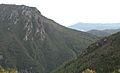
Mount Huxley showing rocky outcrop on the south face above the King River Gorge.
-
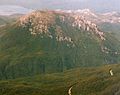
Mount Huxley from the air – from the southwest, and higher than picture at top.
-
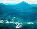
Mount Huxley from the air – from the west northwest from above the old Queenstown landing strip, circa 1975.
-
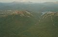
Mount Huxley from the air, at left, King River Gorge centre, Mount Jukes Highway to right, and Lake Burbury and the Crotty Dam at rear.


