Crotty, Tasmania facts for kids
Quick facts for kids CrottyTasmania |
|
|---|---|
| Abolished | circa 1903 |
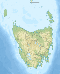
Crotty was once a small town in Western Tasmania, Australia. It was located near the King River, close to Mount Jukes and the West Coast Range. The area was first known as King River.
A Town Appears
Crotty officially became a town on June 5, 1900. Its layout was planned out by November of the same year. By 1902, Crotty was growing fast. It had over 150 homes and about 700 people living there. The last people left Crotty in 1928.
A bridge called the Baxter River bridge was very important for the town. It helped people travel between different railway stops.
Smelters and Railways
Around the year 1900, Crotty had a smelter and a railway line. The smelter was a factory that melted down metal ores. The railway connected Crotty to the North Mount Lyell mine.
However, the smelters at North Mount Lyell had problems. They tried to fix them in 1901 and 1902, but they didn't work well. Because of this, the company that owned the smelters was taken over by the Mount Lyell Mining and Railway Company in 1903.
After the smelters failed, many people started to leave Crotty. The North Mount Lyell Railway, which linked Crotty to places like Gormanston, Linda, and Pillinger, kept running for about 20 more years before it also closed.
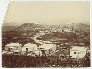
Old photos of Crotty often show the smelters, hotels, and small houses. One famous photo from 1902, found in Geoffrey Blainey's book The Peaks of Lyell, shows smoke from the smelter and Mount Jukes in the background.
Crotty Today
In the 1980s, a camp for dam construction workers was set up in the Crotty area. It was called the Hydro Crotty Camp.
In the 1990s, the old townsite of Crotty was covered by water. This happened when Lake Burbury was formed after the Crotty Dam was built. The dam was part of the King River Power development scheme. Even though it's underwater, maps still show the "Proclaimed Town of Crotty." In 2016, Lake Burbury's water level dropped very low, and some parts of the old town became visible again.
Today, the land south of the Lyell Highway, near the Franklin-Gordon Wild Rivers National Park, is called the Crotty Conservation Area. This special area was created on December 27, 2000, and covers about 44.2 square kilometers.
 | DeHart Hubbard |
 | Wilma Rudolph |
 | Jesse Owens |
 | Jackie Joyner-Kersee |
 | Major Taylor |


