Frenchmans Cap facts for kids
Quick facts for kids Frenchmans Cap |
|
|---|---|
| trullennuer or mebbelek | |

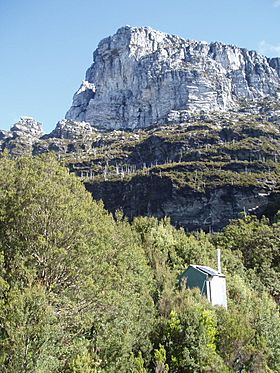
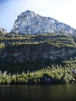
View of Frenchmans Cap from near Lake Tahune Hut
|
|
| Highest point | |
| Elevation | 1,446 m (4,744 ft) |
| Prominence | 966 m |
| Geography | |
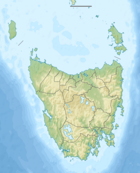
| Location | Western Tasmania, Australia |
| Parent range | West Coast Range |
| Geology | |
| Age of rock | Jurassic |
| Climbing | |
| First ascent | James Sprent (European; 1853) |
Frenchmans Cap is a famous mountain in the West Coast area of Tasmania, Australia. It stands tall in the Franklin-Gordon Wild Rivers National Park.
This mountain is 1,446 metres (4,744 ft) (about 4,744 feet) above sea level. It is one of the thirty highest mountains in all of Tasmania.
Contents
Where is Frenchmans Cap?
This amazing mountain is located east of the West Coast Range. You can see it from far away, even from Macquarie Harbour. It is south of the Lyell Highway, a main road where you can get great views. It is also southwest of the Cradle Mountain-Lake St Clair National Park.
The Frenchmans Cap area has several peaks. These include Frenchmans Cap itself (1,443 metres (4,734 ft)), Clytemnestra (1,280 metres (4,200 ft)), and Philps Peak (1,280 metres (4,200 ft)). There is also Philps Ridge, which is about 1,200 metres (3,900 ft) high.
How Frenchmans Cap Got Its Name
Frenchmans Cap is on the traditional lands of the Aboriginal Tasmanians. They likely belonged to the Toogee nation. The traditional names for this mountain are trullenuer, toindy, or mebbelek.
Sailors on the west coast used the peak as a landmark a long time ago. The name "Frenchmans Cap" was first written down in 1822. This was when it was seen from the Macquarie Harbour Penal Station. People think the mountain got its name because it looks like a Frenchman's cap. This is especially true for the Liberty cap worn during the French Revolution (1789–1799).
Another idea came from Henry Widdowson in 1829. He wrote that the name came from the mountain often being covered in snow. He thought it looked like the hat a French cook would wear.
History of Frenchmans Cap
The mountain's unique shape helped many people find their way. Escaping convicts often used it as a guide. They tried to get through the thick bush of Western Tasmania to safer areas. The convict Alexander Pearce mentioned it as a landmark after he was caught.
The first European to climb Frenchmans Cap was James Sprent. He reached the top with his team in 1853.
In 1941, the Frenchmans Cap National Park was created. Its border was mainly the Franklin River. Later, in the 1990s, this park became part of the larger Franklin-Gordon Wild Rivers National Park.
How to Visit Frenchmans Cap
Most people visit Frenchmans Cap by going on a multi-day hike. The hike starts from the Lyell Highway. The Tasmania Parks and Wildlife Service gives advice on how to prepare for this trip. The weather in the area can change quickly.
The walking track can often become overgrown because of the plants and heavy rain.
The hike to the peak usually takes two days. The first day is about 16 kilometres (9.9 mi) (10 miles) long. It takes walkers to Lake Vera Hut. There is plenty of fresh, drinkable water all year round. The walk from the Lyell Highway to Lake Vera takes about six to eight hours.
This first part of the walk used to be very hard. It had two steep climbs and muddy areas called the "Sodden Loddons." The mud could be very deep! But since 2013, the track has been improved. Parts of it now have wooden walkways. The trail also goes around the muddiest sections. These upgrades have made the first day much easier. They also helped the environment recover. A kind person named Dick Smith helped pay for these improvements.
The second day's walk is shorter, about 9 kilometres (5.6 mi) (5.6 miles). But it is much steeper! After walking along Lake Vera, you will spend two hours climbing to Barron Pass. From there, you get an amazing view of Frenchmans Cap. It takes about two more hours from Barron Pass to Tahune Hut. Water can be hard to find between Barron Pass and Lake Tahune. The walk from Lake Vera to Lake Tahune takes about four hours.
There are two lakes on the way to the summit: Lake Vera and Lake Tahune. Both have huts where hikers can stay. Lake Vera Hut was built in 1979. It can sleep 20 people and has a coal stove for heat.
Three huts have been built at Lake Tahune. The first was built after World War II but burned down in 1966. The second hut was finished in 1971. It could sleep 16 people and had a coal stove. In 2018, a new hut, Tahune #3, replaced it. This new hut is very well-designed and uses hydro-electric power for heat. It can sleep 24 people comfortably. Dick Smith also helped fund this hut.
From Tahune Hut, it takes about 2.5 hours to walk to the summit and back. You should only try this if the weather is clear. If the weather is good, you can see the West Coast beaches and Lake Burbury. You can also see many other peaks, like Tasmania's tallest, Mount Ossa. These are all in the Cradle Mountain-Lake St Clair National Park.
The total hike to Frenchmans Cap is about 50-kilometre (31 mi) (31 miles) round trip. You usually go back on the same track.
Other Ways to Access the Mountain
You can also make the trip a round journey. From Lake Tahune, you can walk to the Franklin River at Irenabyss. Then you cross the river and exit at Victoria Pass, which is also on the Lyell Highway. This walk from Irenabyss to Victoria Pass is very tough. It is only for hikers with a lot of experience. Many people visit Irenabyss as a long day trip. The walk from Lake Tahune to Irenabyss takes about 4 hours. From Irenabyss to Victoria Pass takes about 12 hours.
Climbing Frenchmans Cap
For rock climbers, Frenchmans Cap has many trad routes. These climbs are on strong, quartzite rock. Some of these climbs have French names, like the A Toi La Gloire (also known as The Sydney Route). This climb is 380-metre (1,250 ft) long and has 13 sections. Another is Tierry Le Fronde, which is 150-metre (490 ft) long with six sections.
People have been doing serious climbing here since the 1960s.
Frenchmans Cap in Art and Books
Frank Hurley took many famous black and white photos of Frenchmans Cap in the 1950s. You can find these pictures in the National Library online collection. They show the area around the mountain very well.
Frenchmans Cap is also mentioned in books. Barry Maitland's 2008 mystery novel Bright Air describes a climb of the mountain. It also appears in For the Term of His Natural Life by Marcus Clarke. Another book is Hell's Gates: The terrible journey of Alexander Pearce, Van Diemen's Land cannibal by Paul Collins. Simon Kleinig also wrote a book about it in 2012.
 | Emma Amos |
 | Edward Mitchell Bannister |
 | Larry D. Alexander |
 | Ernie Barnes |


