Recherche Bay facts for kids
Quick facts for kids Recherche Bay(Leillateah) |
|
|---|---|

A beach on Recherche Bay near Cockle Creek
|
|
| Location | Southern Tasmania |
| Coordinates | 43°32′S 146°54′E / 43.533°S 146.900°E |
| Etymology | Recherche |
| Ocean/sea sources | Southern Ocean |
| Basin countries | Australia |
| Designation | Australian National Heritage List |
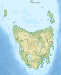
Recherche Bay (pronounced REE-sertch) is a beautiful bay in the very south-east of Tasmania, Australia. Part of the bay is so special that it's listed on the Australian National Heritage List. This means it's a very important place for Australia's history and nature.
The bay was a key landing spot for a French expedition led by Bruni d'Entrecasteaux. They were searching for another explorer, Jean-François de Galaup, comte de Lapérouse, who had gone missing. The bay is named after one of their ships, the Recherche. The local Aboriginal people, the Nuenonne, call the bay Leillateah.
Contents
French Explorers Visit Recherche Bay
In the late 1700s, French explorers visited Recherche Bay twice. They stayed for about a month each time, in April 1792 and January 1793. Their main goal was to find a safe place to rest and get more supplies. But they also spent a lot of time doing scientific research.
Scientific Discoveries at the Bay
The expedition included several botanists, who are scientists who study plants. These botanists, like Jacques Labillardière, collected and cataloged nearly 5,000 different plant samples. One important plant they found was the blue gum, also known as Eucalyptus globulus. This tree later became the official plant symbol of Tasmania.
The French explorers also set up a special scientific observatory at Recherche Bay. This was the first time a planned scientific experiment was done on Australian land. A scientist named Elisabeth Paul Edouard de Rossel measured the Earth's magnetic field. He proved that the strength of the magnetic field changes depending on how far north or south you are.
Friendly Meetings with Aboriginal People
During their second visit in 1793, the French explorers met the Tasmanian Aboriginal people living in the area. They had friendly interactions, which was an important part of their journey.
Recherche Bay After British Settlement
After the British started settling in Van Diemen's Land (which is now Tasmania), Recherche Bay remained quite isolated. It was far from the main towns and had strong easterly winds. The land was also not very good for farming, so not many European settlers moved there.
The Cyprus Mutiny
In 1829, something exciting happened at Recherche Bay. A ship called the Cyprus was carrying convicts from Hobart to a prison in Macquarie Harbour. Some of the convicts took over the ship in a mutiny. They left the officers, soldiers, and other convicts on shore without supplies.
The mutineers then sailed the Cyprus all the way to Canton in China. There, they sank the ship and pretended to be shipwrecked sailors from another vessel. On their way to China, the Cyprus even visited Japan. This was during a time when Japan had very strict rules about foreigners entering the country.
Later Activities at the Bay
In the 1830s and 1840s, Recherche Bay became a busy place for whaling. There were up to five whaling stations where people hunted whales. The bay was also used by pilots who guided ships through the D'Entrecasteaux Channel. Whaling ships often used the bay for shelter during bad weather or to process whales.
Sadly, two whaling ships, the Maria Orr in 1846 and the Offley in 1880, were wrecked in gales at the bay. Later in the 19th and early 20th centuries, the main activities shifted. People started gathering timber, mostly around the town of Leprena. Coal mining also became important, mainly near the town of Catamaran. A large old ship, the James Craig, was even used there to store coal.
Images for kids
 | Aurelia Browder |
 | Nannie Helen Burroughs |
 | Michelle Alexander |


