River Derwent (Tasmania) facts for kids
Quick facts for kids River Derwent |
|
|---|---|

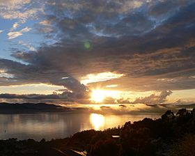
Sunrise over the River Derwent
|
|
|
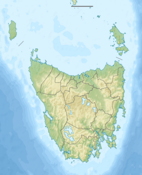
Location of the river mouth in Tasmania
|
|
| Native name | timtumili minanya |
| Other name(s) | timtumili minanya |
| Country | Australia |
| State | Tasmania |
| Cities | Derwent Bridge, New Norfolk, Hobart |
| Physical characteristics | |
| Main source | Lake St Clair Central Highlands |
| River mouth | Storm Bay Hobart 0 m (0 ft) 43°3′3″S 147°22′38″E / 43.05083°S 147.37722°E |
| Length | 239 km (149 mi) |
| Basin features | |
| Basin size | 9,832 km2 (3,796 sq mi) |
| Tributaries |
|
| Natural lakes | Saint Clair Lagoon; Lake Saint Clair |
The River Derwent is an important river in Tasmania, Australia. It is also known by its traditional name, timtumili minanya, from the palawa kani language. The river starts high up in Tasmania's Central Highlands at Lake St Clair.
It flows downhill for over 700 metres (2,300 ft) and travels more than 200 kilometres (120 mi). The Derwent passes through Hobart, which is Tasmania's capital city. Finally, it flows into Storm Bay and then into the Tasman Sea. Long ago, the river banks were covered in forests and were home to Tasmanian Aboriginal people. Later, European settlers used the land for farming. In the 1900s, many dams were built on the river's smaller streams to create electricity from water power.
Today, the land around the Derwent is used for farming, growing trees, making hydropower, and raising fish. The river is also a key source of water for watering crops and for people to drink. Most of Hobart's drinking water comes from the lower part of the River Derwent. About 40% of Tasmania's population lives near the river's mouth. People enjoy the Derwent for fun activities like boating, fishing, and transport.
Contents
The Name of the River Derwent
The River Derwent was named by a British explorer named John Hayes in 1793. He named it after the River Derwent, Cumbria in England, which was near his hometown. The name "Derwent" comes from an old Celtic language. It means "valley thick with oaks," referring to a place with many oak trees.
John Hayes first used the name only for the upper part of the river. Later, another explorer, Matthew Flinders, used the name "Derwent River" for the entire river.
History of the Derwent Valley
The valley of the River Derwent was home to the Mouheneener people for at least 8,000 years. This was long before British settlers arrived. We know this from many shell mounds, called middens, found along the river banks. These middens show where the Aboriginal people lived and ate.
When Europeans first explored the area, the lower parts of the valley were covered in thick forests of she-oak trees. Some of these ancient forests can still be seen today. For a time, there was a busy industry catching whales in the river. However, this industry quickly ended around the 1840s because too many whales were caught.
River Derwent Geography
The River Derwent begins where the Narcissus and Cuvier rivers meet inside Lake St Clair. From there, it generally flows southeast for about 187 kilometres (116 mi) to New Norfolk. The part of the river that mixes with the sea, called the estuary, stretches another 52 kilometres (32 mi) out to the Tasman Sea.
The amount of water flowing in the river usually ranges from 50 to 140 cubic metres per second (1,800 to 4,900 cu ft/s). The average flow each year is about 90 cubic metres per second (3,200 cu ft/s). The large estuary forms the Port for the city of Hobart. This port is often said to be the deepest safe harbour in the Southern Hemisphere. Famous ships have visited this port. These include HMS Beagle in 1836, which carried Charles Darwin. Other large ships like the USS Enterprise and USS Missouri have also visited.
The largest ship to ever travel the Derwent was the Diamond Princess. This huge ocean liner weighs 113,000 tonnes (111,000 long tons; 125,000 short tons) and is 61 metres (200 ft) tall. It first visited in January 2006. In some lower parts of the river, it can be almost 3 kilometres (1.9 mi) wide. This makes it the widest river in Tasmania.
Hydroelectric Power Schemes
Before many dams were built between 1934 and 1968, the river often flooded. Now, there are more than twenty dams and reservoirs on the Derwent and its smaller rivers. These are used to create hydro-electricity. Some of these smaller rivers include the Clyde, Dee, Jordan, Nive, Ouse, Plenty, and Styx rivers.
Seven lakes have been formed by damming the Derwent and Nive rivers for power. These include Meadowbank, Cluny, Repulse, Catagunya, Wayatinah, Liapootah, and King William lakes or lagoons.
River Health and Environment
The upper part of the Derwent River is affected by water running off farms. This includes water from cleared land and forestry areas. The lower part of the Derwent has higher levels of certain metals in its mud. The Derwent Estuary Program, supported by the Tasmanian Government, has noted that these metal levels are higher than national safety guidelines.
In 2015, the program suggested not eating shellfish from the river. They also advised caution when eating fish in general. Between 2010 and 2015, nutrient levels increased in the upper estuary. This led to more algal blooms, which are large growths of algae.
Much of the metal pollution came from big industries that used to release waste into the river. These include the former Electrolytic Zinc (now Nyrstar) factory at Lutana, which opened in 1916. A paper mill at Boyer, which started in 1941, also contributed. The Derwent River is connected to important wetlands. These include the Pittwater–Orielton Lagoon, Interlaken Lakeside Reserve, and Goulds Lagoon. These wetlands are protected under the Ramsar Convention because they are so important for nature.
Flora and Fauna in the River Derwent

In recent years, southern right whales have started to return to the river. They appear in winter and spring during their migration. Some female whales have even begun using the calm river waters to give birth to their calves. They stay for weeks after being absent for almost 200 years due to too much whaling.
In the winter of 2014, humpback whales and a minke whale were seen feeding in the River Derwent. This was the first time these species were confirmed in the river since the whaling days of the 1800s.
Bridges Over the Derwent
Several bridges connect the western side of Hobart, which has more people, to the eastern side. In the greater Hobart area, these bridges include:
- The five-lane Tasman Bridge, located near the city center.
- The four-lane Bowen Bridge.
- The two-lane Bridgewater Bridge and Causeway.
Before 1964, the Derwent was crossed by the unique Hobart Bridge. This was a floating concrete bridge, located a bit upstream from where the Tasman Bridge is now.
Further north from the Bridgewater crossing, you'll find the New Norfolk Bridge. This is just north of where the river changes from seawater to fresh water. Other crossings are at Bushy Park, Upper Meadowbank Lake, Lake Repulse Road, Wayatinah, and the most northern crossing at Derwent Bridge. At the Derwent Bridge, the river is usually narrow enough that you can step across it.
Panoramas
See also
 In Spanish: Río Derwent (Tasmania) para niños
 | John T. Biggers |
 | Thomas Blackshear |
 | Mark Bradford |
 | Beverly Buchanan |


