Ulverstone, Tasmania facts for kids
Quick facts for kids UlverstoneTasmania |
|||||||||
|---|---|---|---|---|---|---|---|---|---|

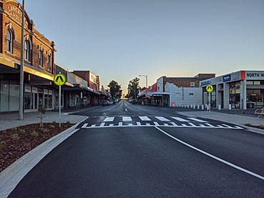
Ulverstone's main street in January 2021
|
|||||||||
| Population | 11,603 (2021) | ||||||||
| Postcode(s) | 7315 | ||||||||
| Location |
|
||||||||
| LGA(s) | Central Coast Council | ||||||||
| State electorate(s) | Braddon | ||||||||
| Federal Division(s) | Braddon | ||||||||
|
|||||||||
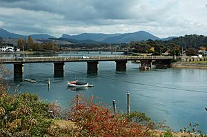
Ulverstone is a town located on the northern coast of Tasmania, Australia. It sits right where the River Leven meets the Bass Strait. You can find it along the Bass Highway. It is about 21 kilometres (13 miles) west of Devonport and 12 kilometres (7.5 miles) east of Penguin.
In June 2021, Ulverstone had a population of 11,613 people. This makes it the largest town in Tasmania. Ulverstone is part of the Central Coast Council area. This area also includes other towns like Penguin, Turners Beach, and Forth.
Contents
Exploring Ulverstone's Past
The first European settlers arrived in the Ulverstone area in 1848. Andrew Risby, his wife Louisa, and their five young children came to start a farm. They cleared land from what was mostly a thick forest.
The Risby family first arrived in Adelaide, South Australia, in 1839 from England. They later moved to Tasmania in 1841, settling near the Forth River. After some years of farming, they moved west to the 'Leven' district. This area was known for its good timber and a climate similar to England. The Risby family settled on land called The Rises. This area is now part of Ulverstone. Some of their family members still live in the district today.
How Ulverstone Grew
During the 1850s, more settlers came to the district. Many timber cutters also visited the area. They cut timber, which was then sold in Melbourne. Melbourne needed a lot of good quality timber during the Victorian gold rush. At first, it was hard for new settlers to buy land. Wealthy people often bought land just to sell it later for more money. But in 1854, new rules made it easier for settlers to live and farm there.
The 'Leven' Post Office opened on May 30, 1857. It was later renamed Ulverstone in 1881. The area's good rainfall and rich soil helped farming grow. Early settlers worked very hard to grow food and earn money from their crops. Ulverstone grew quite fast during the 1890s.
The name Ulverstone was first used in 1854. This was when Hugh Ross McKay opened the Ulverstone store. Ulverstone officially became a town on February 22, 1861. This was declared by Governor H.E. Fox-Young. The town is named after Ulverston in England. That English town also sits at the mouth of a river called Leven.
From 1915 to 1955, a special railway line ran from Ulverstone to Nietta. It mainly carried timber to the Burnie Pulp Mill. This part of Tasmania has very good farming land. This makes the area rich and attractive. More and more retired people are also choosing to live along this coast.
Ulverstone's Weather Patterns
Ulverstone has an oceanic climate. This means it has mild, fairly dry summers and cool, rainy winters. The nearby Bass Strait makes the climate cooler. It also causes a noticeable seasonal lag, meaning the warmest and coldest times happen a bit later than the sunniest and least sunny times.
Temperature and Rainfall
The average highest temperature is about 21.1°C (70°F) in February. The lowest average high is about 11.5°C (52.7°F) in July. The average lowest temperature is around 11.6°C (52.9°F) in February. The lowest average low is about 3.6°C (38.5°F) in July.
Ulverstone gets a moderate amount of rain each year, about 936.5 millimetres (36.9 inches). This rain falls over about 147 days a year. Most of the rain happens in winter. The coldest temperature ever recorded was -3.2°C (26.2°F) on July 17, 1982. The hottest was 30.8°C (87.4°F) on February 7, 1967. This weather information comes from Forthside, a place near Ulverstone.
| Climate data for Ulverstone (41º12'00"S, 146º16'12"E, 127 m AMSL) (1966-1996 normals and extremes, rainfall to 2024) | |||||||||||||
|---|---|---|---|---|---|---|---|---|---|---|---|---|---|
| Month | Jan | Feb | Mar | Apr | May | Jun | Jul | Aug | Sep | Oct | Nov | Dec | Year |
| Record high °C (°F) | 30.2 (86.4) |
30.8 (87.4) |
29.0 (84.2) |
24.0 (75.2) |
19.9 (67.8) |
17.6 (63.7) |
15.8 (60.4) |
16.9 (62.4) |
20.3 (68.5) |
24.1 (75.4) |
28.1 (82.6) |
28.6 (83.5) |
30.8 (87.4) |
| Mean daily maximum °C (°F) | 20.6 (69.1) |
21.1 (70.0) |
19.7 (67.5) |
16.9 (62.4) |
14.4 (57.9) |
12.2 (54.0) |
11.5 (52.7) |
12.1 (53.8) |
13.4 (56.1) |
15.4 (59.7) |
17.1 (62.8) |
18.9 (66.0) |
16.1 (61.0) |
| Mean daily minimum °C (°F) | 11.0 (51.8) |
11.6 (52.9) |
10.4 (50.7) |
8.2 (46.8) |
6.3 (43.3) |
4.1 (39.4) |
3.6 (38.5) |
4.2 (39.6) |
4.9 (40.8) |
6.2 (43.2) |
8.1 (46.6) |
9.6 (49.3) |
7.4 (45.2) |
| Record low °C (°F) | 0.0 (32.0) |
0.9 (33.6) |
1.2 (34.2) |
−2.3 (27.9) |
−2.6 (27.3) |
−2.6 (27.3) |
−3.2 (26.2) |
−2.9 (26.8) |
−2.6 (27.3) |
−2.8 (27.0) |
−0.6 (30.9) |
−0.2 (31.6) |
−3.2 (26.2) |
| Average precipitation mm (inches) | 52.0 (2.05) |
43.6 (1.72) |
56.9 (2.24) |
70.3 (2.77) |
84.6 (3.33) |
95.9 (3.78) |
117.1 (4.61) |
112.6 (4.43) |
89.9 (3.54) |
81.0 (3.19) |
68.6 (2.70) |
64.8 (2.55) |
936.5 (36.87) |
| Average precipitation days (≥ 0.2 mm) | 8.7 | 7.7 | 9.9 | 10.9 | 13.5 | 14.0 | 16.7 | 16.9 | 14.7 | 12.9 | 11.2 | 10.2 | 147.3 |
| Mean monthly sunshine hours | 266.6 | 234.5 | 207.7 | 168.0 | 136.4 | 123.0 | 130.2 | 148.8 | 177.0 | 223.2 | 234.0 | 254.2 | 2,303.6 |
| Percent possible sunshine | 58 | 61 | 54 | 51 | 45 | 44 | 44 | 46 | 50 | 54 | 54 | 54 | 51 |
| Source: Bureau of Meteorology (1966-1996 normals and extremes, rainfall to 2024) | |||||||||||||
Learning in Ulverstone: Schools and Festivals
Ulverstone has several schools for students of all ages.
Primary and Secondary Schools
There are three public primary schools in Ulverstone:
- East Ulverstone Primary School
- Central Ulverstone Primary School
- West Ulverstone Primary School
For older students, there is one public high school:
- Ulverstone Secondary College
Ulverstone also has two private schools:
- Sacred Heart Primary School
- Leighland Christian School
As of 2017, students in Years 11 and 12 can study at Ulverstone Secondary College. They can also travel to Penguin District School in Penguin. Other options include Don College in Devonport or Hellyer College in Burnie.
TastroFest: An Astronomy Celebration
Ulverstone is home to TastroFest, which is Tasmania's Astronomy Festival. This exciting event happens every year in August. It is the largest astronomy festival in Australia! TastroFest focuses on education. It offers programs for both students and the public over three days.
Famous Faces from Ulverstone
Many notable people have connections to Ulverstone. Here are a few:
- Nita Burke (born 1937), an Australian basketball player.
- Noel Carter, an Australian rules footballer.
- Richard Fromberg, a tennis player.
- Kerry Good, an Australian rules footballer.
- Peter Hamilton, an Australian rules footballer.
- John Heathcote, an Australian rules footballer.
- Ben Hilfenhaus, an Australian national and state cricketer.
- Joseph Lyons, who became the Prime Minister of Australia from 1932 to 1939. He lived in Ulverstone during some of his early years. He moved there from Stanley at age 5 and went to school. His family moved back to Stanley when he was 12.
- Frank MacDonald, the last Tasmanian soldier from World War I.
- Karl Menzies, a cyclist.
- David Neitz, an Australian rules footballer.
- Dion Scott, an Australian rules footballer.
- Alex Pearce, an Australian rules footballer.
- Tammy Tyrell, a federal senator.
- Craig Walton, a triathlete and coach.
 | Jewel Prestage |
 | Ella Baker |
 | Fannie Lou Hamer |


