
Macquarie Island facts for kids
|
Nickname: Macca
|
|
|---|---|

Satellite photo of Macquarie Island
|
|

Macquarie Island
Location in Oceania
Location in the Southwestern Pacific Ocean
|
|
| Geography | |
| Location | Southwestern Pacific Ocean |
| Coordinates | 54°38′S 158°52′E / 54.63°S 158.86°E |
| Area | 128 km2 (49 sq mi) |
| Length | 35 km (21.7 mi) |
| Width | 5 km (3.1 mi) |
| Highest elevation | 410 m (1,350 ft) |
| Highest point |
|
| Administration | |
| State | Tasmania |
| LGA | Huon Valley Council |
| Demographics | |
| Population | No permanent inhabitants |
| Additional information | |
| Time zone | |
| • Summer (DST) | |
| UNESCO World Heritage Site | |
| Criteria | Natural: vii, viii |
| Inscription | 1997 (21st Session) |
Macquarie Island is a special island in the southwestern Pacific Ocean, located about halfway between New Zealand and Antarctica. It is a part of Tasmania, Australia. Because of its unique nature and geology, it was named a UNESCO World Heritage Site in 1997.
The island is famous for being the only place in the world where the entire population of royal penguins comes to nest each year. It is also a rare example of a piece of the ocean floor that has been pushed up above sea level. This makes it a very important place for scientists studying our planet.
Contents
A Storied Past
Discovery and Early Years
On July 11, 1810, an Australian sailor named Frederick Hasselborough discovered the island while searching for seals. He claimed it for Britain and named it after Colonel Lachlan Macquarie, the Governor of New South Wales at the time.
Soon after its discovery, people came to the island to hunt seals and penguins for their fur and oil. This hunting continued for over 100 years and nearly wiped out the animal populations. The island's harsh weather and rough seas made it a dangerous place, and many ships wrecked along its shores.
A Scientific Base
In the early 20th century, the island's importance for science was recognized. From 1911 to 1914, it served as a base for the famous Australasian Antarctic Expedition led by Sir Douglas Mawson. Scientists set up a station to study the weather.
To protect its unique wildlife, the island was declared a wildlife sanctuary in 1933. In 1948, the Australian National Antarctic Research Expeditions (ANARE) set up a permanent research station, which is still used by scientists today.
An Island Born from the Ocean Floor

Macquarie Island is a long, narrow strip of land, about 34 kilometers long and 5 kilometers wide. It has high plateaus at both ends, with the highest points, Mount Hamilton and Mount Fletcher, reaching 410 meters.
A Unique Geological Wonder
What makes Macquarie Island so special is its geology. It is the only place on Earth where rocks from the planet's mantle (the layer beneath the Earth's crust) are actively being exposed above the sea.
The island sits on the edge of two massive tectonic plates: the Australian Plate and the Pacific Plate. These plates have pushed against each other, squeezing a piece of the ocean floor upwards like toothpaste from a tube. This process has created the island, giving scientists a rare chance to study the oceanic crust directly. This amazing geology is one of the main reasons it is a World Heritage Site.
Weather on the Island

Macquarie Island has a cold and windy tundra climate. The weather is moderated by the ocean, so it never gets extremely cold, and the temperature stays above freezing all year round. However, it is often cloudy, rainy, and snowy, especially between June and October.
The island is one of the cloudiest places on Earth, with only about 862 hours of sunshine per year. It rains or snows on most days.
| Climate data for Macquarie Island (1991–2020 normals, extremes 1948–present); 6 m AMSL; 54.50° S, 158.94° E | |||||||||||||
|---|---|---|---|---|---|---|---|---|---|---|---|---|---|
| Month | Jan | Feb | Mar | Apr | May | Jun | Jul | Aug | Sep | Oct | Nov | Dec | Year |
| Record high °C (°F) | 13.6 (56.5) |
17.0 (62.6) |
12.6 (54.7) |
12.2 (54.0) |
10.0 (50.0) |
10.6 (51.1) |
8.3 (46.9) |
8.5 (47.3) |
9.5 (49.1) |
10.3 (50.5) |
11.6 (52.9) |
14.4 (57.9) |
17.0 (62.6) |
| Mean maximum °C (°F) | 11.0 (51.8) |
10.6 (51.1) |
10.1 (50.2) |
9.2 (48.6) |
8.4 (47.1) |
7.6 (45.7) |
7.2 (45.0) |
7.1 (44.8) |
7.3 (45.1) |
7.9 (46.2) |
9.0 (48.2) |
10.4 (50.7) |
11.4 (52.5) |
| Mean daily maximum °C (°F) | 8.9 (48.0) |
8.8 (47.8) |
8.2 (46.8) |
7.2 (45.0) |
6.1 (43.0) |
5.2 (41.4) |
4.9 (40.8) |
5.1 (41.2) |
5.4 (41.7) |
6.0 (42.8) |
6.8 (44.2) |
8.2 (46.8) |
6.7 (44.1) |
| Daily mean °C (°F) | 7.1 (44.8) |
7.1 (44.8) |
6.6 (43.9) |
5.7 (42.3) |
4.4 (39.9) |
3.5 (38.3) |
3.3 (37.9) |
3.4 (38.1) |
3.6 (38.5) |
4.1 (39.4) |
4.9 (40.8) |
6.4 (43.5) |
5.0 (41.0) |
| Mean daily minimum °C (°F) | 5.3 (41.5) |
5.4 (41.7) |
4.9 (40.8) |
4.1 (39.4) |
2.7 (36.9) |
1.7 (35.1) |
1.6 (34.9) |
1.6 (34.9) |
1.8 (35.2) |
2.1 (35.8) |
2.9 (37.2) |
4.5 (40.1) |
3.2 (37.8) |
| Mean minimum °C (°F) | 2.5 (36.5) |
2.5 (36.5) |
1.5 (34.7) |
0.1 (32.2) |
−2.5 (27.5) |
−3.4 (25.9) |
−3.8 (25.2) |
−3.0 (26.6) |
−3.1 (26.4) |
−1.9 (28.6) |
−1.0 (30.2) |
1.2 (34.2) |
−5.7 (21.7) |
| Record low °C (°F) | 0.6 (33.1) |
−0.6 (30.9) |
−2.3 (27.9) |
−4.5 (23.9) |
−6.8 (19.8) |
−7.0 (19.4) |
−9.4 (15.1) |
−8.9 (16.0) |
−8.7 (16.3) |
−6.0 (21.2) |
−3.9 (25.0) |
−1.7 (28.9) |
−9.4 (15.1) |
| Average rainfall mm (inches) | 94.9 (3.74) |
89.4 (3.52) |
109.0 (4.29) |
95.8 (3.77) |
100.2 (3.94) |
84.2 (3.31) |
83.9 (3.30) |
90.9 (3.58) |
79.4 (3.13) |
86.8 (3.42) |
81.1 (3.19) |
89.7 (3.53) |
1,085.3 (42.72) |
| Average precipitation days | 25.6 | 24.4 | 28.0 | 27.9 | 28.7 | 27.7 | 28.0 | 28.2 | 27.0 | 27.9 | 26.3 | 26.3 | 326 |
| Average afternoon relative humidity (%) | 83 | 84 | 84 | 86 | 86 | 85 | 87 | 85 | 84 | 81 | 82 | 82 | 84 |
| Mean monthly sunshine hours | 127.1 | 107.4 | 89.9 | 57.0 | 34.1 | 21.0 | 21.7 | 46.5 | 75.0 | 105.4 | 114.0 | 114.7 | 913.8 |
| Source: Bureau of Meteorology | |||||||||||||
Amazing Plants and Animals

Macquarie Island is teeming with wildlife and has unique plants that have adapted to the harsh conditions.
Unique Island Plants
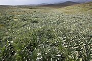
There are no trees on the island. Instead, the landscape is covered in grasslands, mosses, and special herbfields. One of the most common plants is a tall grass called Poa foliosa, which can grow up to 2 meters high in sheltered spots. The island is also home to unique plants found nowhere else, like the cushion plant Azorella macquariensis.
A Haven for Seals and Penguins
The island is a vital breeding ground for millions of seabirds and thousands of seals.
- Seals: Huge southern elephant seals come ashore to breed, and the island is home to over 80,000 of them. Several species of fur seals also live here.
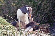
- Penguins: The island is famous for its penguins. It is the only breeding ground for the royal penguin. Large colonies of king penguins, southern rockhopper penguins, and gentoo penguins also live here.
- Other Birds: The Macquarie shag is another bird that breeds only on this island. BirdLife International has named it an Important Bird Area because it supports about 3.5 million seabirds.
A Conservation Success Story
The island's ecosystem was badly damaged by human activity, but it is now a story of successful recovery.
The Impact of New Arrivals
When sailors arrived in the 1800s, they brought new animals with them. Rats and mice arrived on ships, and cats were brought to control them. Later, rabbits were released as a source of food. These new animals, called invasive species, caused a lot of damage.
- Rats and cats hunted native birds, eggs, and chicks.
- Rabbits ate so much of the island's vegetation that they caused massive soil erosion and landslides, which destroyed penguin nesting sites.
- Two native bird species, the Macquarie Island rail and the Macquarie parakeet, became extinct because of these changes.
The Fight to Save the Island
To save the island's wildlife, a major effort began to remove the invasive species.
- Cats: A program to remove the feral cats started in 1985. By June 2000, the last cat was gone. This helped seabird populations to recover.
- Rabbits and Rodents: With the cats gone, the rabbit population exploded, causing even more damage. In 2007, the Australian and Tasmanian governments launched a $24 million plan to remove all rabbits, rats, and mice from the island.
A Flourishing Future
The pest eradication program was a huge challenge, but it worked. On April 8, 2014, Macquarie Island was officially declared pest-free. It was the largest successful island pest-eradication program in the world at the time.
Since then, the island's ecosystem has been recovering.
- The native plants are growing back, making the hillsides green again.
- Bird species that were nearly wiped out are now increasing in number.
- Birds that had disappeared from the main island, like the grey petrel and blue petrel, have returned to breed.
To keep the island safe, strict biosecurity measures are in place. All cargo and visitors are carefully checked to make sure no new pests arrive.
Life on the Island Today

Macquarie Island has no permanent residents. However, a small group of 20 to 40 people live and work at the Macquarie Island Station, a research base run by the Australian Antarctic Division. These scientists and support staff study the island's geology, weather, and wildlife.
The island is managed by the Huon Valley Council in Tasmania. It is a protected nature reserve, and access is restricted to protect its fragile environment.
Gallery
-
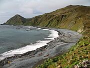
A Macquarie Island beach
-
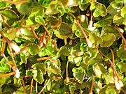
Macquarie Island flora, Epilobium pedunculare
-
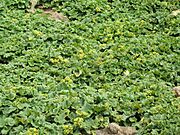
Macquarie Island flora, Stilbocarpa polaris
-
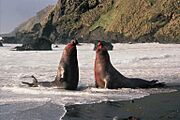
Bull elephant seals fighting
-
Gentoo penguin with chick
-
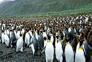
King penguins at Lusitania Bay
-
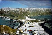
Macquarie Island Station
-
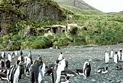
Green Gorge hut and king penguins
-
Highland herbfield dominated by Pleurophyllum hookeri


Interesting Facts About Macquarie Island
- The island was named after Colonel Lachlan Macquarie. He was the Governor of New South Wales from 1810 to 1821.
- The Russian explorer Fabian Gottlieb von Bellingshausen explored the area in 1820. He created the first map of Macquarie Island.
- Although Macquarie Island is now free of many pests, some invasive bird species, like the Domestic mallard and European starling, can still be found there.
- In the 1800s, people believed there was a "Emerald Island" south of Macquarie Island, but it was a phantom island.
- The island became a UNESCO World Heritage Site in 1992. This means it's recognized as a very important natural place globally.
Related pages
See also
 In Spanish: Isla Macquarie para niños
- Campbell Macquarie (1812 shipwreck)
- Island restoration
- List of administrative heads of Macquarie Island
- List of Antarctic and subantarctic islands
- List of islands of Tasmania
- Macquarie Fault Zone
- Macquarie Island Marine Park
- New Zealand Subantarctic Islands, which fall into the same bioregion and are its nearest neighbours.
