Phantom island facts for kids


Imagine looking at an old map and seeing an island that isn't there anymore! A phantom island is like a ghost on a map. It's an island that people once believed existed and drew on their maps, but later explorers found it was never really there.
These mysterious islands often appeared because early sailors made mistakes. They might have had trouble navigating, seen things incorrectly, heard unconfirmed stories, or sometimes, someone even made them up on purpose! Some of these islands stayed on maps for hundreds of years before people realized they were just a myth.
Phantom islands are different from lost lands. Lost lands are places that people believe once existed but then disappeared, perhaps sinking into the sea. A phantom island, however, was never truly there in the first place. Or, sometimes, it was a real piece of land, but people mistakenly thought it was an island when it was actually connected to a larger continent, like the Island of California.
Contents
Why Islands Disappear from Maps?
Mythical Islands and Legends
Some phantom islands were born from old stories and myths. For example, the Isle of Demons near Newfoundland might have come from local tales about a spooky island. Another famous one is Thule, which a Greek explorer named Pytheas mentioned in the 4th century BC. No one knows exactly where it was, and some think it was just a legend. The magical island of Hy-Brasil was often shown on maps west of Ireland, but it was always a fantasy.
Mapping Mistakes and Errors
Many phantom islands appeared because of simple mistakes on maps. Sometimes, explorers thought a piece of land was an island when it was actually connected to a continent. This happened with the Baja California Peninsula and the Banks Peninsula in New Zealand. They were drawn as islands on early maps but were later found to be part of the mainland.
Another type of mistake was when a real island was drawn in the wrong place. Pepys Island, for instance, was likely just a wrongly placed Falkland Islands. Also, Isle Phelipeaux in Lake Superior was drawn on maps for many years, even used to mark a border! But later surveys showed it didn't exist at all.
Recent Discoveries of Non-Existence
Even in more modern times, phantom islands have fooled mapmakers. Sandy Island was shown on maps of the Coral Sea since the late 1800s. It was supposed to be near New Caledonia. However, scientists on a research ship officially "undiscovered" it in 2012. It turned out to be just deep ocean!
What Else Looks Like an Island?
Sometimes, sailors mistook other things for islands. These could be:
- Waves and Reefs: Large waves breaking over shallow areas (called breakers) or hidden reefs.
- Icebergs and Fog: Huge chunks of ice or thick fog banks can look like solid land from a distance.
- Floating Rocks: Rafts of pumice (lightweight volcanic rock) can float on the ocean surface after an underwater volcano erupts.
- Mirages: Optical illusions, like a superior mirage, can make distant objects appear higher or closer than they are. This might explain New South Greenland, seen in 1823 but never again.
Islands That Disappeared for Real?
Some islands might have been real but then vanished due to natural events. Thompson Island or Bermeja could have been destroyed by volcanic explosions, earthquakes, or underwater landslides. Other times, they might have been very low-lying sand banks that eventually sank below the water. Pactolus Bank, visited by Sir Francis Drake in 1578, might be an example of a sand bank that is no longer above water.
Mapmakers' Tricks
Believe it or not, some mapmakers intentionally added fake islands! They did this for different reasons. Sometimes it was to trick people or to catch others who copied their maps without permission (a copyright trap).
Famous Phantom Islands
Here are some interesting examples of islands that once appeared on maps but were later found not to exist:
- Antillia: A legendary island in the Atlantic Ocean, often linked to the myth of Atlantis. It appeared on maps for centuries, inspiring many explorers.
- Aurora Islands: These islands were "discovered" in 1762 by a Spanish ship. People later thought they were actually Shag Rocks, which are real, but in a different location.
- Bermeja: This island was found by Spain in the early 1500s but mysteriously vanished by the 1600s. Some think it might have sunk due to underwater movements.
- Hy-Brasil: An Irish mythical island said to be covered in mist, only visible one day every seven years. It was often drawn on maps west of Ireland.
- Buss Island: Discovered in 1578 near Greenland. The explorer likely mistook optical illusions or ice formations for a new island.
- Island of California: For a long time, people thought Baja California Peninsula was an island, separated from North America by a strait. It was later found to be a peninsula!
- Crockerland: This was a hoax! Arctic explorer Robert E. Peary claimed to have seen this land in 1906 to get more money for his expeditions.
- Isle of Demons: A mythical island near Newfoundland, possibly based on local legends about a haunted place.
- Dougherty Island and Emerald Island: These were "discovered" near Antarctica in the 1800s. They were probably just large fog banks or icebergs that looked like land.
- Ernest Legouve Reef and Maria Theresa Reef: These reefs were once believed to exist in the Pacific Ocean. They even appeared in Jules Verne's adventure novels, like The Mysterious Island and In Search of the Castaways!
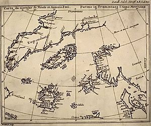
- Frisland: Shown on the Zeno map of 1558, this island was likely a mislabeled Iceland or another northern land.
- Isle Phelipeaux: A phantom island in Lake Superior that was so convincing, it was even mentioned in the 1783 Treaty of Paris as a border marker between the US and Canada!
- New South Greenland: Seen in the Weddell Sea in 1823, this was probably a superior mirage or a group of icebergs. It was never seen again.
- Pepys Island: Discovered in 1683, this was likely a mistaken sighting or misplacement of the Falkland Islands.
- Sandy Island: This island was on maps for over a century, supposedly in the Coral Sea. In 2012, scientists sailed right through its supposed location and found nothing but deep ocean.
- Thule: An ancient mythical island in the far north, mentioned by Greek and Roman writers. Its true location was always a mystery, and it might have been a legend.
See also
 In Spanish: Isla fantasma para niños
- Islands that used to exist
- Fake entries in books or maps
- Islands from stories and imagination
- Lands that disappeared
- Cities that are now hidden or gone
- A funny "island" at 0 degrees latitude and longitude
- Places from myths and legends
- Towns that appear on maps but don't exist
- Unknown lands on old maps
- Warnings about dangers on old sea charts
 | Misty Copeland |
 | Raven Wilkinson |
 | Debra Austin |
 | Aesha Ash |


