Baccalieu Island facts for kids

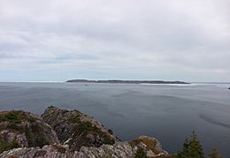
Baccalieu Island as seen from Avalon Peninsula
|
|
|
Location of Baccalieu Island in Newfoundland
|
|
| Geography | |
|---|---|
| Coordinates | 48°07′49″N 52°48′05″W / 48.13028°N 52.80139°W |
| Area | 5 km2 (1.9 sq mi) |
| Highest elevation | 137 m (449 ft) |
| Highest point | |
| Administration | |
|
Canada
|
|
| Province | Newfoundland and Labrador |
| Demographics | |
| Population | 0 |
Baccalieu Island (also called Bacalhoo Island) is a small, empty island in Newfoundland and Labrador, Canada. It's about 5 square kilometers big. It sits at the top of Conception Bay, close to a town called Red Head Cove. A narrow strip of water, called Baccalieu Tickle, separates it from the main island of Newfoundland. This area is great for fishing! The island is mostly rocky, but it does have some trees.
The name Baccalieu comes from words like "bacalhau" (Portuguese), "bacalao" (Spanish), or "baccalos" (Basque). All these words mean "codfish". Long ago, some old maps from before Christopher Columbus's voyages showed an island west of the Azores called Terra do Bacalhau. This might have been the whole island of Newfoundland! People have known Baccalieu Island by its current name since at least 1556. It was even drawn on a map by Giacomo Gastaldi as "Bacalaos".
Contents
Amazing Wildlife on Baccalieu Island
Baccalieu Island is a very important place for seabirds. It's the biggest seabird island in Newfoundland! It has the most different kinds of breeding seabirds in eastern North America.
Home to Millions of Birds
This island is home to the largest known group of Leach's storm-petrels in the world. About 40% of all these birds globally live here! That's about 70% of the ones found in the western Atlantic Ocean.
Eleven different types of birds nest on Baccalieu Island. These include:
- Atlantic puffin: About 45,000 pairs of these colorful birds nest here. This is about 12% of all Atlantic puffins in eastern North America.
- Black-legged kittiwake: Around 13,000 of these gulls make their homes on the island.
- Northern gannet: About 677 pairs of these large seabirds nest here.
- Northern fulmar
- Black guillemot
- Common murre
- Thick-billed murre
- Razorbill
- Herring gull
- Great black-backed gull
The island also has one of the biggest groups of eider ducks in Newfoundland during the winter.
Baccalieu Island Ecological Reserve
The island itself is 5 square kilometers. But the special protected area, called the Baccalieu Island Ecological Reserve, is much bigger. It covers 23 square kilometers. This includes the entire island and one kilometer of ocean all around its coast. This helps protect all the amazing birds and other wildlife that live there.
Lighthouses of Baccalieu Island
| Location | Baccalieu Island Avalon Peninsula Newfoundland and Labrador Canada |
|---|---|
| Coordinates | 48°08′59″N 52°47′54″W / 48.149849°N 52.798201°W |
| Year first constructed | 1859 (first) |
| Year first lit | 1990s (current) |
| Deactivated | 1990s (first) |
| Construction | brick tower covered by iron plates since 1893 with balcony and lantern (first) steel skeletal tower (current) |
| Tower shape | cylindrical tower with balcony and lantern (first) triangular tower (current) |
| Markings / pattern | rusty colour tower (first) white tower (current) |
| Height | 11 metres (36 ft) (first) 13.5 metres (44 ft) (current) |
| Focal height | 166 metres (545 ft) (current) |
| Characteristic | Fl W 6s. |
| Admiralty number | H0498 |
| CHS number | CCG 472 |
| NGA number | 1736 |
| ARLHS number | CAN-647 |
In the past, two lighthouses helped guide ships around Baccalieu Island. Today, both of them work automatically. The lighthouse on the northern end of the island is no longer used. Its light was turned off in the early 1990s. A newer, automated light on a metal tower took its place.
The old lighthouse was first built from brick. Later, it was covered in iron plates. The house that was attached to it was removed after 1950.
Lighthouse Keepers
For many years, families lived on the island to "keep the light" burning. The Ryan family looked after the Baccalieu lighthouse for four generations, from 1858 to 1950! Other people who worked as lighthouse keepers included Felix Noonan, Eric Blundon, John Hyde, Linus Walsh, Joseph Hatch, Pat Rice, and Raymond Hyde.
The Mystery of the Ghost Ship
In 1884, a merchant ship called the Resolven was found floating by itself. It was in the waters near Baccalieu Island and Catalina, Newfoundland and Labrador. There was no one on board! No one ever found out what happened to the crew. It remains a mystery.
 | William Lucy |
 | Charles Hayes |
 | Cleveland Robinson |


