Emerald Island (phantom) facts for kids
Imagine an island appearing on a map, only for future explorers to find nothing but empty ocean. This is the strange story of Emerald Island, a phantom island that was once believed to exist in the cold waters between Australia and Antarctica. It was said to be a small, mountainous island, but was it ever really there?
Contents
The Discovery of a Ghostly Island
The tale of Emerald Island began in December 1821. A British sealing ship, the Emerald, was sailing through the Southern Ocean, south of Macquarie Island. Its captain, William Elliot, reported seeing a new island that wasn't on any of his charts.
He described it as being small but high and mountainous. Following tradition, he named the island after his ship. The location was carefully recorded at 57°30′S 162°12′E / 57.500°S 162.200°E. For many years, mapmakers added this new "Emerald Island" to their maps based on Captain Elliot's report.
The Hunt for Emerald Island
Early Searches Find Nothing
As more ships sailed the world's oceans, people wanted to confirm if Emerald Island was real. In 1840, the United States Exploring Expedition sailed to the exact coordinates provided by Captain Elliot. When they arrived, they found nothing but the vast, empty sea. The island was nowhere to be seen.
Despite this, the idea of the island didn't disappear. Sometime before 1890, another captain visiting Port Chalmers in New Zealand claimed to have seen it, which kept the mystery alive.
The Final Search
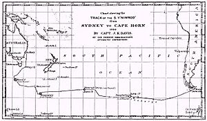
In 1909, the famous exploration ship Nimrod conducted a thorough search. The crew sailed all around the reported location, scanning the horizon for any sign of land. Once again, they found nothing. This search provided strong evidence that Emerald Island did not exist.
What Are Phantom Islands?
Emerald Island is known as a phantom island. These are islands that were once shown on maps but were later proven not to exist. So, what might Captain Elliot have seen? There are a few possibilities:
- Icebergs: Giant icebergs drifting from Antarctica can look like islands from a distance, especially on a foggy day.
- Navigational Errors: In the 1800s, calculating a ship's exact position was difficult. Captain Elliot might have seen a real island but recorded its location incorrectly.
- Optical Illusions: Strange light conditions over the ocean can create mirages, making things appear where they are not.
A Lasting Name on the Map
Even though the island was never found, its story didn't completely vanish. Amazingly, Emerald Island still appeared on some maps for many decades. It was even included in an atlas published by American Express as late as 1987!
Today, the name lives on in a different way. The deep, flat part of the ocean floor (abyssal plain) where the island was supposed to be is officially named the Emerald Basin. So, while you can't visit the island, its name is still marked on modern maps of the seabed.
See also
- Royal Company's Islands
- Nimrod Islands
- Dougherty Island
 | William L. Dawson |
 | W. E. B. Du Bois |
 | Harry Belafonte |


