Dougherty Island facts for kids
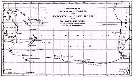
Dougherty Island was once believed to be a mysterious piece of land in the very southern part of the Pacific Ocean. Imagine a place that explorers thought they saw, but it turned out not to be there at all! This kind of place is called a phantom island. Dougherty Island was thought to be located roughly halfway between Cape Horn (the southern tip of South America) and New Zealand.
Discovering a Phantom Island
The island was named after Captain Dougherty. He was the captain of an English whaling ship called the James Stewart. In 1841, Captain Dougherty reported that he had discovered this island. He gave its location as about 59°20′S 120°20′W / 59.333°S 120.333°W. He described it as being about 5 to 6 miles (8 to 10 kilometers) long. He also said it had a tall cliff on its northeast side and was covered in snow.
Other captains later reported seeing the island too. In 1860, Captain Keates of the ship Louise gave similar coordinates of 59°20′S 120°18′W / 59.333°S 120.300°W. Then, in 1886, Captain Stannard of the Cingalese also reported seeing it. He gave the location as 59°21′S 119°7′W / 59.350°S 119.117°W. These reports made people believe that Dougherty Island truly existed.
The Mystery Unravels
Despite these sightings, later and more detailed explorations of the area proved that Dougherty Island was not real. During the late 1800s and early 1900s, many ships sailed through this part of the ocean. They searched carefully but found no island.
One important explorer was Captain Davis. He was on the ship Nimrod. Captain Davis suggested a good reason why the earlier captains might have been mistaken. He thought that Captain Dougherty, Captain Keates, and Captain Stannard had probably seen large fog banks or huge icebergs. None of them had actually landed on the island, so it was easy to be fooled by the tricky conditions of the southern ocean. Captain Davis famously said, "I am inclined to think Dougherty Island has melted." This meant he believed what they saw was likely ice that later disappeared.
Even after it was known that the island didn't exist, it still appeared on some maps. It was shown on maps as late as 1934! This shows how long it can take for old information to be corrected, especially about remote parts of the world.
Explore More Phantom Islands
- Royal Company's Islands
- Emerald Island (phantom)
- Nimrod Islands
- Sandy Island, New Caledonia, another phantom island that stayed on many maps until recently
 | Stephanie Wilson |
 | Charles Bolden |
 | Ronald McNair |
 | Frederick D. Gregory |


