Berriedale, Tasmania facts for kids
Quick facts for kids BerriedaleHobart, Tasmania |
|||||||||||||||
|---|---|---|---|---|---|---|---|---|---|---|---|---|---|---|---|

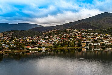
View of Berriedale from MONA
|
|||||||||||||||
| Population | 2,905 (2021 census) | ||||||||||||||
| Postcode(s) | 7011 | ||||||||||||||
| LGA(s) | City of Glenorchy | ||||||||||||||
|
|||||||||||||||
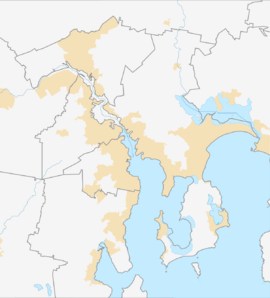
Berriedale is a suburb located in the northern part of Hobart. Hobart is the capital city of Tasmania, Australia. Berriedale is part of the City of Glenorchy. It sits between the suburbs of Chigwell and Rosetta. The suburb is about 15 kilometers from Hobart’s city centre.
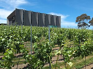
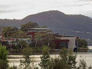
Berriedale is famous for being home to the Museum of Old and New Art (MONA). This museum, along with the nearby Moorilla Estate winery, is a major cultural spot. It attracts many tourists to Tasmania.
In the 1800s, Berriedale was a busy place for travellers. The Berriedale Inn opened in 1834. It was an important meeting spot for the community. People believe the inn gave the suburb its name.
Most homes in Berriedale were built in the mid-1900s. They show how Tasmania grew after World War II. These homes often have one story and are made of wood or brick. They usually have big yards and gardens. MONA has made Berriedale much more well-known.
Contents
Where is Berriedale?
Berriedale is right on the Derwent River. This gives it beautiful water views. The Brooker Highway goes through the suburb. This highway is a main road in Hobart. It divides Berriedale into "East Berriedale" and "West Berriedale." The eastern part is along the river. The western side goes towards the countryside.
Berriedale's Past
Berriedale has a long history as a small town. It is about 15 kilometers north of Hobart. The name of the suburb might come from the Berriedale Inn. This inn opened in 1834 and was very important. William Wilson was its first owner. The inn was at a main crossroads. This area was once a path to places like Bismark and Sorell Creek.
The Moorilla Estate was started in 1947. An Italian immigrant named Claudio Alcorso created it. He turned the land into a winery. He planted vineyards and built an Italian-style farmhouse in 1954. The estate became a place for arts and culture. Alcorso supported local artists and musicians. Famous architect Roy Grounds designed buildings there in the 1950s.
In 1995, David Walsh bought the estate. He made it much bigger and created MONA. MONA opened in 2011 and is now known worldwide. The museum has amazing underground galleries. It also has beautiful gardens and great views of the Derwent River. You can also see kunanyi / Mount Wellington from there. MONA helps the area a lot. It hosts big festivals like Dark Mofo every year.
Berriedale was also known for sports. It was the finish line for a long-distance cycling race. This race, from Campbell Town, was popular in the 1920s.
Who Lives in Berriedale?
| Historical population | ||
|---|---|---|
| Year | Pop. | ±% |
| 2001 | 2,100 | — |
| 2006 | 2,250 | +7.1% |
| 2011 | 2,350 | +4.4% |
| 2016 | 2,692 | +14.6% |
| 2021 | 2,905 | +7.9% |
| Source: Australian Bureau of Statistics data. | ||
In 2021, about 2,905 people lived in Berriedale. By 2023, this number was around 3,000. This means about 1,228 people live in each square kilometer.
The average weekly income for families in Berriedale is a bit lower than the national average. About 5.2% of residents are Indigenous Australians. Most people (80.0%) were born in Australia. Also, 83.8% of people speak only English at home.
When it comes to religion, 43.2% said they had no religion. Then, 18.2% were Anglican, and 16.8% were Catholic.
Getting Around and Services
Roads and Travel
The Brooker Highway runs through Berriedale. This road connects northern Hobart to the city centre. It also links to places like Bridgewater and Brighton. Metro Tasmania provides public buses. These buses run regularly along the highway. They go to nearby suburbs like Glenorchy and Claremont. Berriedale is close to other major roads. These include the Lyell Highway and Midland Highway. This makes it easy for people to travel for work. Passenger trains used to serve Berriedale. But train services in Hobart stopped in 1974.
Learning and Schools
There are no schools right in Berriedale. But several schools are very close by. Claremont College is for students in years 11 and 12. Montrose Bay High School is in Rosetta. There are also primary schools in Claremont and Rosetta. You can easily get to these schools by bus or car.
Everyday Services
TasWater manages water supply, waste, and sewerage. TasNetworks provides electricity. Tasmania gets its power from clean, renewable sources. Most homes have fast internet through the National Broadband Network (NBN).
Fun and Culture
Berriedale is home to MONA. This is one of Tasmania's most important cultural places. MONA has changing art shows and live events. It also hosts the Dark Mofo festival. This festival brings visitors from all over Australia.
The suburb also has nice green spaces. These include Alroy Court Reserve and Chandos Drive Reserve. The International Peace Forest is along the Derwent River.
The Berriedale Caravan Park is next to MONA. It offers affordable places for tourists to stay. If you like food, The Source Restaurant at MONA is great. It uses local Tasmanian food. It also has amazing views of the Derwent River.
As mentioned, Berriedale was the finish line for a famous bike race. This was the Campbell Town to Berriedale Race in the 1920s.
What's Next for Berriedale?
MONA's popularity is leading to new projects. These include improving roads and public spaces. Other nearby projects will also help Berriedale residents. They will bring better services and transport links.
 | Selma Burke |
 | Pauline Powell Burns |
 | Frederick J. Brown |
 | Robert Blackburn |


