Rosetta, Tasmania facts for kids
Quick facts for kids RosettaHobart, Tasmania |
|||||||||||||||
|---|---|---|---|---|---|---|---|---|---|---|---|---|---|---|---|

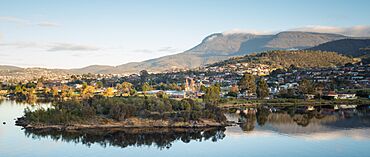
View of Rosetta and kunanyi from MONA, 2018
|
|||||||||||||||
| Population | 2,833 (2021 census) | ||||||||||||||
| Postcode(s) | 7010 | ||||||||||||||
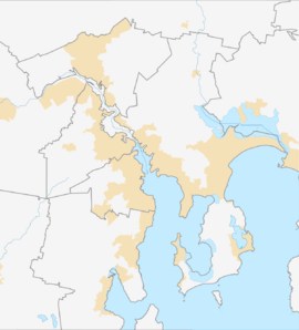
| Location | 3 km (2 mi) NW of Glenorchy | ||||||||||||||
| LGA(s) | City of Glenorchy | ||||||||||||||
| Region | Hobart | ||||||||||||||
| State electorate(s) | Clark | ||||||||||||||
| Federal Division(s) | Clark | ||||||||||||||
|
|||||||||||||||
Rosetta is a friendly neighbourhood located in Tasmania, Australia. It's about 3 kilometres northwest of Glenorchy. In 2021, about 2,833 people lived there. Rosetta is part of the wider Hobart LGA Region and is close to the Derwent River. It's also home to both a primary school and a high school.
Contents
History of Rosetta
Long ago, the hills and shores around Rosetta were home to farmers. These farmers grew many different fruits like apples, plums, peaches, and apricots. Rosetta was once part of another area called Montrose. The name "Rosetta" became official in 1961. For many years, people could travel to Rosetta by passenger train, but these services stopped in 1974.
Marys Hope Farm
A long time ago, in the 1840s, a man named Frederick Bück was given land here. This land later became known as Marys Hope Farm. It's believed that "Mary" was named after Frederick's wife, Marie Henriette Christiana Buck. Sadly, Mary passed away at a young age. The original farmhouse, built before 1850, was destroyed in the big bushfires of 1967. Today, a main road in the area is still called Marys Hope Road.
Homes Built by Hobart Savings Bank
Starting in 1948, the Hobart Savings Bank began building homes in the area. They built 38 brick houses for young couples and people who had served in the military. These homes were well-designed and became very popular. By 1951, the bank started a new housing project on Marys Hope Road in Rosetta. Here, they built 26 more homes, carefully planned to get lots of sunlight and offer nice views.
Environment and Monitoring
Near Rosetta, there is a factory called the Risdon Zinc Works in Lutana. This factory has been operating since 1917. Like many older industrial sites, it has produced some substances that can affect the air, land, and water nearby. Environmental groups, like the Australian Conservation Foundation, keep an eye on these things. They use information from the National Pollutant Inventory to track environmental quality in different areas, including parts of Hobart.
Geography
The River Derwent forms the boundary on the north-eastern side of Rosetta.
Roads in Rosetta
A major road, National Route 1, also known as the Brooker Highway, runs through Rosetta.
Shops and Services
Rosetta has a few local businesses and services:
- Rosetta Plumbing
- Marys Hope Road, hot food and convenience store
- Undine Colonial, a bed and breakfast
 | Jessica Watkins |
 | Robert Henry Lawrence Jr. |
 | Mae Jemison |
 | Sian Proctor |
 | Guion Bluford |


