
Rideau Canal facts for kids
Quick facts for kids Rideau Canal |
|
|---|---|
| Native names English: Rideau Canal French: Canal Rideau |
|

Locks in summer
|
|
| Area | Ontario |
| Length | 202 km (126 mi) |
| Built | 1832 |
| Architect | John By |
| Governing body | Parks Canada |
| Type | Cultural |
| Criteria | i, iv |
| Designated | 2007 (31st session) |
| Reference no. | 1221 |
| State Party | Canada |
| Region | North America |
| Designated | 1925 |
| Canadian Heritage River | 2000 |
| Rideau Canal | |
|---|---|
| Specifications | |
| Length | 202 km (126 miles) |
| Maximum boat length | 90 ft 0 in (27.43 m) |
| Maximum boat beam | 28 ft 0 in (8.53 m) |
| Maximum boat draft | 1.5 m (5 ft) |
| Locks | 47 |
| Status | Open |
| History | |
| Construction began | 1826 |
| Date completed | 1832 |
| Geography | |
| Start point | Ottawa River |
| End point | Lake Ontario |
The Rideau Canal, also known as the Rideau Waterway, is a historic canal system in Canada. It connects Ottawa, the capital city of Canada, to Lake Ontario at Kingston. The canal is 202 kilometers (125 miles) long. Its name, Rideau, means "curtain" in French. This name comes from the curtain-like look of the Rideau River's twin waterfalls where they meet the Ottawa River.
The canal system uses parts of two rivers, the Rideau and the Cataraqui, along with several lakes. Parks Canada manages the Rideau Canal. It was built in 1832 as a way to protect Canada in case of war with the United States. Today, it is mainly used for fun boating. Most of its original structures are still there. The locks open for boats in mid-May and close in mid-October. It is the oldest canal system in North America that has been used continuously. In 2007, it became a UNESCO World Heritage Site.
Contents
History of the Rideau Canal

Why the Canal Was Built
After the War of 1812 (a conflict between the United States and Great Britain), the British worried about future attacks. They heard that the United States might try to invade Upper Canada (now part of Ontario). This invasion could happen by following the St. Lawrence River. If this happened, it would cut off the link between Montreal and the important naval base at Kingston.
To prevent such an attack, the British built new defenses. These included Citadel Hill, La Citadelle, and Fort Henry. They also planned a new, safer water route. This route would go from Montreal along the St. Lawrence, then north along the Ottawa River to Bytown (which is now Ottawa). From Bytown, it would go southwest by canal to Kingston and into Lake Ontario. The Rideau Canal was the last part of this important route.
Building the Canal

Lieutenant-Colonel John By of the Royal Engineers was in charge of building the canal. Many private companies helped with the construction. Thousands of Irish and French-Canadian workers did most of the hard work. Colonel John By decided to build a "slackwater" canal system. This meant using existing rivers and lakes and connecting them with canals. This method was smarter because it needed fewer workers and cost less money.
Work on the canal began in the fall of 1826. It was finished by the spring of 1832. The first steamboat to travel the whole canal was named Rideau. It left Kingston on May 22, 1832, with Colonel By and his family on board. It arrived in Bytown on May 29, 1832.
The canal cost about £822,804 to build. This was more than expected. Because of the extra costs, John By was called back to London and retired. He did not receive much praise for his huge achievement.

Early Commercial Use
After the canal was finished, there were no more wars between Canada and the United States. Even though the Rideau Canal was not used for defense, it was very important for Canada's early growth. It helped with shipping, trade, and bringing many immigrants to Upper Canada.
The Rideau Canal was easier to travel than the St. Lawrence River. This was because the St. Lawrence had many dangerous rapids between Montreal and Kingston. So, the Rideau Canal became a busy route for trade between Montreal and the Great Lakes. It was also used by tens of thousands of immigrants from the British Isles. They traveled west into Upper Canada during this time.
The canal was a main route for shipping heavy goods like timber, minerals, and grain to Montreal. Hundreds of barges used the Rideau each year. For example, in 1841, 19 steamboats and many barges used the canal.
Why Commercial Use Ended
By 1849, new locks were built on the St. Lawrence River. These locks made the river safer for ships. Commercial shippers quickly switched to this more direct route. The Rideau Canal's commercial use mostly ended after the Prescott and Bytown Railway opened in December 1854. Trains offered much faster service than canal boats.
Later, in the 1950s, the St. Lawrence River was developed into the Saint Lawrence Seaway. This allowed large ocean ships to reach the Great Lakes.
Modern Use of the Canal
After railways came to Ottawa, the canal was mostly used for fun boating. When outboard motors became popular, more small pleasure boats used waterways like the Rideau. Today, the Rideau Canal is part of the Great Loop. This is a big water route connecting a large area of the eastern United States and Canada.


Canal Recognition
The Rideau Canal has received many special honors:
- It was named a National Historic Site of Canada in 1925.
- It was featured on postage stamps by Canada Post in 1998, 2014, and 2016.
- In 2000, the Rideau Waterway became a Canadian Heritage River. This was because of its amazing history and recreational value.
- In 2007, it was named a UNESCO World Heritage Site. This means it is a unique example of human creativity. The Rideau Canal is the best-preserved example of a "slack water" canal in North America. It still works today with most of its original parts. It is also important because it was built for military reasons during a key time in history.
Plaques have been put up at different places along the canal. These plaques honor Lieutenant Colonel John By and the canal's history.
The Rideau Waterway
The Rideau Canal is 202 kilometers (125 miles) long. It includes parts of the Rideau and Cataraqui rivers. It also connects several lakes, like the Lower, Upper, and Big Rideau lakes. About 19 kilometers (12 miles) of the route were built by people.
Many towns and cities are along the waterway. These include Ottawa, Manotick, Kars, Burritts Rapids, Merrickville, Smiths Falls, Rideau Ferry, Portland, Westport, Newboro, Seeleys Bay and Kingston. Other towns like Kemptville and Perth are connected by navigable waterways.
Since World War I, only pleasure boats use the Rideau Canal. It takes 3 to 5 days to travel one way through the canal by motorboat. You can take boat tours in Ottawa, Kingston, Merrickville, and Chaffeys Lock. A cruise ship called Kawartha Voyageur also operates here.
Most of the locks are still operated by hand. There are 45 locks at 23 stations along the canal. There are also two more locks for the Tay Canal (which leads to Perth). You can also see four blockhouses and some of the original homes for lockmasters. The old Commissariat Building and the foundation of the Royal Engineers' barracks are still at the Ottawa Lock Station. The waterway is home to many kinds of birds, reptiles, amphibians, mammals, and fish.
In 1973–74, a new lock (29a) was built in Smiths Falls. It bypassed the original three locks (28–30), which were left in place.
How the Locks Work
The Rideau Canal uses a lock system that still works perfectly. The gates that let boats in and out of the locks last about 12–15 years. When the canal was built, carpenters and blacksmiths made the gates right at the lock sites. Today, they are made in Smiths Falls, Ontario. It can take up to two months to build a set of gates.
The gates on the Rideau Canal are made of Douglas fir wood. They are shaped like a "mitre" (a V-shape) to create a tight seal when water pushes against them. On average, one lock lift on the Rideau Canal uses 1.3 million liters (about 343,000 gallons) of water.
Boat Sizes for the Canal
Normally, the canal can handle boats up to 27.4 meters (90 feet) long. They can be up to 7.9 meters (26 feet) wide and 6.7 meters (22 feet) high. The boat's bottom (draft) can be up to 1.5 meters (5 feet) deep. If a boat is deeper than 1.2 meters (4 feet), you should contact the Rideau Canal Office of Parks Canada before your trip. In special cases, a boat up to 33.5 meters (110 feet) long and 9.1 meters (30 feet) wide can be handled.
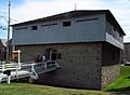
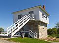
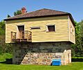
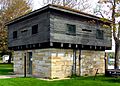
Blockhouses Along the Canal
Four blockhouses were built between 1826 and 1832. These small forts were meant to protect the canal when it was controlled by the British Forces.
- Merrickville Blockhouse: Used for a short time during the 1837 Rebellion. It later became a home for the lockmaster. It was restored as a museum in the 1960s.
- Kingston Mills Blockhouse: Used in 1837–1838. It was then made bigger to be a home. It was restored to its 1830 look in the 1960s.
- Newboro Blockhouse: Built by the British Ordnance Department. It was also used for military purposes in the 1830s. Later, it became a home for the lockmaster. It was restored in the 1960s.
- Rideau Narrows Blockhouse: Built by William H. Tett. It was also changed in the 1800s to be a lockmaster's home. It was restored to its original look from 1967 to 1970.
A fifth blockhouse at Burritts Rapids was started in 1832 but never finished. It was later rebuilt and then taken down in 1969.
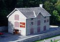
The Commissariat Building
The Commissariat Building is the oldest stone building still standing in Ottawa. It was built in 1827. It was used as a storage building for the British Military in Upper Canada. The building has three floors, a strong vault, and two sets of stairs. It also has a system to lift goods to the upper floors. After being used for workshops and apartments, the Commissariat Building has been home to the Bytown Museum since 1917.
Parliament Hill was originally planned to be the site of a fortress called Citadel Hill. This fortress would have been where the canal met the Ottawa River.
Rideau Canal Skateway

In winter, a part of the Rideau Canal in central Ottawa becomes the world's largest and second longest skating rink. This cleared section is 7.8 kilometers (4.8 miles) long. It has the same surface area as 90 Olympic ice hockey rinks. It stretches from the Hartwell locks at Carleton University to the locks near the Parliament Buildings and the Château Laurier. This includes Dow's Lake.
The Skateway is a popular place for tourists and for fun activities. It is also a main part of the Winterlude festival in Ottawa. You can buy Beaver Tails (a fried pastry) and other snacks and drinks from kiosks along the skateway.
In January 2008, Winnipeg, Manitoba, had the world's longest skating rink. It was 8.54 kilometers (5.3 miles) long, but only 2 to 3 meters (6.5 to 10 feet) wide. In response, the Rideau Canal was then called "the world's largest skating rink." The Rideau Canal Skateway was added to the Guinness Book of World Records in 2005. It was recognized for being the largest naturally frozen ice rink in the world.
The Skateway is open 24 hours a day. How long it stays open depends on the weather. Usually, the Rideau Canal Skateway opens in January and closes in March. Because of global warming, the average winter temperature in the area has been rising. This has made the skating season start later and become shorter. The longest season was 90 days in 1971–1972. The shortest was only 34 days in 2015–2016, with only 18 skating days.
| Season | Opened | Closed | Days of skating |
|---|---|---|---|
| 51st | January 28, 2021 | February 25, 2021 | 26 |
| 50th | January 18, 2020 | February 26, 2020 | 31 |
| 49th | December 30, 2018 | March 10, 2019 | 59 |
| 48th | January 5, 2018 | February 21, 2018 | 35 |
| 47th | January 14, 2017 | February 18, 2017 | 25 |
| 46th | January 23, 2016 | February 25, 2016 | 18 |
| 45th | January 10, 2015 | March 9, 2015 | 59 |
| 44th | December 31, 2013 | March 11, 2014 | 58 |
| 43rd | January 18, 2013 | February 28, 2013 | 38 |
| 42nd | January 15, 2012 | February 22, 2012 | 26 |
| 41st | January 8, 2011 | March 6, 2011 | 53 |
| 40th | January 14, 2010 | February 26, 2010 | 36 |
| 39th | January 1, 2009 | March 5, 2009 | 58 |
| 38th | January 25, 2008 | March 5, 2008 | 34 |
| 37th | January 26, 2007 | March 12, 2007 | 45 |
| 36th | January 7, 2006 | March 10, 2006 | 39 |
| 35th | December 28, 2004 | March 16, 2005 | 66 |
| 34th | January 14, 2004 | February 28, 2004 | 46 |
| 33rd | January 3, 2003 | March 16, 2003 | 66 |
| 32nd | February 2, 2002 | March 8, 2002 | 26 |
| 31st | December 29, 2000 | March 9, 2001 | 69 |
| 30th | December 31, 1999 | February 23, 2000 | |
| 29th | January 2, 1999 | March 16, 1999 | |
| 28th | December 21, 1997 | March 2, 1998 | 46 |
| 27th | January 12, 1997 | March 22, 1997 | 57 |
| 26th | January 1, 1996 | February 23, 1996 | 47 |
| 25th | January 1, 1995 | March 9, 1995 | 50 |
| 24th | December 30, 1993 | March 11, 1994 | |
| 23rd | December 29, 1992 | March 1, 1993 | |
| 22nd | December 28, 1991 | March 6, 1992 | |
| 21st | January 4, 1991 | March 2, 1991 | |
| 20th | December 24, 1989 | February 22, 1990 | |
| 19th | December 23, 1988 | March 14, 1989 | |
| 18th | January 4, 1988 | March 7, 1988 | |
| 17th | January 7, 1987 | March 2, 1987 | |
| 16th | December 27, 1985 | February 23, 1986 | |
| 15th | January 4, 1985 | February 22, 1985 | |
| 14th | December 25, 1983 | February 17, 1984 | |
| 13th | January 2, 1983 | February 14, 1983 | |
| 12th | December 27, 1981 | February 21, 1982 | |
| 11th | December 18, 1980 | February 17, 1981 | |
| 10th | January 1, 1980 | February 22, 1980 | 43 |
| 9th | January 5, 1979 | February 23, 1979 | |
| 8th | December 29, 1977 | March 9, 1978 | |
| 7th | December 14, 1976 | February 27, 1977 | 45 |
| 6th | December 20, 1975 | February 26, 1976 | |
| 5th | December 31, 1974 | February 28, 1975 | |
| 4th | January 1, 1974 | February 28, 1974 | |
| 3rd | December 25, 1972 | 1973 | 45 |
| 2nd | December 26, 1971 | March 25, 1972 | |
| 1st | January 18, 1971 | February 26, 1971 |
For many years, some Ottawa residents skated on the canal. But making it an official skateway and tourist spot is newer. In 1970, the city government even thought about paving over the canal to make a highway! However, the federal government owned the canal, so the city could not do this.
When Doug Fullerton became head of the National Capital Commission (NCC), he suggested a fun area around the canal. This included the winter skateway. The plan started on January 18, 1971, even though the city council was against it. NCC workers cleared a small part of the ice with brooms and shovels. That first weekend, 50,000 people skated on the canal! Today, the skating area is much bigger. This is because of modern equipment and 24/7 maintenance crews. The skateway now gets about one million visits each year.

Getting the Skateway Ready
Work for the Skateway begins as early as mid-October. After the boating season ends, water is drained from the Ottawa locks by Parks Canada. Then, things like shelters, chalets, and ramps for vehicles are put on the ice. Next, "beams are placed at the locks, and the water is raised to skating level." After this, stairs to get onto the ice and hookups for water and electricity are added. The ice that forms as the canal freezes becomes the Rideau Canal Skateway.
When the ice is thick enough, snow is removed. Then, water is added to the surface to make the ice even thicker and smoother. Ice samples are tested for quality and thickness. When it is safe, the Rideau Canal Skateway opens for the season.
The NCC (National Capital Commission) takes care of the Rideau Canal Skateway. Crews work 24 hours a day, seven days a week, to maintain the ice. Snow and ice shavings are cleared off every day. The ice surface is flooded every night with a special machine (if the weather allows). This fills in any cracks. There are about 20 holes along the Skateway that flood the ice to make it smoother.
Two types of ice can form on the Rideau Canal Skateway: "white ice" and "clear ice". White ice looks milky and has air bubbles. It forms when snow and water mix and then freeze. It can also be made by adding water to the ice surface to make it thicker. Clear ice looks colorless. It forms when ice crystals build up under the frozen surface in cold weather. If snow builds up on the ice, it can make skating harder. Snow pushes down on the ice and slows down the formation of new ice crystals.
Ice conditions are updated twice a day by the NCC. They are rated as very good, good, fair, or poor. "Very good" conditions mean there are few cracks, the ice is hard and strong, and the surface is clean, smooth, and great for gliding.
Images for kids
-
At Merrickville
-
At Kingston Mills
-
At Newboro
-
At Rideau Narrows
-
Commissariat Building
-
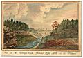
View on the Cataraqui Creek, Brewer's Upper Mills in the background, 1830 by Thomas Burrowes


See also
 In Spanish: Canal Rideau para niños
