
Cataraqui River facts for kids
The Cataraqui River is a cool river in Ontario, Canada. It forms the lower part of the famous Rideau Canal and flows into Lake Ontario at Kingston, Ontario. The name "Cataraqui" comes from an old name for Kingston, but its exact meaning is a bit of a mystery! Long ago, it was even called the Frontenac River.
Contents
The River Before the Canal
Before the Rideau Canal was built (between 1826 and 1832), the Cataraqui River was very different. It started from lakes like Dog Lake and Loughborough Lake. It was more like a winding creek with many fast-flowing sections called rapids. People often had to carry their boats around these rapids. A map from 1795 even mentioned "a great number of rapids and Carrying Places" along the creek.
Building the Rideau Canal
The building of the Rideau Canal completely changed the Cataraqui River. The main engineer for the project, Lt. Colonel John By, used a special method called "slackwater construction." This meant building dams to flood the rapids and make the river deeper and calmer.
In the area from Upper Brewers to Kingston Mills, workers cut down many trees to create a straighter path for the canal. You can still see how much work was done in old paintings from that time. Then, in late 1831 and early 1832, the area was flooded after dams were finished at Kingston Mills, Lower Brewers, and Upper Brewers. This turned the winding creek into a wider, deeper waterway suitable for boats.
How the River's Path Changed
Today, the Cataraqui River's watershed (the area of land that drains into it) includes lakes like Sand, Opinicon, Clear, and Newboro. But before the canal, water from these lakes actually flowed into the White Fish River, which then went into the Gananoque River. Only during big spring floods would some of that water reach the Cataraqui River.
This started to change in the early 1800s. A man named Lemuel Haskins built a mill dam at White Fish Falls, near what is now the village of Morton. This dam slowed down the White Fish River's flow to the Gananoque River. It caused the water to back up over a flat area called the Cranberry Flood Plain, sending more water south towards the Cataraqui River.
To keep his mill water from flowing away down the Cataraqui Creek, Haskins built a second dam. This dam was at a place called the Round Tail, just north of Upper Brewers. It blocked the creek's channel. These two dams made it possible for boats to travel on the Cataraqui Flood Plain for the first time.
When the Rideau Canal was built, Haskins' dam at Morton was made even bigger. A new dam was also built at Upper Brewers. These two dams, which are now managed by Parks Canada, created Whitefish Lake, Little Cranberry Lake, and much larger Cranberry and Dog lakes. Now, most of the water that used to flow into the White Fish River watershed flows down the Cataraqui River instead.
Managing the River Today
The Cataraqui Region Conservation Authority is in charge of managing the water and protecting the environment within the Cataraqui River's watershed. They work to keep the river healthy for everyone.
Images for kids
-
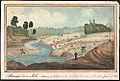
The lock at Lower Brewers nearing completion in 1831 by Thomas Burrowes
-
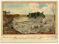
Brewer's Lower Mill - view down the Cataraqui Creek and clearing made for the Rideau Canal, 1829 by Thomas Burrowes
-
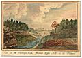
View on the Cataraqui Creek, Brewer's Upper Mills in the background, 1830 by Thomas Burrowes


