
History of Ottawa facts for kids
The history of Ottawa, Canada's capital city, is a fascinating story shaped by many important events. These include the building of the Rideau Canal, the busy lumber industry, and the special decision to make Ottawa the capital of Canada. The city has also been influenced by ideas and people from America and Europe. By 1914, Ottawa had grown to over 100,000 people. Today, it is the capital of a major country, and its larger metropolitan area is home to more than a million people.
The name "Ottawa" comes from the Algonquin language word adawe, which means "to trade". This word refers to the Algonquin people who used the Ottawa River for trading, hunting, fishing, camping, and other traditional activities. Early maps of the area began to name the main river after these First Nations people.
For hundreds of years, Algonquin people traveled by portage (carrying canoes and goods over land) through the waterways of both the Ottawa River and the Rideau River. French explorer Étienne Brûlé was likely the first European to see the powerful Chaudière Falls in 1610. He also had to portage around them to travel further inland. No permanent European settlement was built in the area until 1800. That's when Philemon Wright started his village near the falls, on the north side of the Ottawa River.
The building of the Rideau Canal was a big project. It was started because people were worried about defense after the War of 1812. Plans for the canal were made by Lieutenant Colonel John By and Governor General Dalhousie. Construction began soon after September 26, 1826, which is when Ottawa's first version, Bytown, was founded. Lt. Colonel John By was a British Army officer who was put in charge of building the Rideau Canal in 1826.
The founding of Bytown was marked by a special ceremony. Colonel By was given permission to divide the town into building lots. Bytown grew into a center for the timber trade, and later for sawed lumber. This growth was so successful that in 1854, Bytown became a city and was given its current name, Ottawa.
Soon after, Queen Victoria chose Ottawa to be the capital of Canada. The impressive parliament buildings on Parliament Hill were completed not long after. At this time, Ottawa also connected to other places by rail. This helped ship goods, especially lumber, to markets in the United States. In the early 1900s, the lumber industry became less important as there was less wood available and less demand for it.
Ottawa continued to grow in the 20th century. By the 1960s, a plan called the Greber Plan changed the city's look, removing much of the old industrial areas. By the 1980s, Ottawa became known as Silicon Valley North. This was because many large high tech companies started there, bringing wealth and causing the population to grow a lot. In 2001, the city combined all the surrounding areas into one large city. Today, plans continue for growth and improving transportation.
Contents
Early Peoples and European Explorers
About 10,000 years ago, the Champlain Sea dried up, making the Ottawa Valley a good place to live. The Algonquin people (who are part of the Anishinaabe group) called the Ottawa River the Kichi Sibi or Kichissippi, meaning "Great River". They used the Ottawa River as a trade route for a long time. The name "Ottawa" is linked to the Ottawa people, a First Nation who hunted, camped, traded, and traveled in the area. They also lived further west near Georgian Bay and Lake Huron.

When Étienne Brûlé became the first European to travel up the Ottawa River in 1610, followed by Samuel de Champlain in 1613, Algonquin guides helped them. Records from 1613 show that the Algonquins controlled the Ottawa Valley and the areas to the west and north. Champlain made a map in 1632 showing parts of the Ottawa River route he took. He marked important sites, rapids, and Indigenous camps. Numbers 77 and 91 on his map show the locations of modern-day Ottawa and the Rideau River.
Champlain wrote about both the Rideau Falls (named later by canoeists) and the Chaudière Falls (named by Champlain). The Chaudière Falls were later used by the lumber industry. For about two centuries, there were no signs of permanent settlements in present-day Ottawa. However, the Ottawa and Rideau rivers were often used for travel. The Chaudière Falls were, and still are, impossible to pass by boat. So, people used portage paths around them when traveling from the mouth of the Ottawa River to the Great Lakes. Many missionaries, coureur des bois (fur traders), and voyageurs (travelers) passed through Ottawa. These included Jean de Brébeuf in 1634, Médard des Groseilliers in 1654, Pierre-Esprit Radisson, and later explorers like Pierre Gaultier de Varennes, sieur de La Vérendrye and Alexander Mackenzie.
The Algonquin were not the only people in what is now Ontario. During the 17th century, the Algonquins and Hurons fought a difficult war against the Iroquois. Champlain helped the Hurons in their battles against the Iroquois Confederacy. Because of this, the Iroquois became enemies of the French and fought in many conflicts, known as the Beaver Wars, until a peace treaty was signed in 1701.
Before European Settlement
The Seven Years' War between Great Britain and France ended in 1763 with the Treaty of Paris. This treaty confirmed that Great Britain had won control of Canada. After defeating the French and their Native allies, Great Britain controlled all of Canada. As a result, English-speaking settlers from Great Britain began to move to areas west of Montreal.

The population in Eastern Ontario also grew after the American Revolution in 1776. Many United Empire Loyalists (people loyal to Britain) moved to Canada. Britain helped them by giving them land and other things to restart their lives. The Constitutional Act of 1791 created the provinces of Upper Canada (present-day southern Ontario) and Lower Canada (present-day southern Quebec). This meant that two different cultural regions were forming: English-speaking Protestant settlers in Upper Canada and French-speaking Catholics in Lower Canada.
Upper Canada had its own government. Its capital was moved to York (now Toronto) by 1796. This choice was made partly because of the threat of attacks from the Americans. This threat also led to the building of the Rideau Canal. By the time British settlers arrived near Ottawa, there were two main local areas: Nepean Township to the west of the Rideau River and Gloucester Township to the east. These areas were formed in 1793.
The War of 1812 showed Upper Canada that it could defend itself against American attacks, but the threat remained. This directly led to the creation of military settlements like Perth, Ontario. By the time Bytown was founded, Kingston, Ontario, had 2,849 people, York had 1,677, Perth had 1,500, and Brockville had nearly 1,000. In Lower Canada, Montreal and Quebec City were much larger, each with 22,000 people.
Settlement and Growth
Early Settlers

The first major European settlement near Ottawa was started by Philemon Wright. He was from Woburn, Massachusetts, in New England. On March 7, 1800, he arrived with his family and four other families, plus twenty-five workers. They began a farming community called Wright's Town (now Gatineau, Quebec) on the north bank of the Ottawa River, near the Chaudière Falls. After six years, farming wasn't enough to support the community. Wright then started cutting down trees to sell. He realized he could float timber down the Ottawa River to Montreal and Quebec City, and then send it to Europe. His first raft of squared timber and sawed lumber reached Quebec City in 1806. This location helped with much of the future settlement on the south side of the river. By this time, land on the Ottawa side of the river had already been measured and given out.
In 1818, a settlement was formed at Richmond Landing, in what is now LeBreton Flats. At the same time, Richmond Road, Ottawa's first main road, was being built. Families of English soldiers who came to create the Richmond settlement stayed for months at this spot. It had a store since 1809, built by Jehiel Collins, who is considered the first settler of what would become Bytown. Over the years, other settlers like Braddish Billings, Abraham Dow, Ira Honeywell, and John LeBreton arrived. Much of Ottawa's early land was owned by Nicholas Sparks. Another important landowner was Lieutenant-Colonel John By, who was in charge of building the Rideau Canal.
Rideau Canal and Bytown's Growth
.jpg)
The first European survey of the Rideau Route, which was part of an Indigenous canoe route connecting the Ottawa River to the St. Lawrence River, was done in 1783. The War of 1812 showed that a safe military supply route from Montreal to Kingston was needed. So, the Rideau Route was surveyed for a canal. In 1826, Lieutenant-Colonel John By was chosen to oversee its construction. He hired contractors like Philemon Wright, who provided stone, mortar, and workers.
On September 26, 1826, Colonel By and Governor General George Ramsay, the Earl of Dalhousie agreed on the canal's entrance location. Dalhousie also gave Colonel By permission to divide the town into lots. This marked the beginning of what would become Bytown.
By set up his main office in Wright's Town and began building the Union Bridge to connect to the new town. In 1827, Royal Sappers and Miners started working on the canal. The workers eventually moved into three barracks on what is now Parliament Hill, then known as Barracks Hill. Also in 1827, Sappers Bridge was built over the Rideau Canal, connecting the Upper Town (west of the canal) and Lower Town (east of the canal).
Many Irish immigrants and French Canadians from Quebec came to Eastern Ontario in the following decades. They made up most of the workers for the Rideau Canal project and the timber trade. The canal was finally finished in 1832 and named the Rideau Canal. Colonel By designed the town's layout, and many of his original street plans are still used today.

The timber trade helped Bytown grow a lot. Many immigrants and business people came, hoping to make money from the squared timber that was floated down the Ottawa River to Quebec. Bytown had some problems in its early days, including the Shiners' War from 1835 to 1845 and the Stony Monday Riot in 1849.
City of Ottawa

The St Lawrence and Ottawa Railway and Bytown and Prescott Railway connected the town to the outside world in 1854. Bytown, no longer just a town, was renamed and became the City of Ottawa on January 1, 1855. The idea to give the city an Indigenous name had been suggested as early as 1844. Mayor Turgeon and the city council proposed the name Ottawa to celebrate the 200th anniversary of the Ottawa people using the river again for trade with Montreal. The river had been unused for about five years due to fear of attack, but a peace agreement with the Iroquois in 1654 allowed its reuse.
In 1841, Upper Canada stopped existing as a separate province. Instead, present-day southern Quebec and southern Ontario joined to form the Province of Canada. The capital of Upper Canada had moved between several cities for a while. In 1857, Queen Victoria was asked to choose a more permanent location. Her decision was influenced by defense concerns and the need for a somewhat central location. She chose Ottawa.
The Ottawa Citizen newspaper was started in 1844, originally known as the Bytown Packet.
The sawed lumber industry took over from the squared timber trade around the time Ottawa became a city. Many American lumber business owners realized they could make more money if the timber was actually sawed into planks. Large sawmills were built near the Chaudière Falls. Important lumber owners in this area included Henry Franklin Bronson and John Rudolphus Booth. The lumber industry helped Ottawa grow, but today there is almost no sign of it. This industry lasted until shortly after 1900. Its decline was caused by less demand for lumber (as steel became more popular), Britain no longer supporting the market, and fewer uncut trees. As manufacturing slowed down, the city saw new government departments being formed and a big increase in public service jobs after 1900.

Between 1860 and 1876, the parliament buildings were constructed on Parliament Hill. In 1867, Canada East and Canada West became the provinces of Quebec and Ontario. They then joined with Nova Scotia and New Brunswick to form Canadian Confederation.
Becoming a Major Canadian City
A large public transportation system began when Thomas Ahearn founded the Ottawa Electric Railway Company in 1893. This replaced a horsecar system that started in 1870. This private company eventually provided heated streetcar service to areas like Britannia, Westboro, The Glebe, Rockcliffe Park, and Old Ottawa South.
Ottawa became part of the transcontinental rail network on June 28, 1886. The Pacific Express connected it to Hull, Quebec (now Gatineau), and then to Lachute, Quebec, using the Prince of Wales Bridge. For years, Ottawa had railways from several companies. A downtown central station was first built in 1895. This site was later used for Union Station, which opened in June 1912.

The Hull-Ottawa fire of 1900 destroyed two-thirds of Hull, including many homes and most of its biggest employers. The fire also crossed the Ottawa River and destroyed about one-fifth of Ottawa, from the Lebreton Flats south to Booth Street and down to Dow's Lake.
The Centre Block of the Parliament buildings was destroyed by fire on February 3, 1916. The House of Commons and Senate temporarily moved to the recently built Victoria Memorial Museum, now the Canadian Museum of Nature. A new Centre Block was finished in 1922. Its main feature is the tall Gothic-style Peace Tower on Wellington Street.
Confederation Square was created in the late 1930s, and Canada's National War Memorial was built there. This area once had the famous Russell House hotel, the Russell Theatre, and the old City Hall, all of which were lost to fire. The old post office and Knox Presbyterian Church were torn down. A new Central Post Office was built facing the memorial.
Ottawa's industrial look changed a lot because of the 1940s Greber Plan. Later, a new organization called the National Capital Commission (NCC) was given power to buy land and make big changes. Some of these changes included creating the National Capital Greenbelt, taking over areas downtown, removing large industrial zones, moving downtown railway tracks, relocating the train station out of downtown, and creating and maintaining areas that would make the nation's capital more beautiful.

Working together, the city and the NCC's earlier version, the Federal District Commission, also led to major water and sewer projects. They built the Queensway highway, which used to be old railway lines, several bridges, and expanded Carling Avenue. They also offered land at Green Island (near Rideau Falls) to build a new city hall, which opened in 1958. Until then, the city had been without a permanent city hall for about 17 years. This building was used until 2000, when Ottawa City Hall moved to the former headquarters of the regional government.
In the 1960s and 1970s, a building boom greatly changed Ottawa's skyline. Ottawa became one of Canada's biggest high tech cities and was nicknamed Silicon Valley North. By the 1980s, Bell Northern Research (later Nortel) employed thousands of people. Large government-supported research centers like the National Research Council helped create a technology boom. Early successful companies led to new ones like Newbridge Networks, Mitel, and Corel. Other big companies specializing in computer software and electronics also formed around this time. The industry continues today, though it has changed quite a bit.
Ottawa's city limits had been growing over the years. But it gained the most land on January 1, 2001, when it combined all the smaller towns and areas of the Regional Municipality of Ottawa-Carleton into one single city. The head of the regional government, Bob Chiarelli, was elected as the new city's first mayor in the 2000 municipal election. The city now includes former cities like Vanier, Nepean, Kanata, and suburbs like Orleans, Ontario, and many farms within its new boundaries.

The city's growth put pressure on the public transit system and bridges. On October 15, 2001, a light rail transit (LRT) system was introduced, called the O-Train. It connected downtown Ottawa to the southern suburbs, passing by Carleton University. Much political discussion about expanding light rail happened over the next decade. The vote to extend the O-Train Trillium Line and replace it with an electric tram system was a big topic in the 2006 municipal elections. Plans were later made to build a series of light rail stations from the east side of the city into downtown, using a tunnel in the downtown core.
In 2002, Ottawa got its second Canadian Football League (CFL) team, the Ottawa Renegades. The team stopped playing after only four seasons. In 2007, part of the south side stands at Frank Clair Stadium was taken down, leading to ideas about the site's future. In 2010, the city council voted to renovate the stadium and redevelop all of Lansdowne Park. The city also got a new CFL team that started playing in 2014, called the Ottawa Redblacks. In 2014, the city also got a Can-AM Baseball team, the Ottawa Champions, who began playing on May 22, 2015, at the Ottawa Stadium (now called RCGT Park).
Images for kids
-
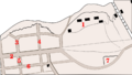
Bytown Plan, 1842. 1. Barracks Hill 2. Wellington Street 3. Victoria St.(now Lyon) 4. Kent St. 6. Sparks Street. Rideau Canal is on the top right.

