Little River (Shetucket River tributary) facts for kids
Quick facts for kids Little River |
|
|---|---|

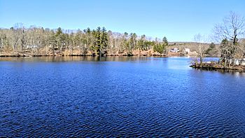
The Little River at Hanover Reservoir.
|
|
| Country | United States |
| State | Connecticut |
| Towns | Hampton, Scotland, Canterbury, Sprague, Norwich |
| Physical characteristics | |
| Main source | Hampton Reservoir, Hampton 41°29′33″N 72°01′58″W / 41.4925°N 72.0328°W |
| River mouth | Shetucket River, Occum, Norwich 41°21′15″N 72°01′30″W / 41.3542°N 72.0250°W |
| Length | 21.7 miles (34.9 km) |
| Width |
|
| Basin features | |
| Basin size | 30 square miles (78 km2) |
| Population | 8,000 |
| Tributaries |
|
| Waterbodies | Hanover Reservoir, Papermill Pond, Versailles Pond |
| Bridges | |
The Little River is a cool river in Connecticut. It flows through several towns. These towns include Hampton, Canterbury, Scotland, and Sprague.
The river starts at the Hampton Reservoir in northern Hampton. From there, it winds its way south. It eventually joins the Shetucket River. This happens where the towns of Norwich, Sprague, and Lisbon, CT meet.
About the Little River
The Little River is about 21.7 miles (35 kilometers) long. It's not a huge river, but it's an important part of the local environment. The area it drains, called its basin, is about 30 square miles (78 square kilometers). Around 8,000 people live in this area.
The river's width can change a lot. It can be as narrow as 12 feet (3.7 meters). But it can also spread out to 240 feet (73 meters) wide in some spots. On average, it's about 64 feet (19.5 meters) wide.
Where the Water Comes From
The Little River gets water from a few smaller streams. On its left side, it has a stream called Cedar Swamp Brook. On its right side, it gets water from Downing Brook and Peck Brook.
The river also flows through some larger bodies of water. These include the Hanover Reservoir, Papermill Pond, and Versailles Pond. These places are important for the river's flow and the wildlife around it.
Bridges and Crossings
Many roads and trails cross over the Little River as it flows through Connecticut. These crossings help people travel around the area. The entire river is located within the state of Connecticut.
Here is a list of some of the places where the Little River is crossed:
| County | Town | Crossing Name | Coordinates |
|---|---|---|---|
| Windham | Hampton | Airline State Park Trail | 41°49′20″N 72°03′25″W / 41.8223°N 72.0570°W |
| Kenyon Rd. | 41°49′13″N 72°03′24″W / 41.8204°N 72.0568°W | ||
| 41°48′23″N 72°03′22″W / 41.8064°N 72.0562°W | |||
| Old Kings Highway | 41°48′14″N 72°03′28″W / 41.8039°N 72.0578°W | ||
| Hammond Hill Rd. | 41°47′35″N 72°03′02″W / 41.7930°N 72.0506°W | ||
| N. Bigelow Rd. | 41°46′49″N 72°02′42″W / 41.7802°N 72.0450°W | ||
| E. Old Route 6 | 41°46′45″N 72°02′39″W / 41.7791°N 72.0443°W | ||
| 41°46′18″N 72°02′37″W / 41.7718°N 72.0436°W | |||
| Drain St. | 41°46′11″N 72°02′40″W / 41.7698°N 72.0444°W | ||
| Sand Hill Rd. | 41°45′33″N 72°02′57″W / 41.7593°N 72.0493°W | ||
| Windham Rd. | 41°44′36″N 72°03′09″W / 41.7432°N 72.0526°W | ||
| Scotland | None | ||
| Canterbury | 41°42′09″N 72°03′17″W / 41.7024°N 72.0548°W | ||
| Miller Goodwin Con. | 41°41′36″N 72°02′57″W / 41.6932°N 72.0492°W | ||
| Woodchuck Hill Rd. | 41°40′13″N 72°03′14″W / 41.6702°N 72.0538°W | ||
| New London | Sprague | Parkwood Rd. | 41°38′50″N 72°03′38″W / 41.6472°N 72.0605°W |
| Potash Hill Rd. | 41°38′21″N 72°03′28″W / 41.6391°N 72.0578°W | ||
| 41°36′54″N 72°02′32″W / 41.6150°N 72.0421°W | |||
| Providence and Worcester RR | 41°36′50″N 72°02′35″W / 41.6140°N 72.0430°W | ||
| Riverside Rd. | 41°35′59″N 72°02′44″W / 41.5998°N 72.0456°W | ||
| Main St./Inland Rd. | |||
| Norwich | None/ End of River | 41°35′41″N 72°02′51″W / 41.5947°N 72.0474°W |
 | James Van Der Zee |
 | Alma Thomas |
 | Ellis Wilson |
 | Margaret Taylor-Burroughs |

