
Neighborhoods of Norwich, Connecticut facts for kids
Norwich, Connecticut, is a city with many unique areas, often called neighborhoods. Each neighborhood has its own special feel and history. You can even see signs marking their borders! Let's explore some of these interesting places in Norwich.
Contents
Bean Hill
Bean Hill used to be a separate village, about a mile from the center of Norwich. It was started by a group of Episcopalian people around a small green area, which is now a public park. In the early 1800s, it had a Methodist church that also served as a school.
A famous African American abolitionist named David Ruggles grew up here. He even had a secret stop for the Underground Railroad in one of the houses in this area. Many old colonial houses and the original Methodist church building are still standing today.
Today, Bean Hill has grown a lot, especially with a highway exit nearby. This part is now busy with businesses like gas stations and a hotel. Further from the green, you'll find more shops and homes. A copper company called Phelps Dodge is also located in Bean Hill, near some old mills.
Chelsea or Downtown

Chelsea, also known as Downtown, is right where the Thames, Shetucket, and Yantic Rivers meet. This location made it a perfect spot for the city's old shipping harbor, which was on Hollyhock Island. Because Norwich was a big center for factories and trade, this neighborhood is quite large.
The heart of Downtown Norwich has the harbor and many old buildings from the 1700s. Many big businesses like the Wauregan Hotel and Sears used to be around Centennial Square. Over time, many of these businesses either closed or moved away.
You can find many churches and historic homes here. The old train station and tracks are also in Chelsea. The city's grand City Hall, built in 1870, is here, along with the New London County Superior Court and the Otis Library. The oldest building still standing in the city, Chelsea Landing Pub, is also located here.
Important public spaces include Centennial Square (also called Franklin Square), City Hall Square (also called Union Square), and Howard T. Brown Memorial Park. The offices for the Norwich Bulletin newspaper are in the old train station building.
After many factories moved away, Chelsea/Downtown faced tough times. Many buildings became empty and fell apart. To help bring life back, the area was renamed the Chelsea Arts District. This is because of the theaters and small art galleries that have opened here.
Some important buildings, like the Wauregan Hotel and Otis Library, have been beautifully fixed up. Hollyhock Island, once home to an abandoned factory, now has a marina for boats and a transportation center. The harbor area and Howard T. Brown Park are popular for summer music concerts and yearly festivals, like the Taste of Italy and Juneteenth.
East Great Plains (or Westside)
This part of Norwich is in the southwest and has been known as East Great Plains since at least 1890. It's centered around the meeting point of New London Turnpike and Route 82.
You'll find Three Rivers Community College here, which is a local college. There's also the Norwich Rose Garden Ice Rink for skating and the Norwich Public Golf Course. Stanton Elementary School is located in East Great Plains, next to Beth Jacob, one of Norwich's synagogues.
East Side
The East Side is located on the Shetucket River and the hills just northeast of Laurel Hill. This neighborhood is known for its diverse community. When it was first settled, many Italian immigrants lived here, followed by Polish families. More recently, Haitian, Hispanic, and Asian families have made this area their home. This mix of cultures makes it a true "melting pot," where new Asian grocery stores can be found next to old Italian shops.
A long time ago, before water pipes reached this area, people on the East Side got their water from a spring in the hills. The water flowed down to a public fountain where families would collect it. This fountain has recently been restored and is a landmark you can see from the intersection of Talman Street and East Main Street.
The Thames River Academy is also located on the East Side.
Greeneville
The Greeneville area of Norwich was named by William Greene. In 1826, he bought land on both sides of the Shetucket River to develop it. He later sold the land to the Norwich Water Power Company, where he was a major owner. This company built a dam and canals starting in 1829. By 1833, they were finished and could provide water power to many factories. Mills were quickly built along the Shetucket River to use this power. You can still see parts of the original dam upstream from the current one.
Greeneville was first settled by Irish immigrants. They built St. Mary's Church in 1845, making it the oldest Catholic church in eastern Connecticut. The original church building is now a hardware store. The current church, finished in 1867, is on Central Avenue. While it started with Irish families, it now also serves growing Hispanic and Haitian communities, offering masses in Spanish and Creole.
The Greeneville Dam Fishing Area lets people fish and boat on the Shetucket River. There's also a fish ladder and dam run by Norwich Public Utilities.
Greeneville has a committee that works to keep the area friendly for families and small businesses.
Jail Hill
Jail Hill is located just above downtown. This area used to have a prison on top of the hill. Now, it's a quiet neighborhood with winding streets. From here, you can get great views of the rest of the city.
Laurel Hill

Laurel Hill is across the river from Thamesville. It's mostly a residential area, meaning many homes are here. Most businesses and organizations are located along Route 12. Along the river, you'll find old warehouses and a former train yard. The building where the Thermos Corporation once had a factory has been turned into the Integrated Day Charter School.
The Norwich part of the former Norwich State Hospital, which was a large psychiatric hospital, is on the very south end of Laurel Hill. There's also an abandoned community that was part of the hospital.
Near the abandoned hospital, there's an apartment complex called Thames View Apartments. Right next to it is the Laurel Hill Volunteer Fire Department.
Veterans' Memorial Elementary School and the former Laurel Hill Neighborhood School are the main schools in this area.
Norwichtown
Norwichtown is in the north-central part of Norwich. This is the oldest part of Norwich, where the city's founders first settled. The Norwichtown Green is surrounded by many historic houses and shops. Some of these old buildings are now used as law offices, nursing homes, or bed and breakfasts.
The John Mason School, which is now the main office for the Norwich Public School System, and the First Congregational Church are also in Norwichtown. The neighborhood is part of the Norwichtown Historic District, which protects its historical buildings.
Occum
Occum is named after Samson Occom, a famous Native American minister. This was another "mill town" that later became part of Norwich. Like Greeneville, it's located on the Shetucket River. The old mill and dam here have been taken down.
Occum has a small business area with a fire station and a public park. The rest of the area is made up of homes and churches, stretching towards Baltic.
Ox Hill
Ox Hill is just northeast of Washington Street and Broadway. This area is mostly for homes and recreation. The Norwich Vocational Technical High School is located here. Thomas J. Kelly Junior High School is next to the vocational high school.
Across the road from Kelly Junior High are sports fields, courts, and parks used by the Norwich Recreation Department. The Rose City Senior Center and three broadcast towers are also on Ox Hill. The rest of the area is residential and connects to Norwichtown. Mohegan Park, a large park, is also located on Ox Hill.
Plain Hill
Plain Hill is a gently sloping hill on the edge of Norwich, just above Bean Hill. It reaches all the way to the border of Sprague. This area is completely residential and very rural. There's one main road, Plain Hill Road, with smaller side streets leading off it.
In the more forested parts, houses are spread out. In cleared areas, there are more homes and a radio tower. Some side streets lead to smaller groups of houses.
Wilcox Pond and Bog Meadow Reservoirs, which are two of the city's backup water sources, are located on Plain Hill.
The city's building for the Church of Jesus Christ of Latter-day Saints is also on Plain Hill, near the Sprague border.
Taftville

Taftville is named after the person who started a large textile mill here in 1866. It's north of Greeneville and west of the Shetucket River. Since the 1800s, Taftville has been a center for Norwich's French-Canadian population. Sacred Heart Church, on the main street (Providence Street), used to celebrate Catholic Mass in French for many years.
Thamesville
Thamesville gets its name from the Thames River. This neighborhood is mostly residential and offers views of Chelsea, Laurel Hill, the Marina (Norwich's former port), and the Thames and Yantic Rivers. It has small businesses along the river and homes mixed in along Route 32.
The Norwich Police Department and City Fire Department are at the northern end of Thamesville, providing quick help to this area and others nearby. The American Ambulance headquarters is also located here.
The Spa at Norwich Inn is in the southern part of Thamesville. It's a short walk or drive to the Mohegan Sun Casino Resort, which is further south on Route 32. Thamesville is also close enough to walk to many of the nightlife spots in Chelsea. It also has its own local places to eat and relax, like The Basement Cafe and Fat Cat's.
Near the Uncasville border, a line of car dealerships has given this part of Route 32 the nickname "The Auto Mall". Shipping Street, where an old oil company used to be, is one of Norwich's abandoned factory areas.
Thamesville is still growing. It used to be farmland and factory sites. In the 1800s, it started to become more residential. Most homes here are single-family houses, but there are also remodeled homes, apartment buildings, and condominiums.
Union Street and City Hall Square
This area is located between Chelsea and Washington Street and Broadway. It has two historic churches on City Hall Square. You'll also find several city offices and many houses stretching up the hill towards Little Plains Park. The City Hall Square part was originally known as Union Square.
Washington Street and Broadway
This neighborhood stretches along Washington Street and Broadway, between Chelsea and Norwichtown. During the city's busy times, like during the Civil War and after, this area became home to many wealthy people. Many large mansions, some of which are still standing, line Washington Street and Broadway. Smaller houses are on the side streets behind them.
When the economy slowed down, Washington Street and Broadway also faced challenges. The wealthy families left, and many mansions became run down. Recently, people have been working to improve the neighborhood. Many mansions have been repaired, and some have been turned into apartments.
The largest building in the city, Saint Patrick's Cathedral, is at the intersection of Broadway and Union Street. Irish immigrants to the city built this solid stone Roman Catholic cathedral. Its main steeple is the tallest structure in Norwich. Saint Patrick's property also includes its offices and Saint Patrick's School. Monsignor King Park, across the street, honors a former leader of the cathedral. Another important church here is Park Congregational Church.
The Norwich Free Academy, a large high school, is just north of Saint Patrick's on Broadway.

Chelsea Parade is the main park in Washington Street and Broadway. It has a Civil War Memorial, the city time capsule, and a flag pole. This area is mainly used as a war memorial and hosts the Memorial Day Parade and remembrance ceremonies. Columbus Park, with a small monument to Christopher Columbus, is next to Chelsea Parade. Across a small street from the parade is War Memorial Park, a small area with memorials to veterans of foreign wars and POW-MIAs.
Around Chelsea Parade, there used to be the Masonic Temple (which was taken down to protect an ancient Native American burial ground). There are also the Blackstone Apartments and smaller mansions. In the area of Sachem and Asylum Streets, you'll find Heritage Falls Park and Indian Leap. This is where a Native American captive from the Narragansett tribe famously leaped over the Yantic Falls while being chased by Mohegan Indians.
This district extends up to the Norwichtown welcome sign on Washington Street.
Between Norwichtown and the end of Washington Street is the William W. Backus Hospital. Opened in 1893, Backus Hospital is named after William Wolcott Backus, who helped lead the effort to build it. Today, Backus is the city’s largest non-government employer.
Yantic

This village is named after the Yantic River that flows through it. Yantic was originally an independent mill town with several mills, including the former Yantic Woolen Company Mill. It has small businesses, houses, some hotels, two highways, a railroad, a firehouse with picnic grounds, and the old mill buildings. The New England Central Railroad tracks cross the Yantic River in Yantic over a truss bridge.
Nearby, Sunnyside Street crosses the Yantic River over a unique stone bridge with two small towers at its western end. The Yantic Volunteer Fire Department is across from the former mill.
Because Yantic was a planned mill town, it has a grid pattern of streets with "mill house" duplexes (two homes in one building) and Grace Episcopal Church.
The last company to operate the mill was Hale Manufacturing Company, which stopped production in 1988. In the early 1990s, there was a plan to turn the mill into a resort hotel. However, this project faced many problems and was never completed.
Images for kids
-
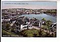
Harbor view, 1909
-
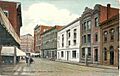
Shetucket Street, 1909
-
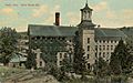
Yantic Woolen Company mill in 1912
-
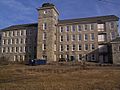
Hale Manufacturing Company mill


