
Talcott Mountain facts for kids
Quick facts for kids Talcott Mountain |
|
|---|---|

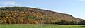
Talcott Mountain cliffs from the Farmington River floodplain. Heublein Tower top right.
|
|
| Highest point | |
| Elevation | ridge high point |
| Geography | |
| Location | Farmington, West Hartford, Avon, Bloomfield, and Simsbury, Connecticut |
| Parent range | Metacomet Ridge |
| Geology | |
| Age of rock | 200 Ma |
| Mountain type | Fault-block; igneous |
| Climbing | |
| Easiest route | Metacomet Trail |
Talcott Mountain is a cool mountain ridge in central Connecticut. It's about 13-mile (21 km) long and its highest point is 950 feet (290 m). You can find it about 6 miles (10 km) west of Hartford.
This mountain ridge has amazing cliffs on its western side. You can see them clearly from the Farmington River valley. Talcott Mountain is part of a long, narrow chain of mountains called the Metacomet Ridge. This ridge stretches all the way from Long Island Sound up through Massachusetts to the Vermont border.
People love Talcott Mountain for outdoor fun. It has special mini-ecosystems and rare plants. The cliffs offer huge views, rising up to 700 ft (213 m) above the land below.
Talcott Mountain includes two state parks and many town recreation spots. There are also reservoirs, a science center, a special forest, and the famous Heublein Tower. The 51-mile (82 km) long Metacomet Trail runs right along the ridge.
Contents
Exploring Talcott Mountain's Geography

Talcott Mountain is located across several towns. These include Farmington, West Hartford, Avon, Bloomfield, and Simsbury, Connecticut. The mountain ridge has cliffs facing west, with many bumps and peaks.
There are two main levels of cliffs along most of the mountain. Some parts have even more levels. Talcott Mountain is widest at 3 miles (5 km).
Some important peaks on the ridge are:
- The highest point, where the Heublein Tower stands, is 950 ft (290 m).
- Ely Mound is 820 ft (250 m) tall. It's a cone-shaped peak south of the main summit.
- Kilkenny Rocks is an open ledge 730 ft (223 m) high. It's near the southern end of the mountain.
- King Phillip Mountain is 920 ft (280 m) tall. It's just north of the main summit.
- Burnt Hill is a peak on the southeast side, 447 ft (136 m) high.
- The Pinnacle in Penwood State Park is 737 ft (225 m) tall.
Talcott Mountain is a key source of water for the Hartford area. Many reservoirs and ponds are on the mountain. These include Wash Brook Pond, Lake Louise, and Hartford Reservoirs #1, 2, 3, 5, and 6. Lake Louise is a special pond formed by a glacier. It has a boardwalk, a viewing platform, and a waterfall.
Several roads cross Talcott Mountain. These are Connecticut Route 4, U.S. Route 44, and Connecticut Route 185. Many smaller roads climb the southern parts of the mountain. You can also see communication towers on the peaks.
The Metacomet Ridge continues north from Talcott Mountain as Hatchett Hill. To the south, it becomes Farmington Mountain. Water from the north and west sides of Talcott Mountain flows into the Farmington River. This river then joins the Connecticut River and flows into Long Island Sound. The Farmington River runs along the western base of the mountain. It cuts through the Metacomet Ridge at the Tarriffville Gorge. Water from the east side of the mountain flows into the Park River. This also goes into the Connecticut River and then to Long Island Sound.
How Talcott Mountain Was Formed: Geology

Talcott Mountain is a high point on the Metacomet Ridge. This ridge was formed about 200 million years ago. It happened during the Triassic and Jurassic periods. The mountain is made of a type of rock called trap rock, also known as basalt. Basalt is a rock that comes from volcanic eruptions.
Basalt is usually dark, but the iron in it turns rusty brown when it touches air. This gives the cliffs a reddish look. Basalt often breaks into cool octagonal or pentagonal shapes. This makes it look like a stack of posts. You can see huge slopes of broken basalt rocks below many of the cliffs. These are very clear near the bottom cliffs west of Heublein Tower.
The basalt cliffs were formed by several huge lava flows. These flows were hundreds of feet deep. They came up through cracks in the Earth's surface. These cracks formed when North America started to pull away from Eurasia and Africa. These lava floods happened over 20 million years.
Between the eruptions, layers of sediment were laid down. These layers eventually turned into sedimentary rock. So, the mountain became like a "layer cake" of basalt and sedimentary rock. Later, the Earth's crust moved, and these layers tilted upward. Over time, the softer sedimentary layers wore away faster than the hard basalt layers. This left the tilted basalt edges exposed, creating the distinct ridge and dramatic cliffs we see today. Imagine a tilted layer cake with some of the frosting (the softer rock) removed!
Life on the Mountain: Ecosystems

Talcott Mountain has special microclimates that are rare in New England. The dry, hot upper parts of the ridge have oak savannas. These are often filled with chestnut oak trees and different grasses and ferns. Eastern red cedar trees, which like dry places, grow on the bare cliff edges.
Cooler slopes that face east often have large groups of eastern hemlock trees. These are mixed with oak-hickory forest trees, which are more common in the lower areas. Narrow, deep ravines filled with hemlocks block sunlight. This creates damp, cooler places where plants that like cold climates can grow. Slopes made of loose rock (called talus) have many nutrients. They support plants that need calcium, which are not common in eastern Connecticut.
Because the trap rock ridges create such different types of land, they are home to many rare plants and animals. Some of these are listed as rare by the state or even globally.
Unfortunately, an invasive species called the Hemlock Woolly Adelgid caused problems. It killed many large eastern hemlock trees in Penwood State Park on Talcott Mountain. In 2000, the Connecticut Department of Environmental Protection started removing dead and sick trees. This problem and the tree removal greatly changed the look of the forests in that part of the mountain.
The huge Pinchot Sycamore tree is at the foot of the mountain in Simsbury. Its trunk is 25 ft (8 m) across! It's a candidate for a "champion tree."
Talcott Mountain is also an important path for raptor (birds of prey) during their yearly migration.
Fun Things to Do: Recreation
Talcott Mountain is a very popular place for outdoor activities. People from the Hartford area and visitors love it. The mountain has many hiking trails. It also has clifftop overlooks with amazing views of the countryside to the west. You can explore rugged forests, two small waterfalls, and a boardwalk through a swamp. There are also pretty ponds and reservoirs, plus places for active fun.

Penwood State Park and Talcott Mountain State Park have miles of paved and dirt roads. These are only for walking. They also have many trails, including the 51 miles (82 km) (80 kilometres (50 mi)) blue-blazed Metacomet Trail. This trail is taken care of by the Connecticut Forest and Park Association. The parks are great for hiking, cross-country skiing, snowshoeing, picnicking, and other quiet activities.
Curtis H. Veeder, an inventor and outdoorsman, gave Penwood State Park to the state. He wanted the park to "be kept in a natural state." This way, people who love nature could enjoy it just like he did. He made many of the first trails in the park. Lake Louise, a beautiful pond on the ridge, was named after his wife.
The Metropolitan District Commission of Connecticut (MDC) manages over 3,000 acres (12 km2) on Talcott Mountain. This land is used for public water supply, protecting water sources, and open space. Besides providing drinking water, the MDC also manages hiking trails and dirt roads (no motorized vehicles). They also take care of the forests. MDC lands are open for hiking, picnicking, cross-country skiing, snowshoeing, bicycling, mountain biking, and other quiet activities. The MDC also has a special trail with information signs. They have helped bring bald eagle populations back to the area. However, swimming, boating, hunting, and fishing are not allowed on MDC lands.
Batterson Park is a park in West Hartford. It's on the southeast side of the mountain, next to Hartford Reservoir #1. This park has a baseball field, picnic areas, playgrounds, a swimming pond, and a boat launch. The towns of Bloomfield and Simsbury own a lot of land on the mountain's northeast and northwest sides. This includes town parks and water protection areas. The town of Farmington owns part of Burnt Hill on the southeast side. There's a rough trail there. The town of Avon owns park land on the west side of the mountain. They also have a lot of land along the Farmington River at the mountain's base.
Heublein Tower: A Historic Landmark

The most famous part of Talcott Mountain State Park is Heublein Tower. You can only reach the tower by hiking. It's a 1.25 miles (2 km) hike, which takes about 30 to 40 minutes. The tower is 165 ft (50 m) tall and stands 1,040 ft (317 m) above sea level. Gilbert F. Hueblein built it in 1914 as a summer home. It was designed to stand strong against winds of 100 miles per hour (161 km/h).
During World War II, the Hartford Times newspaper owned the tower. In the 1950s, it was mainly used as a radio beacon. In the 1960s, it was going to be sold for building houses. But thanks to conservation groups, the state of Connecticut, and the United States government, the tower became part of Talcott Mountain State Park in 1965.
The tower has been fixed up and is now a museum. It has old items and furniture from its past. Visitors can climb to the top for an amazing 360-degree view. On a clear day, you can see four different states! The tower is open for tours from Memorial Day to Labor Day, Thursday through Sunday, from 10 am to 5 pm. It's also open from Labor Day through the end of October, from 10 am to 5 pm.
Protecting Talcott Mountain: Conservation and Education
Talcott Mountain and its natural areas are most at risk from new homes being built, especially on the ridge tops. A lot of the mountain is protected as state park land or for water supply. But private owners still have a lot of land. This is especially true on the southwest side, where fancy homes are built along the ridge. There are also homes on the lower slopes of the north and west sides.
In 2000, Talcott Mountain was part of a study by the National Park Service. They were looking into creating a new National Scenic Trail. This trail is now called the New England National Scenic Trail. It would include the Metacomet-Monadnock Trail and the Mattabesett Trail and Metacomet Trail in Connecticut.
The Talcott Mountain Science Center is a non-profit education and research place. It's located on top of the ridge. It offers many programs for children. These programs cover topics like geology (the study of rocks), ecology (the study of living things and their environment), astronomy (the study of space), and meteorology (the study of weather).
Many local groups work to protect the land and nature of Talcott Mountain. The most important ones are the Connecticut Forest and Park Association, the Simsbury Land Trust, the Avon Land Trust, and the Farmington Land Trust.
Images for kids
-
Talcott Mountain cliffs from the Farmington River floodplain. Heublein Tower top right.
