Hatchett Hill facts for kids
Quick facts for kids Hatchett Hill |
|
|---|---|

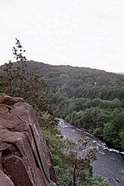
Tariffville Gorge from Hatchett Hill
|
|
| Highest point | |
| Elevation | 510 ft (160 m) |
| Parent peak | 41° 54' 20"N, 72° 45' 29"W |
| Geography | |
| Location | East Granby, Connecticut |
| Parent range | Metacomet Ridge |
| Geology | |
| Age of rock | 200 Ma |
| Mountain type | Fault-block; igneous |
| Climbing | |
| Easiest route | Metacomet Trail |
Hatchett Hill is a cool ridge in East Granby, Connecticut. It's about 11 miles (18 km) northeast of Hartford, Connecticut. This hill stands about 510 feet (155 meters) tall. It's part of a long, skinny line of hills called the Metacomet Ridge. This ridge stretches all the way from Long Island Sound in Connecticut, up through the Connecticut River Valley in Massachusetts, and even reaches the Vermont border!
The southern part of Hatchett Hill drops almost 200 feet (61 meters) straight down into a deep valley called the Tariffville Gorge. This ridge is famous for its rough, rocky shape, special tiny environments (called microclimates), rare plants, and as a path for raptors (like hawks and eagles) when they migrate. You can hike along the 51-mile (82 km) Metacomet Trail that goes right over the hill.
Where is Hatchett Hill?
Hatchett Hill is about 2.5 miles (4 km) long and 0.75 miles (1.2 km) wide. It has many rocky layers and steep cliffs. The highest point is 510 feet (155 meters) above sea level.
At its southern end, the hill has sharp cliffs that drop into the Tariffville Gorge. This is where the Farmington River has carved a deep channel between Hatchett Hill and Talcott Mountain to the south. You can also find Marsh Pond here. It's a lake formed by glaciers, nestled right in the middle of the ridge. From Hatchett Hill, the Metacomet Ridge continues north as Peak Mountain and south as Talcott Mountain.
The water on the northeast side of Hatchett Hill flows into the Connecticut River. From there, it goes into Long Island Sound. The rest of the hill's water flows into the Farmington River, which also eventually reaches the Connecticut River.
How Hatchett Hill Formed: Geology and Ecosystems
Hatchett Hill, like many parts of the Metacomet Ridge, is made of a type of rock called basalt. This rock is also known as trap rock and comes from volcanic activity. The mountain was formed about 200 million years ago, near the end of the Triassic Period. This was when the North American continent began to pull away from Africa and Eurasia.
During this time, hot lava flowed up from cracks in the Earth. This lava then cooled and hardened into thick layers of rock. Later, faults (cracks in the Earth's crust) and earthquakes caused these rock layers to tilt. This tilting created the steep cliffs and the long ridgeline we see today at Hatchett Hill.
The mountain has different types of environments:
- Hot, dry upper slopes
- Cool, moist ravines (small valleys)
- Mineral-rich ledges made of basalt talus (piles of broken rock)
These different conditions create special microclimate ecosystems. These tiny environments support plants and animals that are rare in other parts of Connecticut. Hatchett Hill is also a very important path for raptors (like hawks and eagles) when they fly south for the winter or north for the summer. You can learn more about the geology and ecosystems of this area on the Metacomet Ridge page.
Fun Activities and Protecting Hatchett Hill
Even though Hatchett Hill is one of the shorter peaks on the Metacomet Ridge, its sharp, rocky shape offers many beautiful views. The best view is from the top of the Tariffville Gorge. The Metacomet Trail goes right over Hatchett Hill. This trail is kept in good condition by the Connecticut Forest and Park Association. It stretches from the Hanging Hills in Meriden, Connecticut all the way to the Massachusetts border.
You can enjoy many outdoor activities on the ridge, such as:
- Hiking
- Bird watching
- Snowshoeing
- Other quiet outdoor activities
The natural environment and the ridgeline of Hatchett Hill are mainly threatened by new buildings and quarrying (digging up rock). In 2000, Hatchett Hill was part of a study by the National Park Service. They were looking into creating a new National Scenic Trail. This new trail is now called the New England National Scenic Trail. It would connect the Metacomet-Monadnock Trail in Massachusetts with the Mattabesett Trail and Metacomet Trail in Connecticut.
The East Granby Land Trust has worked hard to help protect Hatchett Hill and its beautiful viewshed (the area you can see from the hill).
 | Emma Amos |
 | Edward Mitchell Bannister |
 | Larry D. Alexander |
 | Ernie Barnes |

