
Mattabesett Trail facts for kids
Quick facts for kids Mattabesett Trail |
|
|---|---|

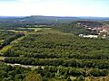
Higby Mountain along the Mattabesett Trail
|
|
| Length | 62.0 miles (99.8 km) |
| Location | Connecticut |
| Designation | National Scenic Trail, CFPA Blue-Blazed Trail |
| Trailheads | Start: River Road in Middletown, opposite power plant on Connecticut River. End: Berlin Turnpike in Berlin. |
| Use | hiking, trail running, cross-country skiing, snowshoeing, fishing, geocaching, other |
| Highest point | Higby Mountain north summit, 892 ft (272 m) |
| Lowest point | Connecticut River, Middletown, 18 ft (5.5 m) |
| Difficulty | Easy to difficult with a few dangerous ridge walk sections |
| Hazards | hunters, deer ticks, poison ivy |
The Mattabesett Trail is a 62-mile (100 km) long, hook-shaped Blue-Blazed hiking trail. You can find it in central Connecticut. It's also part of the bigger New England National Scenic Trail.
One part of the trail follows high, rocky ridges called the Metacomet Ridge. This section goes from Totoket Mountain in Guilford, Connecticut to Lamentation Mountain in Meriden, Connecticut. These ridges are famous for their amazing plants and animals, tall cliffs, and challenging hikes. The other part of the trail goes north from Guilford to Middletown, Connecticut, ending at the Connecticut River. This section has rolling hills, thick forests, and sometimes offers great views.
Some cool places you'll see along the trail include Lamentation Mountain, Chauncey Peak, Higby Mountain, and Besek Mountain. The Metacomet Trail continues north from Lamentation Mountain, picking up where the Mattabesett Trail ends.
The land, rocks, and nature along the Mattabesett Trail are much like those on the Metacomet-Monadnock Trail further north in Massachusetts.
In 2000, the United States Congress decided to look into creating a new National Scenic Trail. This new trail, now called the New England National Scenic Trail, would include the Mattabesett Trail. It would also connect to the Metacomet-Monadnock Trail and the Metacomet Trail.
On March 30, 2009, President Barack Obama signed a law that officially created the New England National Scenic Trail. This new trail will eventually include almost all of the "MMM" trails (Metacomet, Monadnock, and Mattabesett). It will also have a planned extension from the Mattabesett Trail's southern end to the Long Island Sound shore.
Contents
What to Do on the Trail
The Mattabesett Trail is great for many outdoor activities. People enjoy trail running, hiking, and backpacking. In winter, you can go snowshoeing.
You are not allowed to use bicycles on this trail. This rule applies to all Connecticut Blue-Blazed trails.
Some parts of the trail are good for cross-country skiing and geocaching. Other fun things to do include bird watching, hunting, fishing, and rock climbing.
Trail Towns
The Mattabesett Trail goes through several towns in Connecticut. These include Berlin, Middletown, Meriden, Middlefield, Wallingford, Connecticut, Durham, Connecticut, North Branford, Guilford, and Haddam.
History of the Trail
The Mattabesett Trail was the third trail made by the Connecticut Forest and Park Association. It was finished in 1932. Students from Wesleyan University helped clear the path and mark it with blue blazes.
Where the Name Comes From
The trail gets its name from the Mattabesset River. It's also named after the Wangunk Native American tribe, who lived in the Middletown area. They were sometimes called "Black-hill Indians."
Mattabesett was also the first name for Middletown when European settlers arrived. The name "Mete-wis" means "black earth."
Historic Places Along the Trail
You can find several interesting historic spots on the Mattabesett Trail:
- The Powder Ridge Ski area (you can see the ski lifts and slopes).
- Old stagecoach roads, like Stagecoach Road and Wadsworth Farm Road. People say George Washington used these roads a long time ago.
- Myerhuber Pond, which a farmer named Conrad Myerhuber dug with oxen.
- The Selectman's Stones, which mark the borders of Durham, Guilford, and Madison.
- The cellar ruins of the Pest House near the Mica Ledges in Durham.
Hiking the Trail Safely

The main trail is marked with blue rectangles. You can find guidebooks from the Connecticut Forest and Park Association that describe the trail.
The trail is kept in good shape. It's considered a moderately challenging hike because of the ups and downs. Some parts have rugged sections that can be difficult. The eastern section has some high ridge walks that can be dangerous, so kids should always have an adult with them.
Much of the trail is close to public roads. There are no places to camp along the trail, and camping is generally not allowed.
The weather on the trail is like typical Connecticut weather. On exposed ridge tops, it can be colder or stormier. Lightning can be a danger on high spots during thunderstorms. Snow is common in winter, so you might need snowshoes. Ice can form on rocky ledges, making hiking dangerous without special gear.
In late winter or early spring, ponds and streams can flood. This can make the trail very muddy, so waterproof boots are a good idea. Some southern and eastern parts of the trail follow old forest roads that can have deep ruts.
Biting insects can be annoying when it's warm. Be aware of deer ticks, which can carry Lyme disease.
Some parts of the trail are near or on land where hunting is allowed. It's a good idea to wear bright orange clothing during hunting season (fall through December) to stay safe.
Some very fast runners try to run the entire trail to set a time record!
Trail Recognition

The Connecticut Forest and Park Association (CFPA) gives out special patches to hikers. You can get a Mattabesett Trail patch for a small fee ($1) after you finish hiking the entire trail. Just contact the Connecticut Forest and Park Association.
Images for kids
-
View from Higby Mountain of Interstate 91 and the eastern quarry face of Chauncey Peak. In the far distance is Lamentation Mountain's long ridge.

