Haddam, Connecticut facts for kids
Quick facts for kids
Haddam
|
||
|---|---|---|
| Town of Haddam | ||

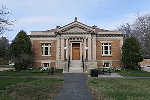
Brainerd Memorial Library
|
||
|
||
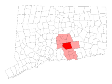
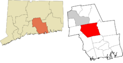
 Middlesex County and Connecticut Middlesex County and Connecticut |
||
| Country | ||
| U.S. state | ||
| County | Middlesex | |
| Region | Lower CT River Valley | |
| Incorporated | 1668 | |
| Government | ||
| • Type | Selectman-town meeting | |
| Area | ||
| • Total | 46.4 sq mi (120.2 km2) | |
| • Land | 44.0 sq mi (114.0 km2) | |
| • Water | 2.3 sq mi (6.0 km2) | |
| Elevation | 371 ft (113 m) | |
| Population
(2020)
|
||
| • Total | 8,452 | |
| • Density | 192/sq mi (74.1/km2) | |
| Time zone | UTC-5 (Eastern) | |
| • Summer (DST) | UTC-4 (Eastern) | |
| ZIP code |
06424, 06438, 06441
|
|
| Area codes | 860/959 | |
| FIPS code | 09-35230 | |
| GNIS feature ID | 0213439 | |
Haddam is a town in Middlesex County, Connecticut, United States. It's part of the Lower Connecticut River Valley Planning Region. In 2020, about 8,452 people lived here. Haddam is special because the Connecticut River flows right through its middle, unlike most towns where the river forms a border. It was also home to the Connecticut Yankee Nuclear Power Plant, which is now closed.
Contents
History of Haddam
Haddam is located in south-central Connecticut, along the lower Connecticut River. It's also home to a large part of Cockaponset State Forest, a beautiful natural area. The town was officially formed in October 1668. It was first called Hadham, but over time, the spelling changed to Haddam to match how people said it.
Haddam is unique because the Connecticut River divides it into two parts. Only two other towns along the entire Connecticut River are split this way. Haddam has five villages: Hidden Lake, Higganum, Shailerville, and Tylerville are on the west side of the river. Haddam Neck is on the east side. For its first 200 years, the Connecticut River was very important for travel and making money. Today, Haddam is mostly a place where people live.
The town was named after two places in England: Much Hadham and Little Hadham. These two places were known together as The Hadhams.
Haddam's Population Over Time
| Historical population | |||
|---|---|---|---|
| Census | Pop. | %± | |
| 1790 | 2,195 | — | |
| 1800 | 2,307 | 5.1% | |
| 1810 | 2,205 | −4.4% | |
| 1820 | 2,478 | 12.4% | |
| 1830 | 3,025 | 22.1% | |
| 1840 | 2,599 | −14.1% | |
| 1850 | 2,279 | −12.3% | |
| 1860 | 2,307 | 1.2% | |
| 1870 | 2,071 | −10.2% | |
| 1880 | 2,419 | 16.8% | |
| 1890 | 2,095 | −13.4% | |
| 1900 | 2,015 | −3.8% | |
| 1910 | 1,958 | −2.8% | |
| 1920 | 1,736 | −11.3% | |
| 1930 | 1,755 | 1.1% | |
| 1940 | 2,069 | 17.9% | |
| 1950 | 2,636 | 27.4% | |
| 1960 | 3,466 | 31.5% | |
| 1970 | 4,934 | 42.4% | |
| 1980 | 6,383 | 29.4% | |
| 1990 | 6,769 | 6.0% | |
| 2000 | 7,157 | 5.7% | |
| 2010 | 8,346 | 16.6% | |
| 2020 | 8,452 | 1.3% | |
| U.S. Decennial Census | |||
In 2000, there were 7,157 people living in Haddam. This included 2,701 households and 2,101 families. The town had about 162.5 people per square mile. Most of the people living in Haddam were White (96.86%). A small number were African American (1.03%), Asian (0.82%), or Native American (0.11%). About 1.06% of the population was Hispanic or Latino.
About 34.5% of households had children under 18 living with them. Most households (68.1%) were married couples. The average household had 2.64 people, and the average family had 3.00 people.
The population was spread out by age. About 24.7% were under 18 years old. About 30.4% were between 45 and 64 years old. The median age in Haddam was 40 years. This means half the people were older than 40 and half were younger.
Famous People from Haddam
Many interesting people have come from Haddam, including:
- Samuel Arnold, a politician
- David Brainerd, a missionary
- George Bradford Brainerd, an engineer, photographer, and nature historian
- Smith Clark, a lawyer and lawmaker
- Mary H. Dickerson, a businesswoman
- David Dudley Field II, a politician
- Stephen Johnson Field, a politician and judge
- Josiah J. Hazen, a college football player and coach
- Asahel W. Hubbard, a lawyer, judge, and politician
- David McDowell, a psychiatrist, author, and consultant
- Emil Planeta, an MLB baseball pitcher
- Alexander Shaler, a military general
- Venture Smith, an enslaved African who later became an author
- James Clark Walkley, a politician
Places to Visit in Haddam
Haddam has several notable locations and historic sites:
- Connecticut Yankee Nuclear Power Plant: This was once a nuclear power plant, but it is now closed.
- Higganum Landing Historic District: This area is listed on the National Register of Historic Places (NRHP).
- Camp Bethel: This historic religious camp was built in 1877. It is also listed on the NRHP. You can find it at 124 Camp Bethel Road.
- Haddam Center Historic District: The main village area of Haddam is recognized as a historic district on the NRHP.
- James Hazelton House: This historic house is also listed on the NRHP.
- Thankful Arnold House Museum: This museum is a stop on the Connecticut Women's Heritage Trail, celebrating women's history.
See also
 In Spanish: Haddam (Connecticut) para niños
 | Emma Amos |
 | Edward Mitchell Bannister |
 | Larry D. Alexander |
 | Ernie Barnes |


