
Chauncey Peak facts for kids
Quick facts for kids Chauncey Peak |
|
|---|---|

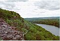
Cliffs of Chauncey Peak above Crescent Lake
|
|
| Highest point | |
| Elevation | 688 ft (210 m) |
| Parent peak | 41° 33' 31"N, 72° 45' 34"W |
| Geography | |
| Location | Meriden, Connecticut |
| Parent range | Metacomet Ridge |
| Geology | |
| Age of rock | 200 Ma |
| Mountain type | Fault-block; igneous |
| Climbing | |
| Easiest route | Mattabesett Trail |
Chauncey Peak is a cool mountain in Meriden, Connecticut. It's about 688 feet (209 meters) tall. This mountain is part of a long, narrow line of hills called the Metacomet Ridge. This ridge stretches all the way from Long Island Sound in Connecticut up to the border of Vermont. People love Chauncey Peak for its amazing views and tall cliffs that look over Crescent Lake. It also has special places where unique plants and animals live. You can hike on the Mattabesett Trail which goes right over the mountain.
Contents
Where is Chauncey Peak?
Chauncey Peak is located in the town of Meriden, Connecticut. It's about 0.75 miles (1.2 km) wide. Some people think it's part of Lamentation Mountain. But Chauncey Peak is actually its own mountain because it rises much higher than the land between them.
Crescent Lake and the Quarry
Crescent Lake is a beautiful lake nestled between Chauncey Peak and Lamentation Mountain. This lake is important because it provides emergency drinking water for the city of Meriden. A large part of the east side of the mountain has been used for quarrying. This means rocks are dug out from there.
Nearby Mountains and Rivers
The Metacomet Ridge continues north from Chauncey Peak to become Lamentation Mountain. To the south, it becomes Higby Mountain. The western side of Chauncey Peak drains into the Quinnipiac River. This river then flows into Long Island Sound. The eastern side drains into the Mattabesett River, which flows into the Connecticut River and then into Long Island Sound.
How Chauncey Peak Was Formed
Chauncey Peak and the whole Metacomet Ridge formed about 200 million years ago. This happened when North America and Eurasia started to pull apart. This pulling apart eventually created the Atlantic Ocean.
Lava Flows and Rock Formation
During this time, huge amounts of hot, melted rock (called lava) flowed across the land. These lava flows were hundreds of feet thick! This went on for about 20 million years. Between these lava flows, sand and mud collected. Over time, these sediments turned into sedimentary rock.
Cliffs and Ecosystems
After the land stopped pulling apart, the layers of rock tilted and broke. Over millions of years, erosion (like from wind and water) and glaciation (from glaciers) wore away the softer rocks. This left behind the harder lava rock, creating the tall cliffs we see today.
The special rock and shape of the ridge create different environments. Hot, dry cliffs are home to plants and animals not usually found so far north. Deep, cool valleys have species that like colder climates. The cliffs are also great places for raptors (like hawks and eagles) to live and travel.
Fun Things to Do and Protecting the Mountain

The west side of Chauncey Peak is part of Giuffrida Park. This park is managed by the city of Meriden. It has a lake, woodlands, and the rocky peaks of Lamentation Mountain and Chauncey Peak.
Activities in the Park
At Giuffrida Park, you can go hiking, snowshoeing, and cross-country skiing. It's also a nice place for picnicking and bicycling. However, swimming, boating, rock climbing, and fishing are not allowed.
The Mattabesett Trail
The park has many trails, including the famous Mattabesett Trail. This trail is maintained by the Connecticut Forest and Park Association. It stretches from the north end of Lamentation Mountain all the way south to Totoket Mountain. You can find parking for Chauncey Peak at Giuffrida Park on Westfield Road.
Protecting Chauncey Peak
The biggest threat to Chauncey Peak is the quarrying on its east side. However, the west side of the peak, which is inside Giuffrida Park, is protected. In 2000, Chauncey Peak was studied by the National Park Service. They were looking at including it in a new long-distance trail called the New England National Scenic Trail. This trail would connect other trails like the Metacomet-Monadnock Trail and the Mattabesett Trail.
Images for kids
-
Cliffs of Chauncey Peak above Crescent Lake
