Lamentation Mountain facts for kids
Quick facts for kids Lamentation Mountain |
|
|---|---|

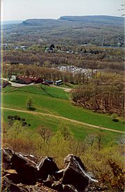
View of the Hanging Hills from Lamentation Mountain
|
|
| Highest point | |
| Elevation | 720 ft (220 m) |
| Parent peak | 41° 34' 27"N, 72° 45' 45"W |
| Geography | |
| Location | Middletown, Berlin, and Middlefield, Connecticut |
| Parent range | Metacomet Ridge |
| Geology | |
| Age of rock | 200 Ma |
| Mountain type | Fault-block; igneous |
| Climbing | |
| Easiest route | Mattabesett Trail |
Lamentation Mountain, also known as Mount Lamentation, is a cool traprock mountain in Connecticut. It stands about 720 feet (219 meters) tall. This mountain is located about 2.5 miles (4 km) north of Meriden, Connecticut.
Lamentation Mountain is part of the Metacomet Ridge. This is a long, narrow line of hills. It stretches from Long Island Sound near New Haven, Connecticut, all the way north to the Vermont border. The mountain is famous for its amazing views and tall cliffs. It also has special natural areas with unique plants and animals. The west-facing cliffs are over 200 feet (61 meters) high. Many people think the cliff walk here is one of the best in the state. A long path called the Mattabesett Trail crosses the mountain.
Contents
Why is it called Lamentation Mountain?
Lamentation Mountain got its name from an event in 1653. A person from a nearby town got lost on the mountain. They were missing for three days. Finally, a search party found them. This sad event led to the mountain's name.
Where is Lamentation Mountain?
Lamentation Mountain is about 3 miles (4.8 km) long. It is about 0.75 miles (1.2 km) wide. The mountain is located in three towns: Middletown, Berlin, and Meriden, Connecticut.
You can see Crescent Lake nearby. This lake used to be called Bradley Hubbard Reservoir. It sits between Lamentation Mountain and Chauncey Peak. The city of Meriden uses this lake for emergency drinking water. Silver Lake is also visible from the cliffs. It is in a low area between Lamentation Mountain and Cathole Mountain.
The Metacomet Ridge continues from Lamentation Mountain. To the west, it becomes Cathole Mountain. To the south, it becomes Chauncey Peak. The southern part of Lamentation Mountain drains into the Quinnipiac River. This river then flows into Long Island Sound. The northern part drains into the Mattabesett River. This river flows into the Connecticut River, which also goes to Long Island Sound.
How Lamentation Mountain Formed
Lamentation Mountain is made of a rock called basalt. Basalt is also known as traprock. It is a type of volcanic rock. The mountain formed about 200 million years ago. This was near the end of the Triassic Period. At that time, the continents of North America, Africa, and Eurasia were pulling apart.
Hot lava came up from deep inside the Earth. This lava cooled and hardened into thick layers of rock. Later, faults (cracks in the Earth) and earthquakes caused these rock layers to tilt. This tilting created the tall cliffs and ridges you see today on Lamentation Mountain.
Special Plants and Animals
Lamentation Mountain has unique natural areas. These areas are called microclimate ecosystems. They have different conditions, like hot, dry slopes and cool, moist valleys. These varied conditions allow many different plant and animal species to live here. Some of these species are rare in Connecticut.
The mountain is also an important path for raptors. Raptors are birds like hawks and eagles. They use this path when they migrate (travel) between different places.
Fun Things to Do and Protecting the Mountain
The southern part of Lamentation Mountain is inside Giuffrida Park. The city of Meriden manages this park. The park has a lake, a golf course, and lots of woodlands. You can also explore the rocky peaks of Lamentation Mountain and Chauncey Peak here.
In the park, you can go hiking, snowshoeing, and cross-country skiing. You can also have a picnic or go bicycling. However, you cannot swim, boat, or fish in Crescent Lake. Rock climbing is not allowed in the park area. But it is allowed in other parts of the mountain.
The Mattabesett Trail is a famous path in the park. It is 50 miles (80 km) long. It stretches from the north end of Lamentation Mountain south to Totoket Mountain. It then goes north again to the Connecticut River. The Metacomet Trail is another path that connects to the Mattabesett Trail. The Connecticut Forest and Park Association helps take care of both trails.
You can find parking for Lamentation Mountain at Giuffrida Park. It is on Westfield Road. You can also park near Spruce Brook Road in Berlin.
In 2000, Lamentation Mountain was part of a study. The National Park Service was looking at creating a new National Scenic Trail. This new trail is now called the New England National Scenic Trail. It would include the Metacomet-Monadnock Trail in Massachusetts and the Mattabesett and Metacomet trails in Connecticut.
Groups like the Berlin Land Trust and the Meriden Land Trust work to protect Lamentation Mountain. They help keep its beautiful views safe for everyone.
 | Kyle Baker |
 | Joseph Yoakum |
 | Laura Wheeler Waring |
 | Henry Ossawa Tanner |

