Totoket Mountain facts for kids
Quick facts for kids Totoket Mountain |
|
|---|---|

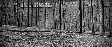
View from Totoket Mountain facing west towards the Farm River Valley from the Regional Water Authority's Green (Vista) Trail in the Big Gulph Recreation Area.
|
|
| Highest point | |
| Elevation | est. 720 feet (220 m) ridge high point |
| Geography | |
| Location | Durham, North Branford, and Guilford, Connecticut |
| Parent range | Metacomet Ridge |
| Geology | |
| Age of rock | 200 million years |
| Mountain type | Fault-block; igneous |
| Climbing | |
| Easiest route | Mattabesett Trail |
Totoket Mountain is a special kind of mountain made of a rock called traprock. Its highest point is about 720 feet (220 m) above sea level. You can find it about 7 miles (11 km) northeast of New Haven, Connecticut.
This mountain is part of the Metacomet Ridge, a long chain of mountains that stretches from Long Island Sound all the way north to the Vermont border. Totoket Mountain is famous for its tall, scenic cliffs, which are about 500-foot-high (150 m). It also has unique natural areas called microclimates, where rare plants grow. A large public lake, Lake Gaillard, is almost completely surrounded by the mountain.
The northern part of Totoket Mountain has many trails, including a section of the 50-mile (80 km) Mattabesett Trail. The name "Totoket Mountain" can mean the whole mountain or a smaller peak within it, which is about 577 feet (176 m) tall.
Contents
Exploring Totoket Mountain's Landscape
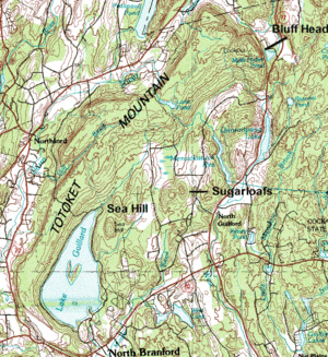
Totoket Mountain rises sharply from 200 ft (61 m) to 650 ft (198 m) above the land around it. Its highest point is about 720 ft (219 m) above the sea. The mountain is roughly 11.5 miles (18.5 km) long and 4.25 miles (10 km) wide at its widest part. It is located across three towns: Durham, North Branford, and Guilford, Connecticut.
Important Peaks and Water Bodies
Some of the main peaks on Totoket Mountain include:
- Sea Hill (410 feet (120 m))
- East and West Sugarloaf Hill (512 and 476 feet (156 and 145 m))
- Totoket Mountain (a smaller peak at 577 feet (176 m))
- Bluff Head (about 720 feet (220 m)), which is the highest point.
The southern part of the mountain forms two arms that wrap around Lake Gaillard. Besides Lake Gaillard, the mountain also protects several other small lakes and ponds. These include Menuckatuck Reservoir, West Lake, Clear Lake, Bartlett Pond, Lane Pond, and the beautiful Myerhuber Pond. Myerhuber Pond is part of the Northwoods conservation area, located just below the high cliffs of Bluff Head.
Where Totoket Mountain Connects
To the north, the Metacomet Ridge continues as Pistapaug Mountain. To the south, it becomes Saltonstall Mountain. There's also another peak called Peter's Rock to the west of Totoket Mountain.
Water flows off Totoket Mountain in different directions. On the west side, water drains into the Farm River. On the south side, it goes into the Branford River. The east side drains into the West River. All these rivers eventually flow into Long Island Sound. On the north side, water flows into Parmalee Brook, then to the Coginchaug River, and finally to the Connecticut River before reaching Long Island Sound.
How Totoket Mountain Was Formed
Totoket Mountain and the entire Metacomet Ridge began to form about 200 million years ago. This was when the huge landmasses of North America and Eurasia started to pull apart. This process eventually created the Atlantic Ocean.
Ancient Lava Flows and Rock Formation
In the area where the Metacomet Ridge is now, hot, melted rock called basalt (also known as traprock) flowed out of the ground. These lava flows were very thick, sometimes hundreds of feet deep. This happened over a period of 20 million years. Between these lava flows, layers of mud and sand built up. Over time, these layers hardened into sedimentary rock.
After the land stopped pulling apart, the layers of rock broke and tilted upwards. Over millions of years, wind, water, and ice (from glaciers) wore away the softer rocks. This left behind the harder traprock lava sheets, creating the steep cliffs we see today.
Unique Habitats and Wildlife
The special minerals in the traprock and the shape of the ridge create many different small natural areas, called microclimates.
- Hot, dry cliff faces are home to plants and animals that are not usually found so far north.
- Deep, cool valleys support species that prefer colder climates, like those found further north.
- Gentle slopes have plants and animals typical of the surrounding area.
- Piles of rocks at the base of cliffs collect minerals that help special plants grow. These plants like alkaline (non-acidic) soil, which is rare in southern New England.
- The many cliffs are also perfect homes and travel routes for raptors, like hawks and eagles.
To learn more about the geology and natural systems of Totoket Mountain, you can check out the main article on the Metacomet Ridge.
Protecting and Enjoying Totoket Mountain
Totoket Mountain is a great place for outdoor activities. People enjoy hiking, mountain biking, and snowshoeing there. You can also go hunting (during certain seasons) and fishing (in specific spots). Many of the high cliffs offer amazing views of the countryside.
Trails and Access
The South Central Connecticut Regional Water Authority (SCCRWA) manages two trail systems on the mountain:
- Big Gulph is on the northwest side.
- Sugarloaf Hills is in the middle of the ridge.
You need a permit (which costs money) to use these trails.
The Northwoods area, near Bluff Head on the northeast side, is managed by the Guilford Land Trust. It's free to visit. Here, you can see 500 ft (152 m) tall basalt cliffs and a firetower with wide-open views. The 50 miles (80 km) Mattabesett Trail also goes over Bluff Head and through the Northwoods area. Another trail entrance is located between Pistapaug Mountain and Totoket Mountain.
Conservation Efforts
A large part of the mountain is protected as a public watershed, which means it helps supply clean drinking water. The rest of the land is mostly rural, with some farms and homes. The SCCRWA limits public access to certain parts of its watershed land. For example, you are not allowed to boat or fish on Lake Gaillard.
Totoket Mountain's unique natural areas face some challenges. These include new housing developments spreading out from towns and rock quarrying. A large quarry operates on the southwest side of the mountain. However, its expansion is limited by the protected watershed land and nearby homes.
In 2000, the northern part of Totoket Mountain was studied by the National Park Service. They were looking into creating a new long-distance trail called the New England National Scenic Trail. This trail would connect the Metacomet-Monadnock Trail in Massachusetts with the Mattabesett Trail and Metacomet Trail in Connecticut.
Finding Trailheads and Parking
- Northwoods-Bluff Head parking lot: You can find this on Connecticut Route 77. It's about 3.75 miles (6.04 km) south of Durham center and 9 miles (14 km) north of Guilford center. The Mattabesett Trail starts here.
- Mattabesett Trail (Route 17 access): Another way to get on the Mattabesett Trail is from Connecticut Route 17. This spot is about 4 miles (6 km) east of Northford center and 3.3 miles (5.3 km) west of the Route 77 junction. You can park along the road here.
- Big Gulph trailhead: This is located behind the Northford Park recreation fields on Connecticut Route 17. It's about 2.2 miles (3.5 km) east of Northford center and 5.4 miles (8.7 km) west of the Route 77 junction. Parking is free, but you need a permit to use the trails.
- Sugarloaf Hills trailhead: This parking lot is on West Street, about 2 miles (3 km) north of where it meets Connecticut Route 80 in North Branford. You need a permit to park and use these trails.
 | Jackie Robinson |
 | Jack Johnson |
 | Althea Gibson |
 | Arthur Ashe |
 | Muhammad Ali |


