Pistapaug Mountain facts for kids
Quick facts for kids Pistapaug Mountain |
|
|---|---|

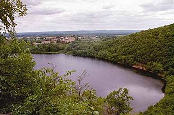
Pistapaug Pond from Pistapaug Mountain
|
|
| Highest point | |
| Elevation | est. 700 ft (210 m) |
| Parent peak | 41° 26' 00"N, 72° 44' 13"W |
| Geography | |
| Location | Durham and Wallingford, Connecticut |
| Parent range | Metacomet Ridge |
| Geology | |
| Age of rock | 200 Ma |
| Mountain type | Fault-block; igneous |
| Climbing | |
| Easiest route | Mattabesett Trail |
Pistapaug Mountain, also called Paug Mountain, is about 700 feet (210 m) (213 m) tall. This mountain is located about 11 miles (18 km) northeast of New Haven, Connecticut. It is part of a long, narrow chain of mountains called the Metacomet Ridge. This ridge stretches from Long Island Sound in Connecticut all the way north to the Vermont border.
Pistapaug Mountain is famous for its rough, rocky shape and amazing views from its cliffs. It also has special natural areas called microclimate ecosystems. These areas support rare plants and animals. The mountain rises steeply 300 feet (91 m) above Pistapaug Pond and the Quinnipiac River valley. A hiking path called the 50-mile (80 km) Mattabesett Trail goes right over the mountain.
Where is Pistapaug Mountain?
Pistapaug Mountain is mostly in the town of Durham. It is about 2 miles (3.2 km) long and 0.5 miles (0.8 km) wide. But because it has so many hills and valleys, its actual area feels much bigger. The Metacomet Ridge continues north from Pistapaug Mountain as Fowler Mountain. To the south, it becomes Totoket Mountain.
Pistapaug Mountain is important for water. Pistapaug Pond, which is at the base of the mountain, provides drinking water for the area. The mountain is mostly covered in trees. However, there are a few spots on the cliffs where you can see great views. From these spots, you can look west over Pistapaug Pond and the Quinnipiac River Valley.
The western part of Pistapaug Mountain sends its water into the Farm River. This river then flows into the East Haven River and finally into Long Island Sound. The eastern side of the mountain drains into Parmalee Brook. This brook then joins the Coginchaug River, which flows into the Connecticut River and also ends up in Long Island Sound.
How Pistapaug Mountain Formed and Its Ecosystems
Pistapaug Mountain is made of a type of rock called basalt, also known as traprock. This rock formed from lava that came out of the ground. This happened about 200 million years ago, at the end of the Triassic Period. At that time, the continents of North America, Africa, and Eurasia were pulling apart.
Lava flowed out from these cracks in the Earth. It then cooled and hardened into thick layers of rock. Later, earthquakes and faulting (where parts of the Earth's crust slide past each other) tilted these rock layers. This tilting created the steep cliffs and the ridgeline we see today on Pistapaug Mountain.
The mountain has different types of environments. For example, some upper slopes are hot and dry. Other areas, like ravines, are cool and moist. There are also rocky ledges made of basalt talus (broken rock pieces). These different conditions create special microclimate ecosystems. These ecosystems support plants and animals that are rare in other parts of Connecticut. Pistapaug Mountain is also a key spot for raptors (like hawks and eagles) when they migrate. You can find more details about the geology and ecosystems of this area in the Metacomet Ridge article.
Fun Activities and Protecting the Mountain
Most of the eastern side of Pistapaug Mountain is private land. However, the western side is public land used to protect the water supply. The Mattabesett Trail runs along the top of Pistapaug Mountain. This trail is maintained by the Connecticut Forest and Park Association. It stretches from Lamentation Mountain in the north, goes south to Totoket Mountain, and then north again towards the Connecticut River.
On the Mattabesett Trail, people enjoy activities like hiking and snowshoeing. It's also a great place for picnicking and other quiet outdoor activities. Please note that Pistapaug Pond is not open to the public.
To find the Mattabesett Trail for Pistapaug Mountain, you can go to Connecticut Route 17. The trailhead is located between Totoket Mountain and Pistapaug Mountain. It's about 4 miles (6.4 km) east of Northford center and 3.3 miles (5.3 km) west of the junction with Connecticut Route 77. There is parking available along Route 17.
The natural areas and ridgeline of Pistapaug Mountain are most at risk from new buildings and development. In 2000, Pistapaug Mountain was part of a study by the National Park Service. They were looking into creating a new National Scenic Trail. This trail is now planned to be called the New England National Scenic Trail. It would connect the Metacomet-Monadnock Trail in Massachusetts with the Mattabesett Trail and Metacomet Trail in Connecticut.
Groups like the Middlesex Land Trust and the Wallingford Land Trust have been working hard to protect the beautiful viewshed (the area you can see) of Pistapaug Mountain.
 | Georgia Louise Harris Brown |
 | Julian Abele |
 | Norma Merrick Sklarek |
 | William Sidney Pittman |

