
Durham, Connecticut facts for kids
Quick facts for kids
Durham, Connecticut
|
||
|---|---|---|
| Town of Durham | ||

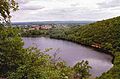
View from Pistapaug Mountain
|
||
|
||
 Middlesex County and Connecticut Middlesex County and Connecticut Lower Connecticut River Valley Planning Region and Connecticut Lower Connecticut River Valley Planning Region and Connecticut |
||
| Country | ||
| U.S. state | ||
| County | Middlesex | |
| Region | Lower CT River Valley | |
| Incorporated | 1708 | |
| Government | ||
| • Type | Selectman-town meeting | |
| Area | ||
| • Total | 23.8 sq mi (61.6 km2) | |
| • Land | 23.6 sq mi (61.1 km2) | |
| • Water | 0.2 sq mi (0.4 km2) | |
| Elevation | 161 ft (49 m) | |
| Population
(2020)
|
||
| • Total | 7,152 | |
| • Density | 303.1/sq mi (117.0/km2) | |
| Time zone | UTC-5 (Eastern) | |
| • Summer (DST) | UTC-4 (Eastern) | |
| ZIP code |
06422
|
|
| Area code(s) | 860/959 | |
| FIPS code | 09-20810 | |
| GNIS feature ID | 0213419 | |

Durham (/ˈdɜːrəm/ DURR-əm) is a historic town in Middlesex County, Connecticut, United States. It used to be a farming village. Durham is located on the Coginchaug River in central Connecticut.
The town is part of the Lower Connecticut River Valley Planning Region. In 2020, the population was 7,152 people. Every autumn, Durham hosts the Durham Fair. This is the largest volunteer agricultural fair in New England.
The center of Durham is recognized as a census-designated place. The main part of the town center is also a historic district. It is listed on the National Register of Historic Places.
Contents
Exploring Durham's Geography
Durham covers about 23.8 square miles (61.6 km2). Most of this area, about 23.6 square miles (61.1 km2), is land. Only a small part, 0.2 square miles (0.4 km2), is water.
Mountains and Trails in Durham
The western side of Durham has a mountain range called the Metacomet Ridge. This ridge is made of a type of rock called trap rock. It stretches from Long Island Sound all the way to the Vermont border.
Important mountains in Durham that are part of this ridge include Trimountain, Fowler Mountain, Pistapaug Mountain, and the northern tip of Totoket Mountain. A long hiking path, the 50-mile (80-kilometer) Mattabesett Trail, goes across this ridge. Miller's Pond State Park is also located within Durham.
Durham's Rich History

Durham became an official town in 1708. It was named after Durham, England. The town was formed using land from nearby Guilford and Haddam.
Early Public Library
Durham is home to one of the first public libraries in the United States. It was started in 1733. This was just two years after Benjamin Franklin opened a library in Philadelphia.
Notable Figures from Durham
Moses Austin was born in Durham in 1761. He was a businessman who worked with lead. Moses Austin, along with his son Stephen F. Austin, helped start the settlement of Spanish and Mexican Texas by Anglo-Americans.
Durham's Population Over Time
| Historical population | |||
|---|---|---|---|
| Census | Pop. | %± | |
| 1790 | 1,079 | — | |
| 1800 | 1,029 | −4.6% | |
| 1810 | 1,101 | 7.0% | |
| 1820 | 1,210 | 9.9% | |
| 1830 | 1,116 | −7.8% | |
| 1840 | 1,095 | −1.9% | |
| 1850 | 1,026 | −6.3% | |
| 1860 | 1,130 | 10.1% | |
| 1870 | 1,086 | −3.9% | |
| 1880 | 990 | −8.8% | |
| 1890 | 856 | −13.5% | |
| 1900 | 884 | 3.3% | |
| 1910 | 997 | 12.8% | |
| 1920 | 959 | −3.8% | |
| 1930 | 1,044 | 8.9% | |
| 1940 | 1,098 | 5.2% | |
| 1950 | 1,804 | 64.3% | |
| 1960 | 3,096 | 71.6% | |
| 1970 | 4,489 | 45.0% | |
| 1980 | 5,143 | 14.6% | |
| 1990 | 5,732 | 11.5% | |
| 2000 | 6,627 | 15.6% | |
| 2010 | 7,388 | 11.5% | |
| 2020 | 7,152 | −3.2% | |
| U.S. Decennial Census | |||
In 2000, there were 6,627 people living in Durham. There were 2,277 households and 1,871 families. About 41.2% of households had children under 18 living with them.
The population was spread out by age. About 29.0% were under 18 years old. About 9.5% were 65 years or older. The average age in Durham was 38 years.
Durham Town Center Population
The Durham census-designated place, which is the town center, had 2,773 people in 2000. There were 1,040 households. About 36.7% of these households had children under 18.
The average age in the town center was 40 years. About 26.1% of the population was under 18. About 13.0% were 65 years or older.
Historic Places in Durham


Durham has several important historic locations:
- Elias Austin House
- Thomas Lyman House
- Main Street Historic District: This area in the town center is known for its beautiful old houses and their architecture.
Environmental Cleanup Efforts
There is an area in Durham called the Durham Meadows superfund site. This site includes locations where companies used to operate. These companies had disposed of certain wastes, like solvents and paint wastes.
Over time, these wastes affected the town's water supply. This led to some private wells having certain chemicals in them. The U.S. Environmental Protection Agency and Connecticut Department of Environmental Protection are working together to clean up the area. They are also monitoring the situation. They even provided free bottled water to affected residents.
Famous People from Durham
Many interesting people have connections to Durham:
- Moses Austin (1761–1821): Born in Durham, he was a businessman.
- Stephen F. Austin: The son of Moses Austin, he is known as the founder of Texas.
- Vin Baker (born 1971): A professional basketball player who played in the National Basketball Association.
- Dwight Baldwin (1798–1886): A missionary who worked in Hawaii.
- Chauncey Goodrich (1759–1815): A lawyer and politician.
- Elizur Goodrich (1761–1849): Also a lawyer and politician.
- Vernon "Lefty" Gomez: A famous baseball player for the New York Yankees. He is in the Hall of Fame.
- Phineas Lyman (1716–1774): A major general in the Connecticut militia during the French and Indian War.
- Charles D. Madsen: A Wisconsin State Senator.
- James C. Scott (born 1936): A political scientist and anthropologist.
- James Wadsworth (1730–1816): A lawyer and a delegate to the Continental Congress in 1784.
Images for kids
-
View from Pistapaug Mountain
See also
 In Spanish: Durham (Connecticut) para niños
