
Trimountain facts for kids
Quick facts for kids Trimountain |
|
|---|---|

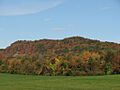
Trimountain west facing side
|
|
| Highest point | |
| Elevation | (est.) 760 ft (230 m) |
| Parent peak | 41° 27' 37"N, 72° 44' 10"W |
| Geography | |
| Location | Durham and Wallingford, Connecticut |
| Parent range | Metacomet Ridge |
| Geology | |
| Age of rock | 200 Ma |
| Mountain type | Fault-block; igneous |
| Climbing | |
| Easiest route | Mattabesett Trail |
Trimountain (also called Tri-mountain) is a cool mountain made of a special rock called traprock. It's about 760 feet (230 m) tall and is located near Meriden, Connecticut. This mountain is part of a long, narrow chain of hills called the Metacomet Ridge. This ridge stretches from Long Island Sound all the way north through Connecticut and Massachusetts to the Vermont border.
Trimountain is famous for its amazing cliff faces and unique natural areas. It has special "microclimate" ecosystems, which are like tiny weather zones that support rare plants. A long hiking path, the 51-mile (82 km) Mattabesett Trail, goes right over the mountain.
Contents
Where is Trimountain Located?
Trimountain is found in the towns of Durham and Wallingford, Connecticut. It gets its name because it looks like a triangle and has three main peaks at its southern end. There are also three dips or "notches" between these peaks.
This mountain stands out, rising about 500 feet (150 m) above the land around it. Trimountain is roughly 1.5 miles (2.4 km) long and 1 mile (1.6 km) wide. Even though some parts of the mountain have been changed by quarrying (where rock is dug out), the Mattabesett Trail still lets you explore its southern peaks and wooded eastern side.
North of Trimountain, the Metacomet Ridge continues as Besek Mountain. To the south, it becomes Fowler Mountain. Water from the east side of Trimountain flows into the Coginchaug River, then into the Connecticut River, and finally reaches Long Island Sound. Water from the west side goes into the Muddy River, then the Quinnipiac River, also ending up in Long Island Sound.
How Trimountain Formed and What Lives There
Trimountain, like many parts of the Metacomet Ridge, is made of a hard, dark rock called basalt (or traprock). This rock formed from lava that came out of the ground about 200 million years ago. This happened during the Triassic Period when the huge continents of North America, Africa, and Eurasia began to pull apart.
As the lava cooled, it turned into thick layers of rock. Later, big ground movements and earthquakes tilted these rock layers. This created the steep cliffs and the long ridgeline we see today on Trimountain.
The mountain has different types of small natural areas, called microclimates. For example, some slopes are hot and dry, while ravines are cool and wet. These different conditions, along with the mineral-rich basalt rock, create a home for plants and animals that are not common in other parts of Connecticut. Trimountain is also an important path for raptors (like hawks and eagles) when they migrate. You can learn more about the geology and ecosystem of this area on the Metacomet Ridge page.
Fun Activities and Protecting Trimountain
Trimountain is a great place for outdoor activities! People enjoy hiking, cross-country skiing, and snowshoeing here. The 50-mile (80 km) Mattabesett Trail goes across the mountain. This trail is cared for by the Connecticut Forest and Park Association. It stretches from Lamentation Mountain in the north, south to Totoket Mountain, and then north again to the Connecticut River.
There's also an undeveloped area called Trimountain State Park on the southeastern side of the mountain. You can find a starting point for the Mattabesett Trail where Connecticut Route 68 and Connecticut Route 157 meet in Reeds Gap. This spot is between Trimountain and Besek Mountain, about 3 miles (5 km) west of Durham center.
The main threats to Trimountain's ridgeline and its unique ecosystem are quarrying and new buildings. The quarry on the western side of the mountain was quite large in 2007, about 0.75 by 0.8 miles (1,210 by 1,290 m).
In 2000, Trimountain was part of a study by the National Park Service. They were looking into creating a new long-distance path called the New England National Scenic Trail. This trail would connect the Metacomet-Monadnock Trail in Massachusetts with the Mattabesett Trail and Metacomet Trail in Connecticut.
Local groups like the Wallingford Land Trust and the Middlesex Land Trust are working hard to protect the beautiful views from Trimountain.
Images for kids
-
Trimountain west facing side
