
Besek Mountain facts for kids
Quick facts for kids Besek Mountain |
|
|---|---|

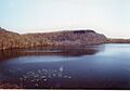
Cliffs of Besek Mountain plunge into Black Pond
|
|
| Highest point | |
| Elevation | c. 840 feet (256 m) (ridge high point) |
| Geography | |

Besek Mountain
Location in Connecticut
|
|
| Parent range | Metacomet Ridge |
| Geology | |
| Age of rock | 200 Ma |
| Mountain type | Fault-block; igneous |
| Climbing | |
| Easiest route | Mattabesett Trail |
Besek Mountain, also known as Black Mountain, stands about 840 feet (256 meters) tall. It's a special type of mountain called a traprock mountain ridge. You can find it about 4.75 miles (7.6 kilometers) southeast of Meriden, Connecticut.
This mountain is part of a long, narrow line of hills called the Metacomet Ridge. This ridge stretches all the way from Long Island Sound near New Haven, Connecticut, up through the Connecticut River Valley to the Vermont border. Besek Mountain is famous for its long cliffs, which are about 3 miles (5 kilometers) long. It also has unique natural areas called microclimate ecosystems and rare plant communities. A hiking path called the Mattabesett Trail, which is 51 miles (82 kilometers) long, crosses the mountain. You can also find the Powder Ridge Ski Area here.
Contents
Exploring Besek Mountain's Landscape
What's in a Name?
The name "Besek" comes from an old Native American word, "Besett," which means "black." This might be because of the dark rocks found on the mountain.
Size and Location
Besek Mountain is about 4 miles (6.4 kilometers) long and 0.75 miles (1.2 kilometers) wide. It has a continuous cliff line that is 200–300 feet (60–90 meters) high and 3 miles (5 kilometers) long. You can see these cliffs from far away! The mountain is located in the towns of Meriden, Middlefield, and Wallingford, Connecticut. Its lower southeast side is in Durham, Connecticut.
Beautiful Ponds and Lakes
One of the most beautiful spots is Black Pond, on the northwest side of the mountain. The cliffs and rocky slopes drop about 200 feet (60 meters) right into the pond. Other water bodies include Besek Lake on the east side and the lower part of Mount Higby Reservoir to the north.
Skiing and Views
The Powder Ridge Ski Area is on the east side of the mountain and goes all the way to the top. Part of the mountain, called Powder Ridge or Powder Hill, is about 550 feet (168 meters) high. This area has apple orchards and farms. Powder Hill Road offers amazing views to the east over the Connecticut River Valley. It's a popular spot for a scenic drive.
Neighboring Mountains and Water Flow
To the north, the Metacomet Ridge continues as Higby Mountain. To the south, it becomes Trimountain. Water from the east side of Besek Mountain flows into the Coginchaug River, then into the Connecticut River, and finally into Long Island Sound. Water from the southwest side goes into the Muddy River, then the Quinnipiac River, and also into Long Island Sound. The northwest side drains into Harbor Brook, which then flows into the Quinnipiac River.
How Besek Mountain Was Formed and Its Wildlife
Mountain Building Blocks
Besek Mountain, like many parts of the Metacomet Ridge, is made of a type of rock called basalt, also known as traprock. This rock formed from lava that came out of the ground.
A Fiery Past
The mountain was created about 200 million years ago, at the end of the Triassic Period. At that time, the continents of North America, Africa, and Eurasia were slowly pulling apart. As they separated, hot lava flowed up from deep inside the Earth. This lava cooled and hardened into thick layers of rock. Later, earthquakes and shifting ground tilted these rock layers, creating the steep cliffs and ridge of Besek Mountain we see today.
Special Places for Plants and Animals
The mountain has different types of environments. Some slopes are hot and dry, while ravines are cool and moist. The rocky ledges, made of basalt, are rich in minerals. This mix creates unique microclimate ecosystems. These special conditions allow rare plants and animals to thrive that aren't common in other parts of Connecticut. Besek Mountain is also an important path for raptors (like hawks and eagles) during their yearly migration. To learn more about the geology and nature of Besek Mountain, you can check out the Metacomet Ridge article.
Fun Things to Do and Protecting the Mountain
Outdoor Activities
Besek Mountain is a great place for outdoor fun! You can go hiking, have a picnic, or try snowshoeing in the winter. At the Powder Ridge Ski Area, you can enjoy downhill skiing, snowboarding, and snow tubing. If you like fishing or boating, Black Pond is a good spot.
Hiking the Mattabesett Trail
The Mattabesett Trail is a long hiking path that goes across Besek Mountain. It's maintained by the Connecticut Forest and Park Association. The trail starts north of Lamentation Mountain, goes south to Totoket Mountain, and then north again to the Connecticut River.
Getting There
You can find a trailhead for the Mattabesett Trail just west of where Connecticut Route 68 and Connecticut Route 157 meet in Reeds Gap. This is about 3 miles (4.8 kilometers) west of Durham center. Black Pond can be reached from a small parking lot off East Main Street in Meriden, about 1.2 miles (1.9 kilometers) east of Connecticut Route 15. You can also get to the mountain from the parking area for Higby Mountain on Connecticut Route 66, or through the Powder Ridge Ski Area on Powder Hill Road in Middlefield. Black Pond is a beautiful, undeveloped area that is part of the Black Pond Wildlife Management Area.
The Story of Powder Ridge Ski Area
The Powder Ridge Ski Area was open for 47 years. In 2007, it faced some challenges and had to close for a while. The town of Middlefield even voted to try and buy the property to save it. After a few years, in 2012, a new owner bought the ski park. It reopened in December 2013 as Powder Ridge Mountain Park & Resort, bringing back winter fun to the mountain!
Protecting Besek Mountain
One of the biggest concerns for Besek Mountain is the possibility of new buildings and developments. People want to protect its natural beauty and wildlife. In 2000, the National Park Service studied Besek Mountain as a possible part of a new long-distance hiking path. This trail is now called the New England National Scenic Trail. It would connect the Metacomet-Monadnock Trail in Massachusetts with the Mattabesett Trail and Metacomet Trail in Connecticut.
Images for kids
-
Cliffs of Besek Mountain plunge into Black Pond
