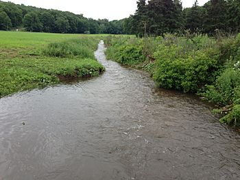
Coginchaug River facts for kids
Quick facts for kids Coginchaug River |
|
|---|---|

|
|
| Country | United States |
| State | Connecticut |
| Cities | Middletown, Middlefield, Durham, Guilford |
| Physical characteristics | |
| Main source | Guilford, Connecticut, New Haven County, Connecticut, United States 335 ft (102 m) 41°24′25″N 72°42′19″W / 41.40694°N 72.70528°W |
| River mouth | Mattabesset River Middletown, CT, Connecticut 20 ft (6.1 m) 41°34′42″N 72°39′30″W / 41.57833°N 72.65833°W |
| Length | 16.1 mi (25.9 km) |
| Basin features | |
| Basin size | 39 sq mi (100 km2) |
The Coginchaug River is a river in Connecticut, United States. It is an important waterway that flows into the Mattabesset River. The river is about 16.1 miles (25.9 km) long.
The Coginchaug River starts in Guilford, Connecticut. It then flows north through Durham, Connecticut and Middlefield, Connecticut. Finally, it reaches Middletown, Connecticut, where it joins the Mattabesset River. The Mattabesset River then flows into the larger Connecticut River.
The area around the river, called its watershed, covers 39 square miles (101 sq km). This area includes forests, farms, and some towns. The name "Coginchaug" comes from the local Native American people. It was the original name for the town of Durham. The name is thought to mean "The Great Swamp". This refers to the wide, flat meadows found in the middle part of the town.
Keeping the River Clean
The Coginchaug River is a natural treasure. However, like many rivers, it has faced challenges with pollution. In 2006, the river was noted for having some water quality issues. This was due to higher levels of certain natural substances.
Today, many groups are working to make the river cleaner. The Natural Resources Conservation Service is helping with these efforts. They are part of the United States Department of Agriculture. Their goal is to reduce pollution that enters the river. This includes pollution from farms and other sources. These efforts help protect the river for everyone.
Fun on the River: Canoeing
The Coginchaug River is a great place for outdoor adventures. Many people enjoy canoeing on its waters. In 2006, it was considered safe for canoeing. However, it is not recommended for activities like swimming.
The river starts slowly from Myer Huber Pond. It then flows through large swampy areas. These swamps can be tricky to paddle through. They are often best explored right after heavy rains. The main canoeing path begins at Route 147. From there, you can paddle downstream, heading north.
Along the way, you might need to carry your canoe around obstacles. These spots are called portages. There are several of these, including around six small dams. You will also find a portage at Wadsworth Falls. This is the only major waterfall on the river. Sometimes, the river can have exciting whitewater sections. These are rated as Class II on the International Scale of River Difficulty. Eventually, the river flows into the tidal marsh of the Mattabesset River.
 | Delilah Pierce |
 | Gordon Parks |
 | Augusta Savage |
 | Charles Ethan Porter |

