Durham (CDP), Connecticut facts for kids
Quick facts for kids
Durham, Connecticut
|
|
|---|---|

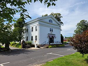
Town Hall
|
|
| Country | |
| State | Connecticut |
| County | Middlesex |
| Town | Durham |
| Area | |
| • Total | 21.37 km2 (8.25 sq mi) |
| • Land | 21.36 km2 (8.25 sq mi) |
| • Water | 0.01 km2 (0.004 sq mi) |
| Elevation | 73 m (239 ft) |
| Population
(2020)
|
|
| • Total | 3,771 |
| • Density | 176.5/km2 (457/sq mi) |
| Time zone | UTC-5 (Eastern (EST)) |
| • Summer (DST) | UTC-4 (EDT) |
| ZIP Code |
06422
|
| Area code(s) | 860/959 |
| FIPS code | 09-20740 |
| GNIS feature ID | 2377815 |
Durham is a special kind of community called a census-designated place (CDP). It includes the main village and the areas around it in the town of Durham. This town is located in Middlesex County, Connecticut, United States.
The CDP of Durham is found in the central and northeastern parts of the larger town of Durham. To its north, you'll find the town of Middlefield and the city of Middletown.
About Durham, Connecticut
Population and Size
In 2020, about 3,771 people lived in the Durham CDP. This was out of a total of 7,152 people in the entire town of Durham. A CDP is a place that looks like a town but isn't officially incorporated as one.
The Durham CDP covers an area of about 21.37 square kilometers (which is about 8.25 square miles). Most of this area is land, with only a tiny bit of water.
Historic Main Street
Durham has a special area called the Main Street Historic District. This district covers about 160 acres (or 0.65 square kilometers) right in the middle of the community. It's a place where many old and important buildings are preserved.
See also
 In Spanish: Durham (condado de Middlesex) para niños
 | Frances Mary Albrier |
 | Whitney Young |
 | Muhammad Ali |


