Saltonstall Mountain facts for kids
Quick facts for kids Saltonstall Mountain |
|
|---|---|

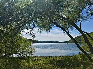
Looking south at two men fishing from a boat in Lake Saltonstall, Saltonstall Mountain is on the right.
|
|
| Highest point | |
| Elevation | est. 320 ft (98 m) ridge high point |
| Geography | |
| Location | Branford, North Branford, and East Haven, Connecticut |
| Parent range | Metacomet Ridge |
| Geology | |
| Age of rock | 200 Ma |
| Mountain type | Fault-block; igneous |
| Climbing | |
| Easiest route | Ridge Trail or Branford Trail |
Saltonstall Mountain, also called Saltonstall Ridge, is a cool mountain ridge made of a special rock called traprock. It stands about 320 feet (98 m) above sea level. This mountain is located about 3 miles (5 km) east of New Haven, Connecticut. It is also about 1.75 miles (2.8 km) north of Long Island Sound.
Saltonstall Mountain is part of a long chain of mountains called the Metacomet Ridge. This ridge stretches from Long Island Sound all the way north through Massachusetts to the Vermont border. The mountain is famous for its 100 foot (30 m) tall cliffs and sharp top. It also has special mini-ecosystems and rare plants. A big lake, Lake Saltonstall, is almost completely surrounded by the mountain. This lake is 3 miles (5 km) long and 0.3 miles (400 m) wide. You can explore Saltonstall Mountain on many hiking trails. These trails are looked after by the South Central Connecticut Regional Water Authority (SCCRWA) and the Branford Land Trust.
Contents
Where is Saltonstall Mountain Located?
Saltonstall Mountain rises steeply about 200 feet (61 m) from the land around it. Its highest point is about 320 feet (98 m) tall. The mountain is roughly 5.75 miles (9.3 km) long and 1.25 miles (2.0 km) wide. It looks a bit like a hunting bow.
This mountain is found within three towns: Branford, North Branford, and East Haven, Connecticut. The western side of the mountain is very steep. It has tall cliffs and slopes covered in loose rocks. The eastern side is lower and has more gentle hills.
Water Bodies Around the Mountain
The highest part of Saltonstall Mountain is at its northern end. Lake Saltonstall sits between the southern parts of the mountain. Besides Lake Saltonstall, other small ponds are found here. These include Lidyhites Pond, Linsley Pond, Cedar Pond, and the two Branford Supply Ponds. The Farm River flows along the western base of the mountain. Interstate 95, a major highway, cuts through the very southern tip of the ridge.
Neighboring Mountains and Rivers
The Metacomet Ridge continues north from Saltonstall Mountain as Totoket Mountain. To the south, it becomes Beacon Hill before ending at Long Island Sound. West of Saltonstall Mountain, the ridge continues through East Haven and New Haven. It forms several parallel traprock hills, ending with East Rock. Another nearby peak, Peter's Rock, is to the north-northwest.
Water flows off the west side of Saltonstall Mountain into the Farm River. This river then goes into the East Haven River and finally into Long Island Sound. Water from the east side flows into Pisgah Brook. This brook then joins the Branford River and also reaches Long Island Sound.
How Saltonstall Mountain Was Formed
Saltonstall Mountain is made of a type of rock called basalt. This rock is also known as traprock. It is a volcanic rock. The mountain formed about 200 million years ago. This was near the end of the Triassic Period. At that time, the huge continent of North America began to split away from Africa and Eurasia.
As the continents pulled apart, hot, melted rock called lava pushed up from deep inside the Earth. This lava spread out in thick layers. Over time, it cooled and hardened into the basalt rock we see today. Later, big movements in the Earth's crust caused faulting and earthquakes. These events tilted the rock layers. This tilting created the steep cliffs and sharp ridgeline of Saltonstall Mountain.
Special Ecosystems and Wildlife
The mountain has different types of environments, called microclimates. The upper slopes are hot and dry. The ravines are cool and moist. The ledges, made of basalt rock, are rich in minerals. This mix of conditions creates special places for plants and animals. Many species found here are rare in other parts of Connecticut.
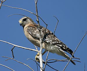
Some rare animals and plants protected by Connecticut that live on Saltonstall Mountain include the eastern box turtle and the red-shouldered hawk. You might also find the violet wood sorrel plant. Saltonstall Mountain is also an important path for raptors, which are birds of prey, as they migrate.
Protecting and Enjoying Saltonstall Mountain
The southern part of Saltonstall Mountain is a protected area. It is managed by the SCCRWA to protect the water supply. The SCCRWA has many hiking trails and paths for walking or biking on the ridge. They also have trails along the shore of Lake Saltonstall.
To visit this part of the mountain, you need a permit. This permit is good for a year and costs a small fee. You can get it from the SCCRWA. Once you have a permit, you can enjoy activities like hiking, bicycling, picnicking, and snowshoeing. There is a special nature trail and a ridgeline trail with amazing views.
Trails and Activities
The 28-mile (45 km) Branford Trail also passes through the eastern side of the SCCRWA land. This trail is a long path that loops around the town of Branford. It connects to many of the town's protected areas. You can also go fishing and boating on Lake Saltonstall. The SCCRWA has a boat rental shop and a fishing pier that is easy for everyone to use. You can only use the SCCRWA's boats on the lake. For safety, swimming and dogs are not allowed. Also, the southernmost 0.5 miles (800 m) of the mountain is closed to the public.
The northern part of the mountain is surrounded by neighborhoods. However, the Branford Land Trust and the town of Branford protect about 800 acres (3.2 km2) of open space on the northern summit and nearby areas. The Branford Trail also goes through these protected lands. Here, you can enjoy hiking and picnicking. The town of East Haven also has public access along the Farm River at the western base of Saltonstall Mountain, where fishing is allowed.
Where to Park for Trails
The SCCRWA parking lots are on Hoseley Avenue. They are about 1.9 miles (3.1 km) north of U.S. Route 1 in Branford. Remember, you need a permit to park here and use the trails or lake.
There are two parking areas for the Branford Trail. One is on Laurel Hill Road, which you reach from Brushy Hill Road. This is about 1.25 miles (2.0 km) north of its meeting with Route 1. The second is on Northford Avenue, from Mill Plain Road. This is about 1.2 miles (1.9 km) north of Route 1.
For the Branford Supply Ponds trails, there are three parking lots. They are on Chestnut Street and its extension, Short Rocks Road. These are 0.3 miles (0.5 km) north of Route 1. You do not need a permit to use the Branford Trail or Branford Supply Ponds parking areas.
 | Madam C. J. Walker |
 | Janet Emerson Bashen |
 | Annie Turnbo Malone |
 | Maggie L. Walker |


