Otis, Massachusetts facts for kids
Quick facts for kids
Otis
|
||
|---|---|---|

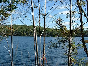
Benton Pond, East Otis
|
||
|
||

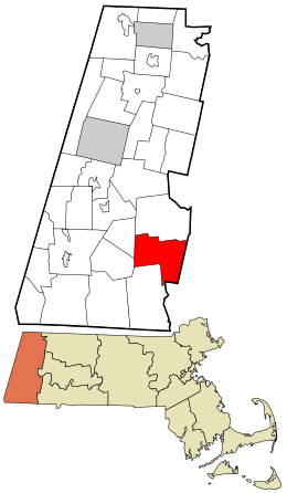
Location in Berkshire County and the state of Massachusetts.
|
||
| Country | United States | |
| State | Massachusetts | |
| County | Berkshire | |
| Settled | 1735 | |
| Incorporated (as Loudon) | 1810 | |
| Incorporated (as Otis) | June 13, 1810 | |
| Government | ||
| • Type | Open town meeting | |
| Area | ||
| • Total | 38.0 sq mi (98.5 km2) | |
| • Land | 35.6 sq mi (92.1 km2) | |
| • Water | 2.5 sq mi (6.5 km2) | |
| Elevation | 1,220 ft (372 m) | |
| Population
(2020)
|
||
| • Total | 1,634 | |
| • Density | 42.96/sq mi (16.589/km2) | |
| Time zone | UTC−5 (Eastern) | |
| • Summer (DST) | UTC−4 (Eastern) | |
| ZIP Code |
01253
|
|
| Area code(s) | 413 | |
| FIPS code | 25-51580 | |
| GNIS feature ID | 0619422 | |
Otis is a small town in Berkshire County, Massachusetts, in the United States. It is part of the larger Pittsfield area. In 2020, about 1,634 people lived here.
Contents
History of Otis
Otis became an official town in 1810. It was formed when two smaller areas, Loudon and Bethlehem, joined together. The town was named after Harrison Gray Otis. He was an important lawyer and politician during the time of the American Revolution.
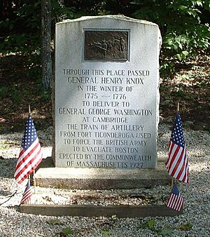
A famous event happened here in January 1776. Colonel Henry Knox traveled through the town. He was moving cannons from Fort Ticonderoga to help end the Siege of Boston. This route is now called the Knox Trail.
Long ago, Otis was mainly a farming community. There were also small mills along the rivers. Today, it is still mostly rural, but it also attracts tourists.
Geography of Otis

Otis covers about 98.5 square kilometers (38 square miles). Most of this area is land, with some water. The town is located on the eastern edge of Berkshire County. It borders several other towns like Becket, Blandford, and Sandisfield.
Otis is in the southern part of the Berkshire Mountains. You'll find several hills and marshy areas here. The West Branch of the Farmington River starts in Otis and flows south.
A large part of the southeastern town is covered by the Otis Reservoir and Big Pond. You can also find parts of Tolland State Forest and Otis State Forest. The highest points are Church Hill and Kingsbury Mountain in the north.
Otis is home to the Otis Ridge Ski Area, a place for winter sports. Most people live near the reservoir and the town center.
Traveling in Otis
Two main roads, Massachusetts Route 8 and Route 23, cross in Otis. Route 23 is also known as the Knox Trail. You can see a historical marker for it in the eastern part of town.
Interstate 90, also called the Massachusetts Turnpike, passes through the northern edge of Otis. The closest exit for this highway is in Lee. There are no train, bus, or air services directly in Otis. The nearest options are in Pittsfield and Westfield. For national flights, the closest airport is Bradley International Airport in Windsor Locks, Connecticut.
Climate in Otis
Otis experiences a typical New England climate. Temperatures often drop below 10 degrees Celsius (50 degrees Fahrenheit) for many days each year. The town gets about 48 inches of rain annually. Snow usually covers the ground for about 69 days each year.
| Climate data for West Otis, Massachusetts, 1981–2010 normals | |||||||||||||
|---|---|---|---|---|---|---|---|---|---|---|---|---|---|
| Month | Jan | Feb | Mar | Apr | May | Jun | Jul | Aug | Sep | Oct | Nov | Dec | Year |
| Mean daily maximum °F (°C) | 28.8 (−1.8) |
32.7 (0.4) |
40.9 (4.9) |
54.3 (12.4) |
66.3 (19.1) |
72.9 (22.7) |
77.8 (25.4) |
76.0 (24.4) |
68.5 (20.3) |
57.2 (14.0) |
46.3 (7.9) |
33.8 (1.0) |
54.6 (12.6) |
| Daily mean °F (°C) | 19.8 (−6.8) |
22.9 (−5.1) |
31.2 (−0.4) |
43.0 (6.1) |
54.3 (12.4) |
62.4 (16.9) |
67.1 (19.5) |
65.6 (18.7) |
58.0 (14.4) |
46.9 (8.3) |
37.2 (2.9) |
25.7 (−3.5) |
44.5 (7.0) |
| Mean daily minimum °F (°C) | 10.9 (−11.7) |
13.0 (−10.6) |
21.4 (−5.9) |
31.7 (−0.2) |
42.2 (5.7) |
51.8 (11.0) |
56.4 (13.6) |
55.2 (12.9) |
47.5 (8.6) |
36.6 (2.6) |
28.1 (−2.2) |
17.6 (−8.0) |
34.4 (1.3) |
| Average precipitation inches (mm) | 3.33 (85) |
3.16 (80) |
3.88 (99) |
3.96 (101) |
4.08 (104) |
4.49 (114) |
4.02 (102) |
4.08 (104) |
4.13 (105) |
4.67 (119) |
4.18 (106) |
3.72 (94) |
47.70 (1,212) |
| Average snowfall inches (cm) | 16.1 (41) |
11.4 (29) |
8.3 (21) |
2.1 (5.3) |
0.0 (0.0) |
0.0 (0.0) |
0.0 (0.0) |
0.0 (0.0) |
0.0 (0.0) |
0.5 (1.3) |
3.5 (8.9) |
11.7 (30) |
53.6 (136.5) |
| Average precipitation days (≥ 0.01 in) | 11.3 | 10.5 | 11.1 | 11.3 | 12.7 | 12.0 | 10.3 | 10.1 | 8.9 | 9.8 | 10.8 | 11.9 | 130.7 |
| Average snowy days (≥ 0.1 in) | 6.7 | 6.3 | 4.5 | 1.3 | 0.0 | 0.0 | 0.0 | 0.0 | 0.0 | 0.1 | 1.3 | 5.5 | 25.7 |
| Source: NOAA | |||||||||||||
People in Otis
| Historical population | ||
|---|---|---|
| Year | Pop. | ±% |
| 1850 | 1,224 | — |
| 1860 | 998 | −18.5% |
| 1870 | 960 | −3.8% |
| 1880 | 785 | −18.2% |
| 1890 | 583 | −25.7% |
| 1900 | 476 | −18.4% |
| 1910 | 494 | +3.8% |
| 1920 | 361 | −26.9% |
| 1930 | 367 | +1.7% |
| 1940 | 364 | −0.8% |
| 1950 | 359 | −1.4% |
| 1960 | 473 | +31.8% |
| 1970 | 820 | +73.4% |
| 1980 | 963 | +17.4% |
| 1990 | 1,073 | +11.4% |
| 2000 | 1,365 | +27.2% |
| 2010 | 1,612 | +18.1% |
| 2020 | 1,634 | +1.4% |
| 2022* | 1,626 | −0.5% |
| * = population estimate. Source: United States Census records and Population Estimates Program data. |
||
According to the 2000 census, 1,365 people lived in Otis. This makes it one of the smaller towns in Berkshire County. Most of the people living in Otis are White (96.56%).
There were 567 households in the town. About 26.6% of these households had children under 18. Many households (59.1%) were married couples living together. About 24.3% of households were individuals living alone.
The population of Otis is spread out by age. About 21.8% of residents were under 18. About 30.3% were between 45 and 64 years old. The average age in Otis was 42 years.
Education in Otis
Otis is part of the Farmington River Regional School District. This district also includes the nearby towns of Sandisfield, Tolland, and Becket.
The only school in the district is Farmington River Elementary School. It teaches students from pre-kindergarten up to sixth grade. After sixth grade, most students go to middle and high schools in Great Barrington or Lee.
There are also private schools in nearby towns like Lenox and Great Barrington. For higher education, the closest community college is Berkshire Community College. The nearest state university is Westfield State University.
See also
 In Spanish: Otis (Massachusetts) para niños
 | Calvin Brent |
 | Walter T. Bailey |
 | Martha Cassell Thompson |
 | Alberta Jeannette Cassell |


