West Springfield, Massachusetts facts for kids
Quick facts for kids
West Springfield, Massachusetts
|
|||
|---|---|---|---|
| Town of West Springfield[*] | |||
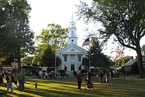
Storrowton Green
at the Eastern States Exposition |
|||
|
|||
| Nickname(s):
West Side,
"Crossroads of New England" |
|||
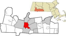
Location in Hampden County in Massachusetts
|
|||
| Country | United States | ||
| State | Massachusetts | ||
| County | Hampden | ||
| Settled | 1655 | ||
| Incorporated (town) | 1774 | ||
| Incorporated (city) | 2000 | ||
| Government | |||
| • Type | Mayor-council city | ||
| Area | |||
| • Total | 17.54 sq mi (45.42 km2) | ||
| • Land | 16.73 sq mi (43.33 km2) | ||
| • Water | 0.81 sq mi (2.09 km2) | ||
| Elevation | 65 ft (20 m) | ||
| Population
(2020)
|
|||
| • Total | 28,835 | ||
| • Density | 1,723.55/sq mi (665.45/km2) | ||
| Time zone | UTC−5 (Eastern) | ||
| • Summer (DST) | UTC−4 (Eastern) | ||
| ZIP code |
01089
|
||
| Area code(s) | 413 | ||
| FIPS code | 25-77850 | ||
| GNIS feature ID | 0618194 | ||
West Springfield is a city in Hampden County, Massachusetts, United States. It is part of the larger Springfield, Massachusetts area. In 2020, about 28,835 people lived here. People often call it "West Side" because it's on the western side of the Connecticut River, across from the city of Springfield. This location was very important in the city's early days.
Contents
- Discovering West Springfield's Past
- How West Springfield Began
- Becoming More Independent
- Breaking Away from Springfield
- West Springfield During the American Revolution
- Building Bridges Across the River
- Facing Natural Disasters
- Farming and Fairs
- Railroads and Industry
- How Holyoke and Agawam Became Separate Towns
- Highway Construction and Changes
- West Springfield's Location and Features
- Neighborhoods of West Springfield
- Getting Around West Springfield
- Education in West Springfield
- What is West Springfield's Economy Like?
- Fun Places to Visit
- Media and Pop Culture
- Sports in West Springfield
- Famous People from West Springfield
- See also
Discovering West Springfield's Past
How West Springfield Began
The area that is now West Springfield was first settled in 1635. After a big hurricane that year, many settlers moved to higher ground on the east side of the river and started Springfield. However, the land on the west side was great for farming, so some families decided to stay there.
Early Challenges for Settlers
In the early days, people mostly farmed and raised animals. They traded crops and goods with their neighbors. Crossing the wide Connecticut River was a big problem because there were no bridges. People had to use boats. A special area called the "Hay Place" was set up for farmers to leave their crops while waiting for transport across the river.
By the 1650s, some English settlers began living on the west side of the river all year round. These residents often complained about having to work on roads on the east side of the river, while their own roads were not well maintained. After some disagreements, it was decided that people would take care of the roads on their own side of the river.
Becoming More Independent
In early New England, church and government were closely linked. Everyone had to attend town meetings and church services. West Side residents asked for a free ferry to get to the church in Springfield, but they were refused. In 1683, a family drowned while trying to cross the river for church. This sad event made west side residents demand their own church. In 1697, they finally got approval for a separate church and meeting house.
Later, in 1706, west side residents also got money to build their own school. This showed they were becoming more independent from Springfield.
Breaking Away from Springfield
Because it was still hard to cross the river for town meetings, and there were disagreements over resources, the west side residents asked to become their own town in 1756. After many arguments, West Springfield officially became a separate town on February 23, 1774. At that time, it included areas that are now Agawam and most of Holyoke.
West Springfield During the American Revolution
West Springfield's local soldiers, called minutemen, joined the American Revolutionary War right after the first battles in April 1775. Later, in 1777, some German and British soldiers captured during the war stayed in West Springfield and married local people.
After the war, tough economic times led to a protest known as Shays' Rebellion in 1786–1787, which involved people from Springfield and West Springfield.
Building Bridges Across the River
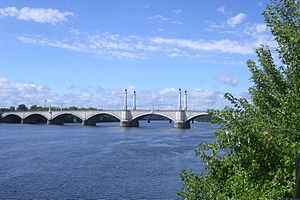
The first bridge across the Connecticut River was built in 1805. It was a toll bridge, meaning people had to pay to cross. This bridge was damaged by floods and later collapsed. A replacement bridge opened in 1816, but it was also destroyed by ice. A third bridge, built on the same foundations, lasted for over 100 years.
The modern Memorial Bridge opened in 1922. Another important bridge, the North End Bridge, opened in 1887. It burned down in 1923, and a new one was built in its place, which is still used today. Many bridges were also built over the Westfield River, but floods often destroyed them.
Facing Natural Disasters
West Springfield has experienced many floods throughout its history. Major floods occurred in 1936, displacing 8,000 people, and in 1955, when two hurricanes hit five days apart. These floods damaged the town's water supply and other facilities.
Winter storms have also caused problems. The Great Blizzard of 1888 brought over 5 feet (1.5 meters) of snow. More recent blizzards hit in 1978 and 1996.
On June 1, 2011, a powerful tornado touched down in West Springfield. It caused significant damage to many homes and buildings. The President of the United States declared the area a federal disaster area. Later that year, in October 2011, a heavy snowstorm caused trees and branches to fall, leading to power outages for over a week.
Farming and Fairs
Farming was very important to West Springfield's economy for a long time. By the 1830s, farmers started growing crops to sell for cash, not just for their own families. They even used greenhouses and sent fresh crops to Boston. Over time, as the town grew and the economy changed, farming became less common.
The Eastern States Exposition, also known as "The Big E," started in 1917. It's an annual fall fair that is West Springfield's biggest tourist attraction and one of the largest fairs in the country. The exposition grounds host many events all year long.
Railroads and Industry
In the 1800s, small factories began to appear, making things like leather, carriages, and paper. The paper industry became very important in the area, with several paper mills opening in West Springfield.
The Western Railroad opened in 1841, connecting West Springfield to other cities. This made West Springfield a major transportation hub. The railroad became one of the biggest employers in town for many years. Repair shops were built, and there were two large rail yards.
Horse-drawn trolleys started running in 1877, connecting West Springfield to Springfield. These trolleys later became electric. Over the years, the trolley lines expanded, but passenger service ended by 1936. Today, buses and trains like Amtrak provide public transportation.
As cars became more popular, the railroad repair shop closed in 1956, and the passenger station closed in 1957. However, the central rail yard is still used for freight trains.
How Holyoke and Agawam Became Separate Towns
The "North Parish" of West Springfield, which was good for building canals and mills, became the independent town of Holyoke in 1850. The area south of the Westfield River, including Agawam and Feeding Hills, became the independent town of Agawam in 1855.
Highway Construction and Changes
Major highways were built through and around West Springfield in the mid-1900s. U.S. Route 5 (Riverdale Street) was changed to bypass downtown areas, which helped speed up travel. The Massachusetts Turnpike (I-90) was built from 1955 to 1957.
Interstate 91 was built between 1958 and 1970. Originally, it was planned to go through West Springfield. This would have helped local businesses. However, Springfield city planners argued for the highway to go through Springfield instead. They believed it would bring economic growth to their city.
In the end, I-91 was built on the Springfield side of the river. This meant West Springfield didn't get the economic boost it might have from the highway traffic.
West Springfield's Location and Features
West Springfield covers about 17.5 square miles (45.4 square kilometers). Most of this is land, with a small amount of water. It sits on the west side of the Connecticut River and the north side of the Westfield River.
To the west, West Springfield has cliffs called East Mountain. These are part of the Metacomet Ridge, a long line of mountains. A hiking trail, the Metacomet-Monadnock Trail, runs through these mountains.
West Springfield is about 27 miles (43 km) from Hartford, Connecticut, and 90 miles (145 km) from Boston. It's also only 6 miles (10 km) from Six Flags New England, a popular amusement park.
Other important natural spots include:
- Bagg Brook and Block Brook
- Bear Hole – a large wooded area with a reservoir. It's a great place for hiking and seeing wildlife like owls and deer.
- Mittineague Park
- Pawcatuck Brook
- Town Common – a tree-lined park used for public gatherings.
- White Church Hill – home to one of the town's main churches.
Neighborhoods of West Springfield
West Springfield has several unique neighborhoods:
- Amostown - Named after an early settler.
- Ashleyville - Located near Interstate 91.
- Cayenne - Named in a playful way by a resident.
- Downtown West Springfield - The main area with shops and offices.
- Memorial - Close to Memorial Avenue and The Big E.
- Merrick - Named after a family who owned a lot of land.
- Mittineague - An old Native American name, located by the Westfield River.
- Tatham - Another Native American name, located northwest of Mittineague.
Getting Around West Springfield
Roads
Several main roads pass through West Springfield, making it easy to get around:
- Interstate 91
- Massachusetts Turnpike (I-90)
- U.S. Route 5 (Riverdale Street)
- U.S. Route 20 (Westfield Street)
- Massachusetts Route 147 (Memorial Avenue)
Public Transportation
West Springfield is served by the Pioneer Valley Transit Authority bus system, which connects the city to Springfield and other nearby towns. You can also catch Amtrak trains from Springfield.
Education in West Springfield
The West Springfield Public Schools district runs nine schools. The town also has a charter school, a Catholic school, and two schools for special education. The public school sports teams are called the "Terriers."
Public Schools
- Cowing School (preschool and special programs)
- John Ashley School (Pre-Kindergarten to Kindergarten)
- Phillip G. Coburn Elementary (Kindergarten to Grade 5)
- John R. Fausey Elementary (Grades 1-5)
- Memorial Elementary (Grades 1-5)
- Mittineague Elementary (Grades 1-5)
- Tatham Elementary (Kindergarten to Grade 5)
- West Springfield Middle School (Grades 6-8)
- West Springfield High School (Grades 9-12)
Other Schools
- Lower Pioneer Valley Educational Collaborative (for special education)
- St. Thomas the Apostle (Kindergarten to Grade 8, a Catholic school)
- Hampden Charter School of Science West (Grades 6-11)
- May Center School for Autism and Developmental Disabilities (a private school)
What is West Springfield's Economy Like?
West Springfield is known as the "crossroads of New England" because it has easy access to major highways and railroads. This makes it a good place for businesses.
The Riverdale Road area is a big shopping center with many large stores and car dealerships. The Eastern States Exposition (The Big E) is also a major employer, especially during its annual fair.
Fun Places to Visit
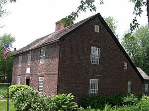
- The Josiah Day House: This historic house, built around 1754, is believed to be the oldest brick saltbox-style house in the United States.
- The Eastern States Exposition (the "Big E"): A huge annual fair that attracts many visitors.
- The Metacomet-Monadnock Trail: A long hiking trail that goes through the western part of West Springfield.
The city also has several parks for outdoor activities:
- Mittineague Park
- Veterans Field (for football and baseball)
- Cook's Park
- Town Common
- Ohio Field
- Old Tatham Field
- New Tatham Field
- Clark Field
Media and Pop Culture
West Springfield has one local newspaper, the West Springfield Record, which comes out every Thursday. Other news comes from regional papers like The Republican from Springfield.
Did you know that West Springfield is one of two cities that helped inspire the fictional town of Springfield in The Simpsons? Also, the TV show Complete Savages (2004–2005) was set in West Springfield.
Sports in West Springfield
West Springfield was once home to the Springfield Indians hockey team from 1926 to 1972. They played at the Eastern States Coliseum. The Massachusetts Twisters, an indoor soccer team, also played there.
Famous People from West Springfield
Many notable people have connections to West Springfield:
- Angelo Bertelli: A football player who won the Heisman Trophy for Notre Dame.
- Amo Bessone: A famous hockey coach and Hall of Fame inductee.
- Peter Bessone: Also a United States Hockey Hall of Fame inductee.
- Chris Capuano: A Major League Baseball pitcher.
- Tim Daggett: An Olympic gold medalist in gymnastics.
- Harry Dalton: A general manager in Major League Baseball.
- Luke Day: A captain in the Revolutionary War and a leader in Shays' Rebellion.
- Leo Durocher: A Baseball Hall of Fame player and manager.
- Eugene Grazia: A member of the 1960 U.S. Olympic gold medal hockey team.
- Horace A. Moses: A local philanthropist who founded the Strathmore Paper Company.
- Joe Ragland: A professional basketball player.
- Vic Raschi: A Major League Baseball pitcher who won six World Series.
- Brian Scully: A television writer and producer for The Simpsons and Family Guy.
- Mike Scully: A former co-producer of The Simpsons.
- Stass Shpanin: A visual artist listed in the Guinness Book of World Records as the Youngest Professional.
See also
 In Spanish: West Springfield (Massachusetts) para niños
 | Victor J. Glover |
 | Yvonne Cagle |
 | Jeanette Epps |
 | Bernard A. Harris Jr. |


