Montgomery, Massachusetts facts for kids
Quick facts for kids
Montgomery, Massachusetts
|
|||
|---|---|---|---|

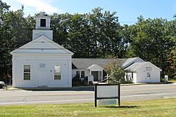
Montgomery Town Offices
|
|||
|
|||

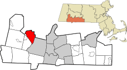
Location in Hampden County in Massachusetts
|
|||
| Country | United States | ||
| State | Massachusetts | ||
| County | Hampden | ||
| Settled | 1767 | ||
| Incorporated | 1780 | ||
| Government | |||
| • Type | Open town meeting | ||
| Area | |||
| • Total | 15.2 sq mi (39.3 km2) | ||
| • Land | 15.1 sq mi (39.0 km2) | ||
| • Water | 0.1 sq mi (0.3 km2) | ||
| Elevation | 1,049 ft (320 m) | ||
| Population
(2020)
|
|||
| • Total | 819 | ||
| • Density | 53.88/sq mi (20.84/km2) | ||
| Time zone | UTC-5 (Eastern) | ||
| • Summer (DST) | UTC-4 (Eastern) | ||
| ZIP code |
01085
|
||
| Area code(s) | 413 | ||
| FIPS code | 25-42530 | ||
| GNIS feature ID | 0618189 | ||
Montgomery is a small town located in Hampden County, Massachusetts, United States. It's a quiet place with a population of 819 people, according to the 2020 census. Montgomery is part of the larger Springfield area.
History of Montgomery
When Was Montgomery Settled?
Montgomery was first settled by people in 1767. It officially became a town in 1780, right in the middle of the American Revolutionary War.
Who Was Montgomery Named After?
The town got its name from General Richard Montgomery. He was an important general who fought and died in the Battle of Quebec. This battle was part of an American effort to capture Quebec City during the Revolutionary War.
How Did Montgomery Grow?
Originally, Montgomery was a farming community with a small town center. Its population started to grow more quickly after Interstate 90, a major highway, was built in 1957. Today, many people who live in Montgomery travel to work in nearby Springfield.
Geography and Nature
Where is Montgomery Located?
Montgomery is located in western Massachusetts. It covers about 15.2 square miles (39.3 square kilometers) of land and a small amount of water. The town is surrounded by other towns: Southampton to the northeast, Westfield to the southeast, Russell to the southwest, and Huntington to the northwest.
Montgomery is about 17 miles (27 km) west of Springfield. It's also about 101 miles (163 km) west of Boston, the capital of Massachusetts. Interestingly, Montgomery is closer to the capitals of two other states, Hartford, Connecticut, and Albany, New York, than it is to Boston!
Mountains and Rivers in Montgomery
The town sits on a high flat area, or plain. It has mountains nearby like Lizzie Mountain to the northeast and Tekoa and Shatterack Mountains to the south and west. The Westfield River flows along some of the town's border with Russell. Inside Montgomery, you'll find Moose Meadow Brook and two reservoirs: the Westfield Reservoir and the smaller Tekoa Reservoir.
Transportation in Montgomery
There aren't many major roads that go through Montgomery. A very short part of Interstate 90 (less than 200 yards) crosses the southern tip of the town. There are only nine roads that enter or leave the town, and some of them are dead ends.
Railroad tracks run along the Westfield River. These tracks are used by CSX and Amtrak trains traveling between Springfield and Pittsfield. There is no public transportation like buses within the town itself. For air travel, the closest small airport is Barnes Municipal Airport in Westfield. For bigger flights, you'd go to Bradley International Airport in Connecticut or Logan International Airport in Boston.
Population and People
How Many People Live in Montgomery?
As of the 2000 census, there were 654 people living in Montgomery. The town had 253 households, with most of them being families. The population density was about 43 people per square mile (17 people per square kilometer).
What is the Age Range in Montgomery?
The people in Montgomery are of all ages. About 22.9% of the population was under 18 years old. About 10.7% were 65 years old or older. The average age in town was 42 years. For every 100 females, there were about 104 males.
Income in Montgomery
In 2000, the average income for a household in Montgomery was $59,063. For families, the average income was $66,250.
Zip Codes for Montgomery
Montgomery does not have its own unique zip code. Residents use zip codes from nearby towns, either Huntington (01050) or Westfield (01085).
See also
 In Spanish: Montgomery (Massachusetts) para niños
 | DeHart Hubbard |
 | Wilma Rudolph |
 | Jesse Owens |
 | Jackie Joyner-Kersee |
 | Major Taylor |


