Conway, Massachusetts facts for kids
Quick facts for kids
Conway, Massachusetts
|
||
|---|---|---|
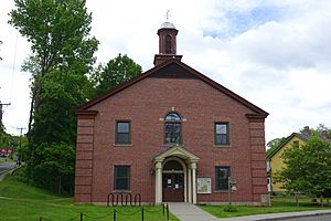
Conway Town Hall
|
||
|
||
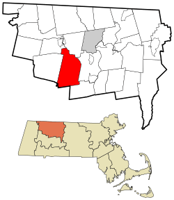
Location in Franklin County in Massachusetts
|
||
| Country | United States | |
| State | Massachusetts | |
| County | Franklin | |
| Settled | 1762 | |
| Incorporated | 1767 | |
| Government | ||
| • Type | Open town meeting | |
| Area | ||
| • Total | 37.9 sq mi (98.1 km2) | |
| • Land | 37.7 sq mi (97.6 km2) | |
| • Water | 0.2 sq mi (0.5 km2) | |
| Elevation | 673 ft (205 m) | |
| Population
(2020)
|
||
| • Total | 1,761 | |
| • Density | 46.49/sq mi (17.951/km2) | |
| Time zone | UTC−5 (Eastern) | |
| • Summer (DST) | UTC−4 (Eastern) | |
| ZIP Code |
01341
|
|
| Area code(s) | 413 | |
| FIPS code | 25-15200 | |
| GNIS feature ID | 0618161 | |
Conway is a small town located in Franklin County, Massachusetts, in the United States. In 2020, about 1,761 people lived here. It is part of the larger Springfield area.
Contents
History of Conway
Early Settlement and Naming
English settlers first came to the area that is now Conway in 1762. At that time, it was the southwestern part of the town of Deerfield. Conway officially became its own town in 1767.
The town was named after General Henry Seymour Conway. He was an important leader in the British government. He helped to get rid of the Stamp Act, which was a tax that angered the American colonists. Other towns, like Conway, New Hampshire, were also named after him.
Farming and Industry
In its early years, Conway was known for farming, especially raising sheep. There were also some small factories along the South River. However, a dam broke in 1869, and this washed away much of the industry. Today, Conway is still mostly a farming community.
Historic Landmarks
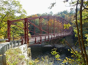
The Bardwell's Ferry Bridge was built in 1882. It is a special type of bridge called a lenticular truss bridge. It crosses the Deerfield River between Conway and Shelburne. This historic bridge is now listed on the National Register of Historic Places.
The town's Field Memorial Library was a gift from Marshall Field. He was a famous businessman who grew up in Conway. The library was designed by well-known architects and finished in 1901.
Recent Events
On February 25, 2017, an EF1 tornado touched down in Conway. This tornado caused a lot of damage in some areas. It was the first tornado ever recorded in Massachusetts during the month of February.
Geography of Conway
Conway covers about 98.1 square kilometers (37.9 square miles). Most of this area, about 97.6 square kilometers (37.7 square miles), is land. Only a small part, 0.5 square kilometers (0.2 square miles), is water.
Location and Borders
Conway is in the middle of Franklin County. It shares borders with several other towns:
- Shelburne to the north
- Deerfield to the east
- Whately to the southeast
- Williamsburg to the south
- Goshen to the southwest
- Ashfield to the west
- Buckland to the northwest
Historic areas like Burkville and Shirkshire are also part of Conway. The town is about 16 kilometers (10 miles) southwest of Greenfield. It is also about 51 kilometers (32 miles) north-northwest of Springfield. Boston is about 159 kilometers (99 miles) to the west-northwest.
Rivers and Forests
The Deerfield River forms most of Conway's northern border. The Bardwell's Ferry Bridge helps people cross this river to Shelburne. The South River also flows through Conway, from Ashfield to the Deerfield River. Many smaller streams feed into these rivers.
Conway has many forests and hills. It is home to several state forests, including Conway State Forest and South River State Forest. There is also the Poland Brook State Wildlife Management Area.
Transportation
Massachusetts Route 116 goes through the center of Conway. It connects Ashfield to Deerfield and continues towards Springfield. The closest major highway, Interstate 91, has exits in nearby Deerfield.
A freight train track runs through the northern part of town, next to the Deerfield River. The nearest train station for passengers is in Greenfield. Bus services are available in Deerfield. For air travel, a small airport is in Turners Falls. The closest major airport is Bradley International Airport in Windsor Locks, Connecticut.
Population Information
| Historical population | ||
|---|---|---|
| Year | Pop. | ±% |
| 1776 | 905 | — |
| 1840 | 1,394 | +54.0% |
| 1850 | 1,831 | +31.3% |
| 1860 | 1,689 | −7.8% |
| 1870 | 1,460 | −13.6% |
| 1880 | 1,760 | +20.5% |
| 1890 | 1,451 | −17.6% |
| 1900 | 1,458 | +0.5% |
| 1910 | 1,230 | −15.6% |
| 1920 | 961 | −21.9% |
| 1930 | 900 | −6.3% |
| 1940 | 944 | +4.9% |
| 1950 | 873 | −7.5% |
| 1960 | 875 | +0.2% |
| 1970 | 998 | +14.1% |
| 1980 | 1,213 | +21.5% |
| 1990 | 1,529 | +26.1% |
| 2000 | 1,809 | +18.3% |
| 2010 | 1,897 | +4.9% |
| 2020 | 1,761 | −7.2% |
| 2022 | 1,760 | −0.1% |
Source: United States Census records and Population Estimates Program data. |
||
In 2000, Conway had 1,809 people living in 692 households. Most people in Conway were White. A small percentage were from other racial backgrounds or were Hispanic/Latino.
The average household had about 2.61 people. The average family had about 3.01 people. The median age in town was 40 years old.
Education in Conway
Conway is part of the Frontier Regional and Union 38 School Districts. These districts also include the towns of Deerfield, Whately, and Sunderland.
Local Schools
Each town in the district has its own elementary school. In Conway, students from kindergarten through sixth grade attend Conway Grammar School. After sixth grade, all students from these four towns go to Frontier Regional High School in Deerfield.
There are also some private and charter schools in the nearby Greenfield and Deerfield areas. One example is the Deerfield Academy.
Higher Education
For students interested in college, Greenfield Community College is located in Greenfield. State colleges like Massachusetts College of Liberal Arts and state universities like the University of Massachusetts Amherst are also nearby. Many private colleges are located southeast in the Northampton area.
Notable People from Conway
Many interesting people have connections to Conway:
- Brian Bram – an illustrator known for his work on American Splendor
- Jack Chesbro – a famous baseball pitcher who is in the Hall of Fame; he retired and passed away in Conway
- John Crowley – an author
- Marshall Field – the founder of the famous department store Marshall Field and Company
- Moses Hayden – a former US Congressman
- Holly Hobbie – an author of children's books
- Archibald MacLeish – a poet who won a Pulitzer Prize and was the Librarian of Congress
- Erin McKeown – a singer-songwriter
- Socrates Nelson – a Minnesota State Senator
- Hortense May Orcutt – an educator
- William Collins Whitney – a financier and Secretary of the Navy
- Austin Eli Wing – a politician from Michigan
See also
 In Spanish: Conway (Massachusetts) para niños
 | James Van Der Zee |
 | Alma Thomas |
 | Ellis Wilson |
 | Margaret Taylor-Burroughs |


