
Monroe, Massachusetts facts for kids
Quick facts for kids
Monroe, Massachusetts
|
||
|---|---|---|

Monroe Town Hall as seen from Depot Street
|
||
|
||

Location in Franklin County in Massachusetts
|
||
| Country | United States | |
| State | Massachusetts | |
| County | Franklin | |
| Settled | 1800 | |
| Incorporated | 1822 | |
| Government | ||
| • Type | Open town meeting | |
| Area | ||
| • Total | 10.8 sq mi (27.9 km2) | |
| • Land | 10.7 sq mi (27.7 km2) | |
| • Water | 0.08 sq mi (0.2 km2) | |
| Elevation | 1,903 ft (580 m) | |
| Population
(2020)
|
||
| • Total | 118 | |
| • Density | 10.95/sq mi (4.229/km2) | |
| Time zone | UTC-5 (Eastern) | |
| • Summer (DST) | UTC-4 (Eastern) | |
| ZIP code |
01350
|
|
| Area code(s) | 413 | |
| FIPS code | 25-42040 | |
| GNIS feature ID | 0618170 | |
| Website | n/a | |

Monroe is a small town in Franklin County, Massachusetts, United States. In 2020, only 118 people lived there. This makes Monroe the smallest town in Franklin County by size, population, and how many people live per square mile. It is also the second-smallest town by population in all of Massachusetts. Monroe is the smallest town on the mainland of Massachusetts. Only Gosnold, Massachusetts, an island town, has fewer people.
Monroe is part of the larger Springfield area.
Contents
History of Monroe
Monroe was first settled in the year 1800. It officially became a town in 1822. The town was named after James Monroe, who was the President of the United States at that time.
In its early days, Monroe was mostly a farming community. Many people worked in dairy farming. In the mid-1800s, the town saw some activity from the building of the Hoosac Tunnel. This long railroad tunnel was built just south of Monroe in Florida.
Later, in 1885, a new railroad line was built. It connected nearby Readsboro, Vermont, to Holyoke, Massachusetts. This line was used to carry wood pulp to a paper factory. Because of this, the Ramage family decided to open their own paper company in Monroe in 1887. The James Ramage Paper Company became the town's main business for many years. It finally closed in 1984.
Geography and Location
Monroe covers about 10.8 square miles (27.9 square kilometers). Most of this area is land, with a small amount of water. The town is located in the northwestern part of Franklin County. It sits right on the border with Vermont. To the west, it borders Berkshire County. To the north, it borders Bennington County, Vermont.
Monroe is surrounded by other towns. To the north are Stamford, Vermont and Readsboro, Vermont. To the east is Rowe, Massachusetts. To the south and west is Florida, Massachusetts. Monroe is about 26 miles (42 km) northwest of Greenfield, Massachusetts. It is also about 115 miles (185 km) west-northwest of Boston, Massachusetts.
Natural Features of Monroe
Monroe is located on the Hoosac Range. This is the northern part of The Berkshires, a beautiful mountain range. The eastern edge of Monroe runs along the Deerfield River. This river flows south and east towards the Connecticut River. Part of the Deerfield River in Monroe is dammed. This creates the southern end of the Sherman Reservoir. This reservoir used to provide power to a nuclear power plant called Yankee Rowe. Several small streams also flow through the town. A large part of central and southern Monroe is covered by the Monroe State Forest. This forest also extends into the neighboring town of Florida.
Road Access and Monroe Bridge
Monroe is quite isolated when it comes to roads. There are no major highways or state routes that go directly into the town. The closest state route is Massachusetts Route 2. The nearest major highway is Interstate 91.
The neighborhood of Monroe Bridge is in the eastern part of town. It is near the border with Rowe. Monroe Bridge and Rowe meet along the Deerfield River. Monroe Bridge is the most developed area of the town. It has several homes and the Monroe Town Hall. These buildings are mostly centered around Depot Street.
Population and People
| Historical population | ||
|---|---|---|
| Year | Pop. | ±% |
| 1840 | 260 | — |
| 1850 | 254 | −2.3% |
| 1860 | 236 | −7.1% |
| 1870 | 201 | −14.8% |
| 1880 | 166 | −17.4% |
| 1890 | 282 | +69.9% |
| 1900 | 305 | +8.2% |
| 1910 | 246 | −19.3% |
| 1920 | 173 | −29.7% |
| 1930 | 218 | +26.0% |
| 1940 | 207 | −5.0% |
| 1950 | 174 | −15.9% |
| 1960 | 210 | +20.7% |
| 1970 | 216 | +2.9% |
| 1980 | 179 | −17.1% |
| 1990 | 115 | −35.8% |
| 2000 | 93 | −19.1% |
| 2010 | 121 | +30.1% |
| 2020 | 118 | −2.5% |
| 2022 | 115 | −2.5% |
Source: United States Census records and Population Estimates Program data. |
||
Monroe is the smallest town in Franklin County by population. It is also the second smallest in all of Massachusetts. In the year 2000, there were 93 people living in Monroe. There were 43 households, which are groups of people living together. Of these, 23 were families. The town's population density was about 8.7 people per square mile. This means not many people live close together. All of the people living in Monroe at that time were White.
About 24.7% of the people were under 18 years old. About 17.2% were 65 years or older. The average age in Monroe was 41 years old. For every 100 females, there were about 86 males.
The average income for a household in Monroe was $25,500 in 2000. The average income for a family was $21,250. Monroe has the lowest average income per person of any town in Massachusetts.
Education in Monroe
Monroe does not have its own schools. Students from Monroe attend schools in nearby towns.
- Elementary and Middle School: Children from pre-kindergarten to eighth grade go to the Abbott Memorial School in Florida.
- High School: For ninth through twelfth grades, students attend Drury High School in North Adams.
- Other Options: Students can also choose to go to C.H. McCann Technical School for high school. There are also private and religious schools in the North Adams area for all grades.
Colleges Near Monroe
For higher education, there are several options nearby:
- The closest community college is Greenfield Community College in Greenfield.
- The nearest state college is Massachusetts College of Liberal Arts in North Adams.
- The closest state university is the University of Massachusetts Amherst.
- A nearby private college is Williams College in Williamstown.
Images for kids
-
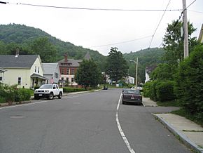
On Depot St. looking west towards town hall
-
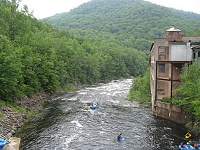
Monroe on the right (west) bank, Rowe on the left (east) bank
-
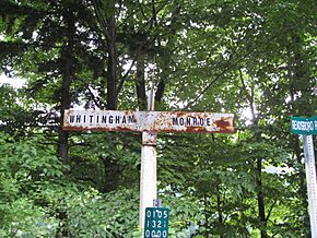
At the state line
-
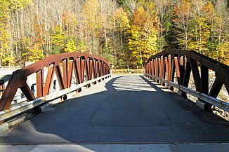
Monroe Bridge


See also
 In Spanish: Monroe (Massachusetts) para niños
