Cummington, Massachusetts facts for kids
Quick facts for kids
Cummington, Massachusetts
|
|||
|---|---|---|---|

William Cullen Bryant Homestead
|
|||
|
|||

Location in Hampshire County in Massachusetts
|
|||
| Country | United States | ||
| State | Massachusetts | ||
| County | Hampshire | ||
| Settled | 1762 | ||
| Incorporated | 1779 | ||
| Government | |||
| • Type | Open town meeting | ||
| Area | |||
| • Total | 23.1 sq mi (59.7 km2) | ||
| • Land | 22.9 sq mi (59.3 km2) | ||
| • Water | 0.1 sq mi (0.3 km2) | ||
| Elevation | 1,519 ft (463 m) | ||
| Population
(2020)
|
|||
| • Total | 829 | ||
| • Density | 35.96/sq mi (13.886/km2) | ||
| Time zone | UTC−5 (Eastern) | ||
| • Summer (DST) | UTC−4 (Eastern) | ||
| ZIP Code |
01026
|
||
| Area code(s) | 413 | ||
| FIPS code | 25-16040 | ||
| GNIS feature ID | 0618198 | ||
Cummington is a charming town located in Hampshire County, Massachusetts, United States. In 2020, about 829 people called Cummington home. It is part of the larger Springfield area.
Contents
Exploring Cummington's Past
When Was Cummington Founded?
Cummington was first settled by people in 1762. It officially became a town in 1779. The town was named after Colonel John Cumings, who was the original owner of the land.
The first minister of the local Congregational Church was Rev. James Briggs. He graduated from Yale College around 1775.
Revolutionary War Heroes
Even though it is a small town, Cummington is home to the graves of several heroes from the American Revolutionary War. These brave individuals helped fight for America's freedom.
Famous People and Events
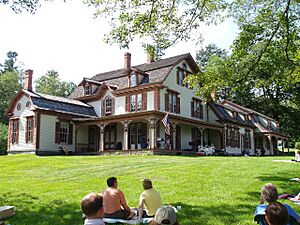
The well-known poet and newspaper editor William Cullen Bryant was born in Cummington. He loved the town so much that he returned to spend his summers there for many years. His old house is now a special place called the William Cullen Bryant Homestead. You can visit it and learn about his life.
Every August, Cummington hosts a fun event called the Cummington Fair. It takes place at the town's fairgrounds. The fair has many exciting things to see and do. You can find exhibits by adults and 4-H groups, a craft barn, and a vaudeville stage with live performances. There is also an antique car parade, oxen pulls, and lots of rides, games, and tasty food.
In 1945, a documentary film called The Cummington Story was made about the town. It showed how Cummington welcomed a group of refugees from Europe.
Understanding Cummington's Geography
Where is Cummington Located?
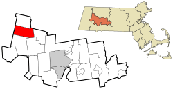
Cummington is in the northwestern part of Hampshire County. It shares its borders with several other towns. To the west, you will find Peru and Windsor in Berkshire County. To the north is Plainfield, and to the northeast is Ashfield in Franklin County. To the east is Goshen, to the southeast is Chesterfield, and to the south is Worthington. All these towns are in Hampshire County.
Land, Water, and Roads
The town covers a total area of about 59.7 square kilometers (about 23 square miles). Most of this area, 59.3 square kilometers, is land. A small part, about 0.3 square kilometers, is water. The Westfield River flows through Cummington.
Massachusetts Route 9 is a main road that runs through the town. It follows the Westfield River for much of its path. Route 9 goes southeast about 20 miles to Northampton. It also goes west about 22 miles to Pittsfield. Another road, Massachusetts Route 112, leads west and then south about 21 miles to Huntington.
What is Cummingtonite?
Did you know that a special mineral was first found in Cummington? It is called cummingtonite, and it was named after the town!
Who Lives in Cummington?
Population Facts
In 2000, there were 978 people living in Cummington. There were 382 households and 239 families. About 24.3% of households had children under 18. Most households (54.2%) were married couples living together.
The average age of people in Cummington in 2000 was 38 years old. About 27.9% of the population was under 18. About 11.2% of people were 65 years or older.
The median income for a household in the town was $42,250. This means half the households earned more and half earned less. About 6.6% of the population lived below the poverty line.
Learning in Cummington
Local School District
Cummington is part of the Central Berkshire Regional School District. This district also includes the towns of Becket, Dalton, Hinsdale, Peru, Washington, and Windsor.
Younger students attend Craneville School. Middle school students go to Nessacus Regional Middle School. High school students attend Wahconah Regional High School.
Places to Visit in Cummington
- William Cullen Bryant Homestead
- Greenwood Music Camp
Notable People from Cummington
- William Cullen Bryant, a famous poet
- Katherine Frazier, a musician and arts administrator
- Sergei Isupov, an artist
- Rachel Maddow, a well-known TV host
- Zalmon Richards, an educator
- William Jay Smith, a poet
- Worcester Reed Warner, an engineer
- Alan Weisman, an author
- Richard Wilbur, a poet
- Michael Bono, a guitarist
Images for kids
See also
 In Spanish: Cummington (Massachusetts) para niños
 | Aurelia Browder |
 | Nannie Helen Burroughs |
 | Michelle Alexander |


