Dalton, Massachusetts facts for kids
Quick facts for kids
Dalton, Massachusetts
|
||
|---|---|---|
| Town of Dalton | ||
 |
||
|
||
| Motto(s):
"Heaven in the heart of the Berkshires"
|
||
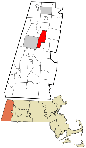
Location in Berkshire County and the state of Massachusetts.
|
||
| Country | ||
| State | ||
| County | Berkshire | |
| Settled | 1755 | |
| Incorporated | 1784 | |
| Named for | Tristram Dalton | |
| Government | ||
| • Type | Open town meeting | |
| Area | ||
| • Total | 56.7 km2 (21.9 sq mi) | |
| • Land | 56.4 km2 (21.8 sq mi) | |
| • Water | 0.3 km2 (0.1 sq mi) | |
| Elevation | 365 m (1,199 ft) | |
| Population
(2020)
|
||
| • Total | 6,330 | |
| • Density | 111.64/km2 (289.1/sq mi) | |
| • Demonym | Daltonian | |
| Time zone | UTC−5 (Eastern) | |
| • Summer (DST) | UTC−4 (Eastern) | |
| ZIP Code |
01226
|
|
| Area code(s) | 413 | |
| FIPS code | 25-16180 | |
| GNIS feature ID | 0619418 | |
Dalton is a town in Berkshire County, Massachusetts, United States. It's a place where city and country life meet in Berkshire County. Dalton is also part of the larger Pittsfield area. In 2020, about 6,330 people lived here.
Contents
History of Dalton
Dalton was first settled by people in 1755. It officially became a town in 1784. The town was named after Tristram Dalton. He was an important leader in the Massachusetts government at that time.
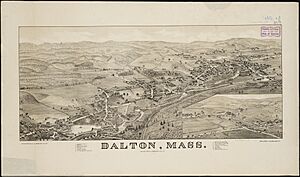
Dalton started as a mix of farming and small factories. Mills were built along the East Branch of the Housatonic River. In 1801, Zenas Crane and his partners started a paper mill there. By 1844, this mill began making special paper for money.
The company, Crane & Co., is still the biggest employer in Dalton. They make paper products and stationery. Since 1873, Crane & Co. has been the only company to make the paper for all United States paper money. For many years, trolleys connected Dalton to nearby Pittsfield.
In 1973, Dalton hosted a big event called the International Six Days Enduro. This event is like the "Olympics of Motorcycling." It's held in a different country each year and brings competitors from all over the world.
Geography of Dalton
Dalton is located in western Massachusetts. It covers about 56.7 square kilometers (21.9 square miles). Most of this area is land, with a small amount of water.
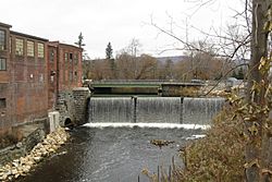
The town is bordered by several other towns. These include Cheshire, Windsor, Hinsdale, Washington, Pittsfield, and Lanesborough. Dalton's town center is about 5 miles (8 km) northeast of downtown Pittsfield.
The main part of Dalton is in the valley of the East Branch of the Housatonic River. Many small streams flow into this river. One stream has waterfalls called Wahconah Falls, which is a small state park.
Much of Dalton is covered by the the Berkshires mountains. The northern part of town is on a flat area between North Mountain and Western Mountain. This area is part of the Dalton Wildlife Management Area. The Appalachian Trail, a famous hiking path, also goes through Dalton.
Getting Around Dalton
Dalton is located where a few main roads meet. These include Massachusetts Route 8, Route 8A, and Route 9. Route 9 is an important road that goes across the state.
The nearest major highway is Interstate 90, also known as the Massachusetts Turnpike. Its closest exit is about 15 miles (24 km) south of Dalton. The Berkshire Regional Transit Authority offers bus service in the area.
A train line, owned by CSX Transportation, runs through Dalton. It carries freight and also Amtrak passenger trains. The closest train station for passengers is in Pittsfield. For air travel, the nearest small airport is in Pittsfield. For bigger flights, people use Albany International Airport in New York.
People of Dalton
| Historical population | ||
|---|---|---|
| Year | Pop. | ±% |
| 1850 | 1,020 | — |
| 1860 | 1,243 | +21.9% |
| 1870 | 1,252 | +0.7% |
| 1880 | 2,052 | +63.9% |
| 1890 | 2,885 | +40.6% |
| 1900 | 3,014 | +4.5% |
| 1910 | 3,568 | +18.4% |
| 1920 | 3,752 | +5.2% |
| 1930 | 4,220 | +12.5% |
| 1940 | 4,206 | −0.3% |
| 1950 | 4,772 | +13.5% |
| 1960 | 6,436 | +34.9% |
| 1970 | 7,505 | +16.6% |
| 1980 | 6,797 | −9.4% |
| 1990 | 7,155 | +5.3% |
| 2000 | 6,892 | −3.7% |
| 2010 | 6,756 | −2.0% |
| 2020 | 6,330 | −6.3% |
| 2022* | 6,236 | −1.5% |
| * = population estimate. Source: United States Census records and Population Estimates Program data. |
||
In 2000, there were 6,892 people living in Dalton. There were 2,712 households, which are groups of people living together. About 32.2% of these households had children under 18.
The population was spread out by age. About 25.8% of people were under 18. About 16.7% were 65 or older. The average age in Dalton was 40 years old. For every 100 females, there were about 91.5 males.
Dalton has churches for several Christian groups. These include a Congregational church, a Roman Catholic Church, a Methodist Church, an Episcopal church, and a Church of the Nazarene.
Education in Dalton
Dalton is part of the Central Berkshire Regional School District. Students in kindergarten through fifth grade go to Craneville Elementary School in Dalton. Nessacus Regional Middle School, also in Dalton, serves all middle school students in the district.
Wahconah Regional High School is the district's high school, and it's also located in Dalton. The school's sports teams are called the Warriors, and their colors are blue and white.
Dalton also has a private Catholic school called Saint Agnes Academy. It teaches students from pre-kindergarten through eighth grade. Other private schools are available in nearby Pittsfield.
The closest community college is Berkshire Community College in Pittsfield. For a four-year college, the nearest state school is Massachusetts College of Liberal Arts in North Adams. The closest university is the University of Massachusetts Amherst.
Dalton also gave its name to an education idea called the Dalton Plan. This plan was developed by Helen Parkhurst.
Notable People from Dalton
- Dan Duquette, a former manager for baseball teams like the Boston Red Sox
- Mary Cutler Fairchild (1855–1921), a librarian and teacher
- Jeff Reardon, a baseball player who played for 16 years in Major League Baseball
- Anton Strout, a popular author of fantasy and science fiction books
- David H. Tower, an architect who designed many paper mills, including some for Crane & Co.
- Turk Wendell, a former Major League Baseball pitcher
See also
 In Spanish: Dalton (Massachusetts) para niños
 | Claudette Colvin |
 | Myrlie Evers-Williams |
 | Alberta Odell Jones |


