Deerfield (CDP), Massachusetts facts for kids
Quick facts for kids
Deerfield, Massachusetts
|
|
|---|---|

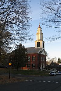
The First Church of Deerfield
|
|

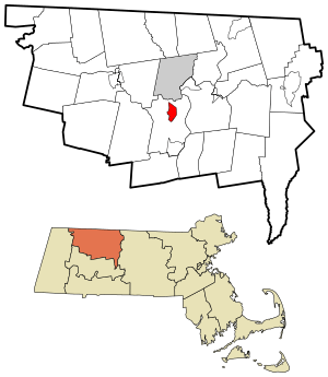
Location in Franklin County in Massachusetts
|
|
| Country | United States |
| State | Massachusetts |
| County | Franklin |
| Town | Deerfield |
| Area | |
| • Total | 1.87 sq mi (4.84 km2) |
| • Land | 1.84 sq mi (4.76 km2) |
| • Water | 0.03 sq mi (0.08 km2) |
| Elevation | 164 ft (50 m) |
| Population
(2020)
|
|
| • Total | 479 |
| • Density | 260.75/sq mi (100.69/km2) |
| Time zone | UTC-5 (Eastern (EST)) |
| • Summer (DST) | UTC-4 (EDT) |
| ZIP codes |
01342
|
| Area code(s) | 413 |
| FIPS code | 25-16635 |
| GNIS feature ID | 0608850 |
Deerfield is a special kind of community in Franklin County, Massachusetts. It is called a census-designated place (CDP). This means it is an area that the government counts for population, but it is not a separate town or city. Deerfield is part of the larger town of Deerfield.
In 2020, about 479 people lived in this part of Deerfield. The area is famous for its history. It is also home to Deerfield Academy, a well-known school that prepares students for college.
Contents
Where is Deerfield Located?
Deerfield is found in the state of Massachusetts, in the United States. It is part of Franklin County. The area is known for its beautiful natural surroundings.
Deerfield's Size and Land
The total area of Deerfield is about 1.87 square miles (4.84 square kilometers). Most of this area is land. Only a small part, about 0.03 square miles (0.08 square kilometers), is water. This water usually comes from small streams or ponds.
Who Lives in Deerfield?
Counting people helps us understand communities. The United States government counts people every ten years. This is called a census.
Deerfield's Population
In 2020, the census showed that 479 people lived in Deerfield. This number helps us see how the community changes over time.
Historic Deerfield Village
One of the most important parts of Deerfield is Historic Deerfield. This area is like an outdoor museum. It shows what life was like in early American times.
Exploring History at Historic Deerfield
Historic Deerfield has many old buildings. These include homes, shops, and a church. Visitors can walk through these buildings. They can learn about the people who lived there long ago. It is a great place to learn about history.
Deerfield Academy
Deerfield is also home to Deerfield Academy. This is a private school. Students from all over the world come here. They prepare for college. The school has a long history. It is an important part of the community.
Images for kids
See also
 In Spanish: Deerfield (condado de Franklin) para niños
 | Jackie Robinson |
 | Jack Johnson |
 | Althea Gibson |
 | Arthur Ashe |
 | Muhammad Ali |


