Satan's Kingdom, Massachusetts facts for kids
Quick facts for kids
Satan's Kingdom, Massachusetts
|
|
|---|---|
|
Village
|
|

Satan's Kingdom Wildlife Management Area
|
|
| Country | United States |
| State | Massachusetts |
| County | Franklin |
| Town | Northfield |
| Satan's Kingdom | 1958 |
| Elevation | 374 ft (114 m) |
| Time zone | UTC-5 (Eastern (EST)) |
| • Summer (DST) | UTC-4 (EDT) |
| Area code(s) | 413 |
| GNIS feature ID | 609340 |
Satan's Kingdom is a small, quiet village located in the town of Northfield, Massachusetts. It's in Franklin County, close to the border with Vermont. This unique place is known for its interesting name and beautiful natural areas.
Contents
Why is it Called Satan's Kingdom?
Satan's Kingdom has a very unusual name! There are a couple of stories about how it got this name.
The Forest Fire Story
One story says the name came from a forest fire. A person from Northfield was leaving church after hearing a sermon. This sermon talked about the "fires of hell." When they looked across the Connecticut River, they saw a big forest fire. They then said, "Satan's Kingdom is burning!" This is how the name might have started.
The Wildlife Story
Another idea is that the name came from the village's reputation for having dangerous animals. People thought there were many venomous snakes there. So, the area was called "Satan's Kingdom" because of its wild nature.
It's important to know that Satan's Kingdom is not an official town or city. It's a small community within Northfield.
A Look at History
Satan's Kingdom has a long history. It was the location of several attacks during a conflict called King Philip's War. This war happened in the 1670s. It was a major conflict between Native Americans and English colonists in New England.
Nature and Geography
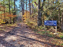
A large part of Satan's Kingdom is covered by the Satan's Kingdom Wildlife Management Area. This is a special natural area. The Massachusetts Division of Fisheries and Wildlife manages it.
Exploring the Wildlife Area
This wildlife area is huge, covering about 1,800 acres. That's like 1,360 football fields! It's a very popular spot for people who love to hike. You can explore the trails and enjoy nature. It's a great place to see local plants and animals.
 | Charles R. Drew |
 | Benjamin Banneker |
 | Jane C. Wright |
 | Roger Arliner Young |


