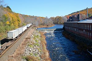
West Warren, Massachusetts facts for kids
Quick facts for kids
West Warren, Massachusetts
|
|
|---|---|

Wrights Complex Lower Dam
|
|
| Country | |
| State | Massachusetts |
| County | Worcester |
| Town | Warren |
| Area | |
| • Total | 1.27 sq mi (3.30 km2) |
| • Land | 1.27 sq mi (3.28 km2) |
| • Water | 0.01 sq mi (0.02 km2) |
| Elevation | 545 ft (166 m) |
| Population
(2020)
|
|
| • Total | 721 |
| • Density | 569.06/sq mi (219.65/km2) |
| Time zone | UTC-5 (Eastern (EST)) |
| • Summer (DST) | UTC-4 (EDT) |
| ZIP Code |
01092
|
| Area code(s) | 413 |
| FIPS code | 25-78445 |
| GNIS feature ID | 2806313 |
West Warren is a small village located in the town of Warren, in Worcester County, Massachusetts, United States. It is known as a census-designated place (CDP). A CDP is a special area that the United States Census Bureau defines for gathering population data. It is like a neighborhood or community that isn't officially a city or town.
West Warren is found on the north side of the Quaboag River. It is along Massachusetts Route 67. The village is about 2.5 miles west of the main Warren village. It is also about 9 miles northeast of Palmer.
What is a Census-Designated Place?
A census-designated place (CDP) is an area that the U.S. Census Bureau identifies. It helps them collect information about how many people live there. These places are not officially separate cities or towns. They do not have their own local government. Instead, they are part of a larger town or county. West Warren was first listed as a CDP before the 2020 census. This means it was recognized for counting its population.
How Many People Live Here?
The number of people living in a place is called its population. This information is collected during a census. A census is a count of all people in a country.
Population in West Warren
According to the 2020 census, 721 people lived in West Warren. This number helps us understand the size of the community.
| Historical population | |||
|---|---|---|---|
| Census | Pop. | %± | |
| 2020 | 721 | — | |
| U.S. Decennial Census | |||
 | Aaron Henry |
 | T. R. M. Howard |
 | Jesse Jackson |


