Hopedale (CDP), Massachusetts facts for kids
Quick facts for kids
Hopedale, Massachusetts
|
|
|---|---|

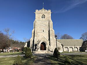
Hopedale Unitarian Parish
|
|
| Country | |
| State | Massachusetts |
| County | Worcester |
| Town | Hopedale |
| Area | |
| • Total | 1.75 sq mi (4.54 km2) |
| • Land | 1.75 sq mi (4.53 km2) |
| • Water | 0.00 sq mi (0.01 km2) |
| Elevation | 284.4 ft (86.7 m) |
| Population
(2020)
|
|
| • Total | 3,939 |
| • Density | 2,253.43/sq mi (869.85/km2) |
| Time zone | UTC-5 (Eastern (EST)) |
| • Summer (DST) | UTC-4 (EDT) |
| ZIP Code |
01747
|
| Area code(s) | 508/774 |
| FIPS code | 25-30980 |
| GNIS feature ID | 2378143 |
Hopedale is a special kind of community called a census-designated place (CDP). This means it's an area that the U.S. Census Bureau has defined for gathering information. It's the main village within the larger town of Hopedale. You can find it in Worcester County, Massachusetts, in the United States.
In 2010, about 3,753 people lived in this part of Hopedale. The whole town of Hopedale had a population of 5,911 people at that time.
Where is Hopedale Located?
Hopedale is surrounded by other towns. To its northeast, you'll find the town of Milford. To the southwest, it borders the town of Mendon.
It's also not too far from some bigger cities. Hopedale is about 33 miles (53 km) southwest of Boston, which is the capital city of Massachusetts. It's also about 18 miles (29 km) southeast of Worcester. If you head north for about 25 miles (40 km), you'll reach Providence, Rhode Island.
Massachusetts Route 16 is a main road that goes through Hopedale. This road can take you northeast about 1.5 miles (2.4 km) to the center of Milford. If you go southwest on Route 16, it's about 6 miles (9.7 km) to Uxbridge.
Population Information
The number of people living in Hopedale changes over time. The U.S. Census counts everyone every ten years.
- 2020: 3,939 people
See Also
- Hopedale (condado de Worcester) para niños (This link is to the Kiddle encyclopedia in Spanish)
 | Roy Wilkins |
 | John Lewis |
 | Linda Carol Brown |


