
Oxford, Maine facts for kids
Quick facts for kids
Oxford, Maine
|
|
|---|---|

Congregational Church, c. 1909
|
|

Oxford, Maine
Location in Maine

Oxford, Maine
Location in the United States
|
|
| Country | United States |
| State | Maine |
| County | Oxford |
| Incorporated | 1829 |
| Area | |
| • Total | 41.88 sq mi (108.47 km2) |
| • Land | 38.72 sq mi (100.28 km2) |
| • Water | 3.16 sq mi (8.18 km2) |
| Population
(2020)
|
|
| • Total | 4,229 |
| • Density | 109.2/sq mi (42.17/km2) |
| Time zone | UTC-5 (Eastern (EST)) |
| • Summer (DST) | UTC-4 (EDT) |
| ZIP code |
04270
|
Oxford is a town located in Oxford County, Maine, in the United States. It is part of the larger Lewiston-Auburn, Maine metropolitan area. In 2020, about 4,229 people lived here. Oxford is known for places like the Oxford Plains Speedway, Kamp Kohut, the yearly Oxford County Fair, and Oxford Casino. The town also includes a small village called Welchville.
Contents
History of Oxford, Maine
The land where Oxford is now was once called Bog Brook Plantation. It was given to Alexander Shepard Jr. in 1777. Later, in 1792, this area became part of a town called Hebron.
Founding and Growth
Oxford was first settled in 1794. It officially became its own town on February 27, 1829. Over time, Oxford added land from nearby towns like Otisfield in 1830 and Paris in 1838. The town was named after the famous city of Oxford, in England.
Farmers in Oxford mainly grew hay, and the town became well-known for its cattle.
Mills and Railroads
In the 1800s, mills were built near two water power sites. These areas grew into important villages, especially after the Grand Trunk Railway arrived in the 1850s.
Welchville village was located on the Little Androscoggin River. Here, the Harper Manufacturing Company built a woolen textile mill.
Another village, Oxford village, was at the end of Thompson Lake. It was first called Craigie's Mill. This was because Andrew Craigie, a businessman from Boston, built a sawmill and a gristmill there. Other factories in Oxford village made barrel staves and shovel handles. The Robinson Manufacturing Company also had woolen textile mills there.
Tourism and Modern Times
The railroad also brought many visitors to Thompson Lake. Inns and hotels opened to welcome these seasonal tourists. Today, Oxford is a popular place for recreation. You can still see beautiful old buildings from its past as a busy mill town. The Congregational Church, built between 1842 and 1843, is a historic building. It is listed on the National Register of Historic Places.
On June 5, 2010, an F1 tornado hit the town. It caused some serious damage.
Geography and Location
Oxford, Maine, covers a total area of about 41.88 square miles (108.47 square kilometers). Most of this area, about 38.72 square miles (100.28 square kilometers), is land. The rest, about 3.16 square miles (8.18 square kilometers), is water.
Rivers and Lakes
The town is drained by the Little Androscoggin River. This means the river flows through and carries water away from the area. Thompson Lake is the biggest lake in Oxford. It is about 8 miles (13 kilometers) long.
Neighboring Towns
Oxford is served by state routes 26 and 121. It shares borders with several other towns:
- Paris to the north
- Hebron to the northeast
- Norway to the northwest
- Poland to the southeast
- Otisfield to the southwest
Population Changes Over Time
The population of Oxford has changed quite a bit over the years. Here's a look at how many people have lived in the town since 1800:
| Historical population | |||
|---|---|---|---|
| Census | Pop. | %± | |
| 1800 | 69 | — | |
| 1830 | 1,116 | — | |
| 1840 | 1,254 | 12.4% | |
| 1850 | 1,233 | −1.7% | |
| 1860 | 1,281 | 3.9% | |
| 1870 | 1,631 | 27.3% | |
| 1880 | 1,655 | 1.5% | |
| 1890 | 1,455 | −12.1% | |
| 1900 | 1,331 | −8.5% | |
| 1910 | 1,221 | −8.3% | |
| 1920 | 1,097 | −10.2% | |
| 1930 | 1,125 | 2.6% | |
| 1940 | 1,316 | 17.0% | |
| 1950 | 1,569 | 19.2% | |
| 1960 | 1,658 | 5.7% | |
| 1970 | 1,892 | 14.1% | |
| 1980 | 3,143 | 66.1% | |
| 1990 | 3,705 | 17.9% | |
| 2000 | 3,960 | 6.9% | |
| 2010 | 4,110 | 3.8% | |
| 2020 | 4,229 | 2.9% | |
| U.S. Decennial Census | |||
People from Oxford
You can find more information about people who come from Oxford, Maine, by looking at the.
Images for kids
-
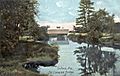
Covered bridge c. 1907
-
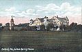
Oxford Spring House in 1907
-
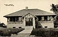
Freeland Holmes Library in 1916


See also
 In Spanish: Oxford (Maine) para niños
