
Hebron, Maine facts for kids
Quick facts for kids
Hebron, Maine
|
|
|---|---|

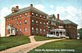
Sturtevant Hall, Hebron Academy
|
|

Hebron, Maine
Location in Maine

Hebron, Maine
Location in the United States
|
|
| Country | United States |
| State | Maine |
| County | Oxford |
| Incorporated | 1792 |
| Area | |
| • Total | 22.54 sq mi (58.38 km2) |
| • Land | 22.41 sq mi (58.04 km2) |
| • Water | 0.13 sq mi (0.34 km2) |
| Elevation | 531 ft (162 m) |
| Population
(2020)
|
|
| • Total | 1,223 |
| • Density | 55/sq mi (21.1/km2) |
| Time zone | UTC-5 (Eastern (EST)) |
| • Summer (DST) | UTC-4 (EDT) |
| ZIP code |
04238
|
| Area code(s) | 207 |
| FIPS code | 23-32370 |
| GNIS feature ID | 0582516 |
Hebron is a small town in Oxford County, Maine, United States. It is part of the larger Lewiston-Auburn, Maine metropolitan area. Hebron is well-known for Hebron Academy, a school that helps students get ready for college. This school is a big part of the town's history. In 2020, about 1,223 people lived in Hebron. The town also has an elementary school called Hebron Station School.
Contents
Hebron's Early Days
Hebron was first given out on March 8, 1777. The Massachusetts General Court gave the land to Alexander Shepard, Jr. He received it as payment for helping to create a map of the Maine coast. The area was first called Shepardsfield Plantation. However, early settlers often called it Bog Brook Plantation.
A farm was settled in 1764 on what is now Sodom Road in Hebron. This was even before the American Revolution. The first official settlers of Shepardsfield Plantation were Captain Daniel Buckman and his family in 1778. Many others followed, including soldiers who had just fought in the American Revolutionary War. On February 27, 1829, the southwestern part of Hebron became its own town, called Oxford.
Life and Growth in Hebron
In the early days, agriculture was the main job in Hebron. Farmers mostly grew hay. The town was also known for its good orchards. Marshall Pond, the largest body of water, provided power for mills. These mills helped the town grow.
Hebron had a sawmill and a shingle mill. There was also a factory that made pails. Local shops included a blacksmith shop and a shoe shop. In 1804, Deacon William Barrows, Jr. helped start Hebron Academy. This school became a very important part of the town. Later, the Rumford Falls and Buckfield Railroad passed through Hebron, connecting it to other places.
In 1904, the Western Maine Sanatorium opened in Hebron. This was the first hospital of its kind in Maine. It helped people with tuberculosis by giving them rest, fresh air, and healthy food. The state took over the sanatorium in 1915, but it closed in 1959.
Hebron's Geography
Hebron covers about 22.54 square miles (58.38 square kilometers) in total. Most of this area, about 22.41 square miles (58.04 square kilometers), is land. A small part, about 0.13 square miles (0.34 square kilometers), is water. Several small streams flow through Hebron, including Cobb Brook, Cushman Brook, Bicknell Brook, and Allen Brook.
Maine State Route 119 crosses through the town. Hebron shares its borders with several other towns. To the north is Buckfield. To the south is Oxford. Paris is to the west, and Turner and Minot are to the east.
Hebron is also famous for a special gem called Rubellite Tourmaline. This beautiful stone was found on Mt. Rubellite, located in Hebron Center.
Population Information
| Historical population | |||
|---|---|---|---|
| Census | Pop. | %± | |
| 1800 | 981 | — | |
| 1810 | 1,211 | 23.4% | |
| 1820 | 1,727 | 42.6% | |
| 1830 | 915 | −47.0% | |
| 1840 | 945 | 3.3% | |
| 1850 | 839 | −11.2% | |
| 1860 | 895 | 6.7% | |
| 1870 | 744 | −16.9% | |
| 1880 | 601 | −19.2% | |
| 1890 | 600 | −0.2% | |
| 1900 | 494 | −17.7% | |
| 1910 | 603 | 22.1% | |
| 1920 | 652 | 8.1% | |
| 1930 | 791 | 21.3% | |
| 1940 | 678 | −14.3% | |
| 1950 | 829 | 22.3% | |
| 1960 | 465 | −43.9% | |
| 1970 | 532 | 14.4% | |
| 1980 | 665 | 25.0% | |
| 1990 | 878 | 32.0% | |
| 2000 | 1,053 | 19.9% | |
| 2010 | 1,416 | 34.5% | |
| 2020 | 1,223 | −13.6% | |
| U.S. Decennial Census | |||
Hebron's Population in 2010
In 2010, the town of Hebron had 1,416 people living there. There were 449 households, and 343 of these were families. The population density was about 63 people per square mile. There were 483 homes in total.
Most of the people in Hebron were White (93.9%). A smaller number were African American (1.1%), Native American (0.3%), or Asian (3.5%). About 1.3% of the people were from two or more races. Hispanic or Latino people made up 1.6% of the population.
About 38% of households had children under 18 living with them. Most households (59.5%) were married couples living together. About 15.6% of all households were made up of people living alone. The average household had about 2.76 people.
The average age in Hebron was 33.4 years old. About 29.8% of residents were under 18. About 10.8% were between 18 and 24 years old. People aged 25 to 44 made up 24.2% of the population. Those aged 45 to 64 were 28.4%, and 7.1% were 65 or older. Slightly more than half of the population (52.6%) was male, and 47.4% was female.
Notable People
- Horace A. Barrows – A doctor from the 1800s.
- Albion K. Parris – A US senator and the fifth governor of Maine.
Images for kids
-
Sturtevant Home in 1907

See also
 In Spanish: Hebron (Maine) para niños
